
Pushpagiri WLS topographic map
Click on the map to display elevation.
About this map
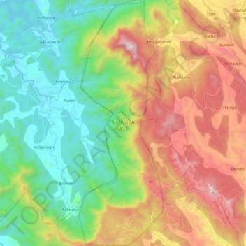
Name: Pushpagiri WLS topographic map, elevation, terrain.
Location: Pushpagiri WLS, Kodagu, Karnataka, India (12.49038 75.63846 12.70323 75.71385)
Average elevation: 720 m
Minimum elevation: 104 m
Maximum elevation: 1,706 m
Other topographic maps
Click on a map to view its topography, its elevation and its terrain.
Bengaluru
India > Karnataka > Bangalore North
Bengaluru (formerly Bangalore) is situated in the southeastern part of Karnataka, India, within the Bengaluru Urban district. It lies at an elevation of approximately 900 meters (3,000 feet) above sea level, on the Deccan Plateau. This elevated position gives the city a moderate climate, with temperatures…
Average elevation: 881 m
Bengaluru
India > Karnataka > Bangalore North
Bengaluru lies in the southeast of the South Indian state of Karnataka in the heart of the Mysore Plateau (a region of the larger Deccan Plateau) at an average elevation of 900 m (2,953 ft). The city covers an area of 741 km2 (286 sq mi). The Bengaluru metropolitan region covers an area of 7,005 km2 (2,705 sq…
Average elevation: 879 m
Mangaluru
India > Karnataka > Mangaluru taluk
Mangalore is also the administrative headquarters of the Dakshina Kannada district; it is a commercial, industrial, educational, healthcare, and startup hub. The city's international airport is the second-largest and second-busiest airport in Karnataka. Mangalore City Corporation is responsible for the civic…
Average elevation: 25 m
Srinivaspur
India > Karnataka > Srinivasapura taluku
Srinivaspur is located at 13°20′N 78°13′E / 13.33°N 78.22°E / 13.33; 78.22. It has an average elevation of 819 metres (2,687 ft). The geographical area of the taluk is 860 square kilometres (330 sq mi).
Average elevation: 830 m
Bidar
Physiographically, the district can be divided into two regions, the northern low lands and southern high lands. The southern high lands are popularly known as Bidar plateau, which is made up of laterite. The ground altitudes are varying from 420 to 684 m (1,378 to 2,244 ft) above sea level. Bidar plateau has…
Average elevation: 576 m
Uttara Kannada
The district's high rainfall supports lush forests, which cover approximately 70% of the district. The Malabar Coast moist forests ecoregion lies in a narrow strip between the Arabian Sea and the foothills of the Western Ghats up to 250 meters elevation. These forests have been almost completely converted to…
Average elevation: 364 m
Malaprabha
The Malaprabha River (Kannada ಮಲಪ್ರಭಾ ನದಿ) is a tributary of the Krishna River and flows through the state of Karnataka in India.[citation needed] It rises in the Western Ghats at an elevation of 792.4 m (2,600 ft) in the state's Belgaum district. The river joins Krishna River at…
Average elevation: 608 m
Kalaburagi
Kalaburagi is situated in Deccan Plateau located at 17°20′N 76°50′E / 17.33°N 76.83°E / 17.33; 76.83 and the general elevation ranges from 300 to 750 meters above mean sea level. The main river is the Bhima.
Average elevation: 497 m
Ramanagara
Ramanagara is approximately 50 km southwest of Bangalore. The district shares borders with the districts of Bangalore Urban in the east, Bangalore Rural in the North-east, Tumakuru in the North-west, Mandya in the west and Chamarajanagara in the south-west and Krishnagiri district of Tamilnadu state in the…
Average elevation: 764 m
Ghataprabha
The source of the river can be identified from Phatakwadi Lake 15°56′22″N 74°03′34″E / 15.939335°N 74.059535°E / 15.939335; 74.059535, at an elevation of 750 metres above mean sea level.
Average elevation: 605 m
Coorg
Kodagu is located on the eastern slopes of the Western Ghats. It has a geographical area of 4,102 km2 (1,584 sq mi). The district is bordered by Dakshina Kannada district to the northwest, Hassan district to the north, Mysore district to the east, Kasaragod district of Kerala in west and Kannur district of…
Average elevation: 560 m
Kalaburagi
India > Karnataka > Kalaburagi taluku
The entire district is on the Deccan Plateau, and the elevation ranges from 300 to 750 m above MSL. Two main rivers, the Krishna and Bhima, flow through the district. The predominant soil type is black soil. The district has many tanks, which irrigate the land along with the river. The Upper Krishna Project is…
Average elevation: 465 m
Hunsur
India > Karnataka > Hunasuru taluk
Hunsur is located at 12°19′N 76°17′E / 12.31°N 76.29°E / 12.31; 76.29. It is located at an elevation of 805 metres (2,641 ft) above mean sea level. The river Lakshmana Tirtha flows through the town and two bridges are built across the river. The town is the administrative center of Hunsur…
Average elevation: 792 m
Belagavi
India > Karnataka > Belagavi taluku
Belgaum is located at 15°52′N 74°30′E / 15.87°N 74.5°E / 15.87; 74.5. It has an average elevation of 751 metres (2,464 feet). The city is in the northwestern parts of Karnataka and lies at the border of two states, Maharashtra and Goa on the western ghats (50 km (31 mi) from the Goa state…
Average elevation: 760 m
Haveri
India > Karnataka > Haveri taluku
Haveri is located at 14°48′N 75°24′E / 14.8°N 75.4°E / 14.8; 75.4. It has an average elevation of 572 metres (1876 feet).
Average elevation: 564 m
Madikeri
India > Karnataka > Madikeri taluku
Madikeri features a tropical highland climate as it has an elevation of 1,170 m (3,840 ft). Madikeri is located at 12°25′N 75°44′E / 12.42°N 75.73°E / 12.42; 75.73. Madikeri lies in the Western Ghats and is a popular hill station. The nearest cities are Hassan to the north, Mangaluru to the…
Average elevation: 1,054 m
Kolar
India > Karnataka > Kolar taluk
Kolar is located at 13°08′N 78°08′E / 13.13°N 78.13°E / 13.13; 78.13. with an average elevation of 849 metres (2,785 ft).
Average elevation: 847 m
Mandya
India > Karnataka > Mandya taluk
Mandya is located at 12°31′N 76°54′E / 12.52°N 76.9°E / 12.52; 76.9. It has an average elevation of 678 metres (2,224 ft).
Average elevation: 693 m
Nelamangala
India > Karnataka > Nelamangala taluk
{{Infobox settlement | name = Nelamangala | native_name = ನೆಲಮಂಗಲ | native_name_lang = kn | other_name = | nickname = | settlement_type = City | image_skyline = | image_alt = | image_caption = | pushpin_map = India Karnataka#India#Asia | pushpin_label_position = right | pushpin_map_alt = |…
Average elevation: 884 m
Ranebennur
India > Karnataka > Ranebennuru taluk
Ranebennuru is at the geographical center of Karnataka. 14°37′N 75°37′E / 14.62°N 75.62°E / 14.62; 75.62. It has an average elevation of 605 metres (1,985 ft). One of Karnataka's most important rivers – the Tungabhadra – flows along the southern border of Ranebennur taluk. Another river,…
Average elevation: 574 m