
Ramanagara topographic map
Click on the map to display elevation.
Ramanagara
Ramanagara is approximately 50 km southwest of Bengaluru. The district shares borders with the districts of Bangalore Urban in the east, Bangalore Rural in the North-east, Tumkur in the North-west, Mandya in the west and Chamarajanagar in the south-west and Krishnagiri district of Tamilnadu state in the south. It has an average elevation of 747 metres (2450 feet). Ramanagara is famous for the huge rocky outcroppings. The popular places for rock climbing are; Savandurga which is 31km away from Ramanagara, Ramadevarabetta located within the city, Sri Revana Siddeshwara (SRS) betta which is 15.1km away from Ramanagara, Thenginkalbetta near to SRS betta and Kabbaladurga which is 35km away from Ramanagara.
About this map
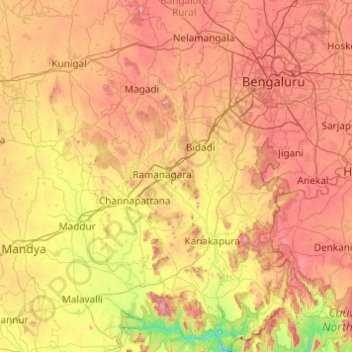
Name: Ramanagara topographic map, elevation, terrain.
Location: Ramanagara, Karnataka, India (12.24325 77.06806 13.19697 77.63503)
Average elevation: 764 m
Minimum elevation: 368 m
Maximum elevation: 1,291 m
Other topographic maps
Click on a map to view its topography, its elevation and its terrain.
Udupi
India > Karnataka > Udupi taluku
Udupi has an elevation of 27 m (89 ft) above mean sea level. The climate in Udupi is hot in summers and pleasant in winter. During summers (from March to May) the temperature reaches up to 38 °C (100 °F) and in winters (from December to February) it is usually between 32 and 20 °C (90 and 68 °F). As it is…
Average elevation: 17 m
Siruguppa
India > Karnataka > Siruguppa taluku
Siruguppa is located at 15°38′N 76°54′E / 15.63°N 76.9°E / 15.63; 76.9. Located on the Deccan plateau, it has an average elevation of 373 metres (1223 feet). It belongs to the dry inland region of Karnataka with an annual rainfall of 645 mm. The Taluk is bounded in the south by Bellary taluk,…
Average elevation: 372 m
Kolar
India > Karnataka > Kolar taluk
Kolar is located at 13°08′N 78°08′E / 13.13°N 78.13°E / 13.13; 78.13.[3] with an average elevation of 849 metres (2,785 ft).
Average elevation: 847 m
Challakere
India > Karnataka > Challakere taluku
Challakere is located at 14°18′43″N 76°39′04″E / 14.312°N 76.651°E / 14.312; 76.651. It has an average elevation of 585 metres (1919 ft).
Average elevation: 583 m
Gauribidanuru
India > Karnataka > Gauribidanuru taluk
Gauribidanur is at 13°37′N 77°31′E / 13.61°N 77.52°E / 13.61; 77.52. It has an average elevation of 694 metres (2276 feet).
Average elevation: 691 m
Srirangapatna
India > Karnataka > Srirangapattana taluk
Srirangapatna is at 12°25′N 76°42′E / 12.41°N 76.7°E / 12.41; 76.7. It has an average elevation of 679 metres (2227 feet). Srirangapatna Sangama is the confluence of the three holy streams creating the island. Located 27 km upstream from the town is the spectacular Shivanasamudra Falls, the…
Average elevation: 693 m
Chikkanayakanahalli
India > Karnataka > Chikkanayakanahalli taluk > Chikkanayakanahalli
Chikkanayakana-halli is located at 13°25′N 76°37′E / 13.42°N 76.62°E / 13.42; 76.62. It has an average elevation of 804 metres (2,637 feet).
Average elevation: 811 m
Shikaripura
India > Karnataka > Shikaripura taluk
Shikaripur is located at 14°16′N 75°21′E / 14.27°N 75.35°E / 14.27; 75.35. It has an average elevation of 603 m (1978 ft). It lies on tropical forests of Malenadu region. Shikaripura is one of the junction to connect north karnataka to Malenadu. And the river kumadvati flows from the town and…
Average elevation: 610 m
Hiriyur
India > Karnataka > Hiriyuru taluk
Hiriyur is located at 13°57′N 76°37′E / 13.95°N 76.62°E / 13.95; 76.62. It has an average elevation of 630 metres (2066 feet). The months of March and April are the hottest months of the year.
Average elevation: 613 m
Madhugiri
India > Karnataka > Madhugiri taluk
Madhugiri is located at 13°40′N 77°13′E / 13.66°N 77.21°E / 13.66; 77.21. It has an average elevation of 787 metres (2582 feet).
Average elevation: 783 m
Alnavar
India > Karnataka > Alnavara taluku
Alnavar is located at 15°26′N 74°44′E / 15.43°N 74.73°E / 15.43; 74.73. It has an average elevation of 563 metres (1847 feet). Trains from Bangalore to Vasco da Gama passes through this town.
Average elevation: 575 m
Turuvekere
India > Karnataka > Turuvekere taluk
Turuvekere is located at 13°10′N 76°40′E / 13.16°N 76.67°E / 13.16; 76.67, about 12 km, South of the Banasandra railway station. It has an average elevation of 794 metres (2604 feet).
Average elevation: 802 m
Kaduru
India > Karnataka > Kaduru taluk
Kadur is located in the eastern part of Chikmagalur district, which has a semi-arid climate. Its elevation is around 760 metres above the mean sea level. It has a dry climate with annual rainfall less than 750 millimetres (30 in).
Average elevation: 765 m
Channagiri
India > Karnataka > Channagiri taluku
Channagiri is located at 14°02′N 75°56′E / 14.03°N 75.93°E / 14.03; 75.93. It has an average elevation of 662 metres (2171 feet).
Average elevation: 679 m
Krishnarajanagara
India > Karnataka > Krishnarajanagara taluk
Krishnarajanagara is located on the northern part of Mysore district, west of the Krishna Raja Sagara Reservoir. It has an average elevation of 786 metres above sea level. NH-373, also known as SH-57 passes through the town of K.R.Nagara.
Average elevation: 786 m
Moodabidri
India > Karnataka > Moodabidri taluk
Its average elevation is 147 metres (482 ft).
Average elevation: 111 m
Bidar
India > Karnataka > Bidar taluku
Bidar is located at 17°54′N 77°30′E / 17.9°N 77.5°E / 17.9; 77.5, lies at a central position in Deccan, a plateau at an elevation of 2300 ft from the sea level. It has common boundaries with Maharashtra and Telangana which is, with the districts of Nizamabad and Medak in Telangana on the East…
Average elevation: 593 m