
Make a donation
Gear up for your next adventure:
As an Amazon Associate, this site earns from qualifying purchases at no extra cost to you.
Atherstone topographic map
Click on the map to display elevation.
Make a donation
Gear up for your next adventure:
As an Amazon Associate, this site earns from qualifying purchases at no extra cost to you.
About this map
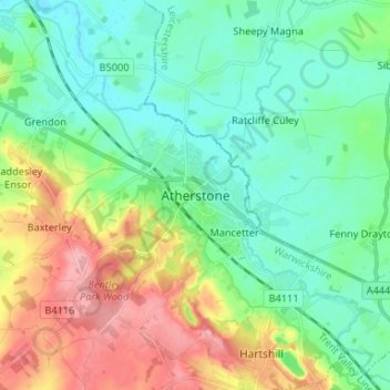
Name: Atherstone topographic map, elevation, terrain.
Average elevation: 101 m
Minimum elevation: 63 m
Maximum elevation: 182 m
Warwickshire trails, hiking, mountain biking, running and outdoor activities
Make a donation
Gear up for your next adventure:
As an Amazon Associate, this site earns from qualifying purchases at no extra cost to you.
Other topographic maps
Click on a map to view its topography, its elevation and its terrain.
Make a donation
Gear up for your next adventure:
As an Amazon Associate, this site earns from qualifying purchases at no extra cost to you.
Pooley Country Park
United Kingdom > England > Warwickshire > North Warwickshire > Polesworth
Average elevation: 76 m
Hartshill Hayes Country Park
United Kingdom > England > Warwickshire > North Warwickshire > Ansley Common
Average elevation: 127 m
Make a donation
Gear up for your next adventure:
As an Amazon Associate, this site earns from qualifying purchases at no extra cost to you.
Merevale Lake
United Kingdom > England > Warwickshire > North Warwickshire > Atherstone
Average elevation: 119 m
Make a donation
Gear up for your next adventure:
As an Amazon Associate, this site earns from qualifying purchases at no extra cost to you.
Make a donation
Gear up for your next adventure:
As an Amazon Associate, this site earns from qualifying purchases at no extra cost to you.
Holbech's Wood
United Kingdom > England > Warwickshire > North Warwickshire > Fillongley CP
Average elevation: 140 m
Hoar Park
United Kingdom > England > Warwickshire > North Warwickshire > Bentley CP
Average elevation: 135 m
Make a donation
Gear up for your next adventure:
As an Amazon Associate, this site earns from qualifying purchases at no extra cost to you.
Lea Marston Purification Lakes
United Kingdom > England > Warwickshire > North Warwickshire > Marston
Average elevation: 70 m
Make a donation
Gear up for your next adventure:
As an Amazon Associate, this site earns from qualifying purchases at no extra cost to you.
Make a donation
Gear up for your next adventure:
As an Amazon Associate, this site earns from qualifying purchases at no extra cost to you.