
Make a donation
Gear up for your next adventure:
As an Amazon Associate, this site earns from qualifying purchases at no extra cost to you.
Jiwaka topographic map
Click on the map to display elevation.
Make a donation
Gear up for your next adventure:
As an Amazon Associate, this site earns from qualifying purchases at no extra cost to you.
Jiwaka
"Jiwaka" is a portmanteau word combining the first two letters each from the word Jimi, Waghi and Kambia. Jimi, Waghi and Kambia denote the topographical landscape referencing the Valley (Waghi Valley) and the mountain ranges at the north (Jimi) and south (Kambia).
Make a donation
Gear up for your next adventure:
As an Amazon Associate, this site earns from qualifying purchases at no extra cost to you.
About this map
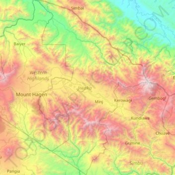
Name: Jiwaka topographic map, elevation, terrain.
Location: Jiwaka, Highlands Region, Papua New Guinea (-6.40364 144.27392 -5.23220 145.02958)
Average elevation: 1,573 m
Minimum elevation: 53 m
Maximum elevation: 4,451 m
Make a donation
Gear up for your next adventure:
As an Amazon Associate, this site earns from qualifying purchases at no extra cost to you.
Other topographic maps
Click on a map to view its topography, its elevation and its terrain.
Make a donation
Gear up for your next adventure:
As an Amazon Associate, this site earns from qualifying purchases at no extra cost to you.
Make a donation
Gear up for your next adventure:
As an Amazon Associate, this site earns from qualifying purchases at no extra cost to you.
Make a donation
Gear up for your next adventure:
As an Amazon Associate, this site earns from qualifying purchases at no extra cost to you.
Make a donation
Gear up for your next adventure:
As an Amazon Associate, this site earns from qualifying purchases at no extra cost to you.
Make a donation
Gear up for your next adventure:
As an Amazon Associate, this site earns from qualifying purchases at no extra cost to you.
Make a donation
Gear up for your next adventure:
As an Amazon Associate, this site earns from qualifying purchases at no extra cost to you.
Make a donation
Gear up for your next adventure:
As an Amazon Associate, this site earns from qualifying purchases at no extra cost to you.
Port Moresby
Papua New Guinea > National Capital District > National Capital District
Average elevation: 34 m
Make a donation
Gear up for your next adventure:
As an Amazon Associate, this site earns from qualifying purchases at no extra cost to you.
Make a donation
Gear up for your next adventure:
As an Amazon Associate, this site earns from qualifying purchases at no extra cost to you.
Goroka
Papua New Guinea > Eastern Highlands > Goroka District
Goroka has a subtropical highland climate (Cfb). Due to altitude Goroka features warm to very warm afternoons and cool to mild mornings year-round, with heavy rainfall most of the year and low rainfall from June to September.
Average elevation: 1,890 m
Make a donation
Gear up for your next adventure:
As an Amazon Associate, this site earns from qualifying purchases at no extra cost to you.
Port Moresby
Papua New Guinea > National Capital District > National Capital District
Average elevation: 34 m
Huon Gulf
Huon Gulf is a large gulf in eastern Papua New Guinea. It is bordered by Huon Peninsula in the north. Both are named after French explorer Jean-Michel Huon de Kermadec. Huon Gulf is a part of the Solomon Sea. Its northern boundary is marked by Cape Cretin, southern by Cape Longerue. The coast, which quickly…
Average elevation: 0 m
Make a donation
Gear up for your next adventure:
As an Amazon Associate, this site earns from qualifying purchases at no extra cost to you.
Goroka
Papua New Guinea > Eastern Highlands > Goroka District
Goroka has a subtropical highland climate (Cfb). Due to altitude Goroka features warm to very warm afternoons and cool to mild mornings year-round, with heavy rainfall most of the year and low rainfall from June to September.
Average elevation: 1,890 m
Make a donation
Gear up for your next adventure:
As an Amazon Associate, this site earns from qualifying purchases at no extra cost to you.
Make a donation
Gear up for your next adventure:
As an Amazon Associate, this site earns from qualifying purchases at no extra cost to you.
Make a donation
Gear up for your next adventure:
As an Amazon Associate, this site earns from qualifying purchases at no extra cost to you.
Make a donation
Gear up for your next adventure:
As an Amazon Associate, this site earns from qualifying purchases at no extra cost to you.
Make a donation
Gear up for your next adventure:
As an Amazon Associate, this site earns from qualifying purchases at no extra cost to you.
Make a donation
Gear up for your next adventure:
As an Amazon Associate, this site earns from qualifying purchases at no extra cost to you.
Make a donation
Gear up for your next adventure:
As an Amazon Associate, this site earns from qualifying purchases at no extra cost to you.
Make a donation
Gear up for your next adventure:
As an Amazon Associate, this site earns from qualifying purchases at no extra cost to you.
Laloki River
Papua New Guinea > National Capital District > National Capital District > Port Moresby
Average elevation: 38 m
Make a donation
Gear up for your next adventure:
As an Amazon Associate, this site earns from qualifying purchases at no extra cost to you.
Port Moresby
Papua New Guinea > National Capital District > National Capital District
Average elevation: 34 m
Make a donation
Gear up for your next adventure:
As an Amazon Associate, this site earns from qualifying purchases at no extra cost to you.
Make a donation
Gear up for your next adventure:
As an Amazon Associate, this site earns from qualifying purchases at no extra cost to you.
Make a donation
Gear up for your next adventure:
As an Amazon Associate, this site earns from qualifying purchases at no extra cost to you.
Kainantu
Papua New Guinea > Eastern Highlands
A narrow south-east-trending dissected plateau dominates area to the south; it forms the watershed between rivers draining north to the Markham-Ramu Graben, and those draining south to the Papuan coast. The plateau ranges in elevation between 7,500 feet (2,300 m) and 8,000 feet (2,400 m) above sea level, and…
Average elevation: 1,628 m
Make a donation
Gear up for your next adventure:
As an Amazon Associate, this site earns from qualifying purchases at no extra cost to you.
Make a donation
Gear up for your next adventure:
As an Amazon Associate, this site earns from qualifying purchases at no extra cost to you.