
Galapagos Islands topographic map
Interactive map
Click on the map to display elevation.
Galapagos Islands
The islands are found at the coordinates 1°40'N–1°36'S, 89°16'–92°01'W. Straddling the equator, islands in the chain are located in both the northern and southern hemispheres, with Volcán Wolf and Volcán Ecuador on Isla Isabela being directly on the equator. Española Island, the southernmost islet of the archipelago, and Darwin Island, the northernmost one, are spread out over a distance of 220 km (137 mi). The International Hydrographic Organization (IHO) considers them wholly within the South Pacific Ocean, however. The Galápagos Archipelago consists of 7,880 km2 (3,040 sq mi) of land spread over 45,000 km2 (17,000 sq mi) of ocean. The largest of the islands, Isabela, measures 2,250 square miles (5,800 km2) and makes up close to three-quarters of the total land area of the Galápagos. Volcán Wolf on Isabela is the highest point, with an elevation of 1,707 m (5,600 ft) above sea level.
About this map
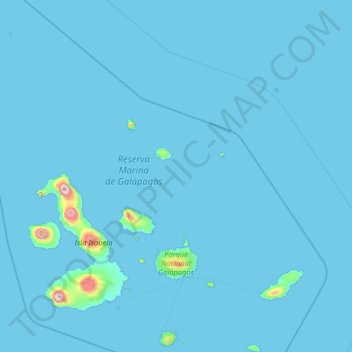
Name: Galapagos Islands topographic map, elevation, terrain.
Location: Galapagos Islands, Galápagos, Ecuador (-1.41157 -92.00919 1.68140 -89.24089)
Average elevation: 17 m
Minimum elevation: 0 m
Maximum elevation: 1,672 m
Other topographic maps
Click on a map to view its topography, its elevation and its terrain.
Isla Plaza Sur
Ecuador > Galápagos > Cantón Santa Cruz
South Plaza (Spanish: Isla Plaza Sur) is a small island off the east coast of Santa Cruz in the Galápagos Islands. It has an area of 0.13 km2 and a maximum altitude of 23 metres.
Average elevation: 5 m
Wolf
Ecuador > Galápagos > Cantón Isabela
Wolf Island (Spanish: Isla Wolf) is a small island in the northern Galápagos Islands. It has an area of 1.3 km2 (0.5 sq mi) and a maximum altitude of 253 m (830 ft) above sea level. The island is remote from the main archipelago and has no permanent population. The Galápagos National Park does not allow…
Average elevation: 15 m
Roca Redonda
Ecuador > Galápagos > Cantón Isabela
Redonda Rock (Spanish: Roca Redonda, "Round Rock") is a flat-topped, steep-sided islet located roughly 25 km (16 mi) northwest of the island of Isabela in Ecuador's Galápagos Islands. Redonda measures 100 m (330 ft) long and 50 m (160 ft) wide with a maximum elevation of 67 m (220 ft). Its isolation and…
Average elevation: 0 m
Isla Pinzón
Ecuador > Galápagos > Cantón Santa Cruz
Pinzón or Pinzon Island (Spanish: Isla Pinzón) is an island in Ecuador's Galápagos Archipelago. It has no permanent population, an area of 18 square kilometers (6.9 sq mi), and a maximum elevation of 458 meters (1,503 ft). Home to giant Galápagos tortoises of the subspecies Chelonoidis duncanensis and…
Average elevation: 124 m
Volcán Darwin
Ecuador > Galápagos > Parroquia Tomas de Berlanga (Santo Tomas)
Average elevation: 1,223 m
Isla Genovesa
Ecuador > Galápagos > Cantón San Cristóbal
Genovesa Island (Spanish: Isla Genovesa), also known as Tower Island, is a shield volcano in the Galápagos Islands in the eastern Pacific Ocean. The island occupies about 14 km2 (5 sq mi), and its maximum elevation is 64 m (210 ft). The horse-shoe shaped island has a volcanic caldera whose wall has collapsed,…
Average elevation: 21 m