
Make a donation
Gear up for your next adventure:
As an Amazon Associate, this site earns from qualifying purchases at no extra cost to you.
Naqadeh County topographic map
Click on the map to display elevation.
Make a donation
Gear up for your next adventure:
As an Amazon Associate, this site earns from qualifying purchases at no extra cost to you.
About this map
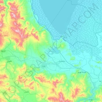
Name: Naqadeh County topographic map, elevation, terrain.
Location: Naqadeh County, West Azerbaijan Province, Iran (36.74920 45.24779 37.32900 45.69317)
Average elevation: 1,480 m
Minimum elevation: 1,264 m
Maximum elevation: 2,537 m
Make a donation
Gear up for your next adventure:
As an Amazon Associate, this site earns from qualifying purchases at no extra cost to you.
Other topographic maps
Click on a map to view its topography, its elevation and its terrain.
Sinabad
Iran > West Azerbaijan Province > Urumia County > دهستان صومای جنوبی
Average elevation: 1,876 m
Make a donation
Gear up for your next adventure:
As an Amazon Associate, this site earns from qualifying purchases at no extra cost to you.
Karimabad
Iran > West Azerbaijan Province > Urumia County > دهستان نازلوشمالی
Average elevation: 1,327 m
Badaki
Iran > West Azerbaijan Province > Chaypareh County > دهستان قره ضیاءالدین
Average elevation: 1,169 m
Make a donation
Gear up for your next adventure:
As an Amazon Associate, this site earns from qualifying purchases at no extra cost to you.
Khalifan, Mahabad
Iran > West Azerbaijan Province > Mahabad County > دهستان کانی بازار
Average elevation: 1,558 m
Sultan Ahmad
Iran > West Azerbaijan Province > Salmas County > دهستان لکستان
Average elevation: 1,298 m
Bedelan
Iran > West Azerbaijan Province > Khoy County > دهستان فیرورق جنوبی
Average elevation: 1,708 m
Make a donation
Gear up for your next adventure:
As an Amazon Associate, this site earns from qualifying purchases at no extra cost to you.
Khorramabad
Iran > West Azerbaijan Province > Urumia County > دهستان باراندوز
Average elevation: 1,379 m
Mamakan
Iran > West Azerbaijan Province > Urumia County > دهستان صومای شمالی
Average elevation: 1,883 m
Make a donation
Gear up for your next adventure:
As an Amazon Associate, this site earns from qualifying purchases at no extra cost to you.
سعیدآباد
Iran > West Azerbaijan Province > Shahin Dezh County > دهستان کشاورز
Average elevation: 1,355 m
Make a donation
Gear up for your next adventure:
As an Amazon Associate, this site earns from qualifying purchases at no extra cost to you.
سیوه کده سفلی
Iran > West Azerbaijan Province > Piranshahr County > دهستان لاهیجان شرقی
Average elevation: 1,978 m
Oshnaviyeh
Iran > West Azerbaijan Province > Oshnavieh County > دهستان اشنویه شمالی
Average elevation: 1,560 m
Make a donation
Gear up for your next adventure:
As an Amazon Associate, this site earns from qualifying purchases at no extra cost to you.
Oshnaviyeh
Iran > West Azerbaijan Province > Oshnavieh County > دهستان اشنویه شمالی
Average elevation: 1,560 m
Khorramabad
Iran > West Azerbaijan Province > Urumia County > دهستان باراندوز
Average elevation: 1,379 m
Make a donation
Gear up for your next adventure:
As an Amazon Associate, this site earns from qualifying purchases at no extra cost to you.
Piranshahr
Iran > West Azerbaijan Province > Piranshahr County > دهستان پیران
Average elevation: 1,536 m
Brisu
Iran > West Azerbaijan Province > Sardasht County > دهستان باسک کولسه
Average elevation: 1,083 m
Make a donation
Gear up for your next adventure:
As an Amazon Associate, this site earns from qualifying purchases at no extra cost to you.
Guyj Ali Tappeh
Iran > West Azerbaijan Province > Urumia County > دهستان باش قلعه
Average elevation: 1,300 m
Chaldran
Iran > West Azerbaijan Province > Chaldoran County > دهستان چالدران شمالی > Chaldran
Average elevation: 1,895 m
Showt
Iran > West Azerbaijan Province > Showt County > دهستان قره قویون شمالی
Average elevation: 1,011 m
Make a donation
Gear up for your next adventure:
As an Amazon Associate, this site earns from qualifying purchases at no extra cost to you.
Malham
Iran > West Azerbaijan Province > Maku County > دهستان چایباسارشمالی
Average elevation: 1,277 m
Make a donation
Gear up for your next adventure:
As an Amazon Associate, this site earns from qualifying purchases at no extra cost to you.
Darin Qaleh
Iran > West Azerbaijan Province > Urumia County > دهستان باراندوزچای جنوبی > Darin Qaleh
Average elevation: 1,625 m
Sadr
Iran > West Azerbaijan Province > Chaldoran County > دهستان چالدران جنوبی > Sadr
Average elevation: 2,304 m
Navai
Iran > West Azerbaijan Province > Khoy County > دهستان گوهران > Navai
Average elevation: 1,078 m
Make a donation
Gear up for your next adventure:
As an Amazon Associate, this site earns from qualifying purchases at no extra cost to you.
Gol Pashin
Iran > West Azerbaijan Province > Urumia County > دهستان بکشلوچای > Gol Pashin
Average elevation: 1,299 m
Make a donation
Gear up for your next adventure:
As an Amazon Associate, this site earns from qualifying purchases at no extra cost to you.