
Midford topographic map
Interactive map
Click on the map to display elevation.
About this map
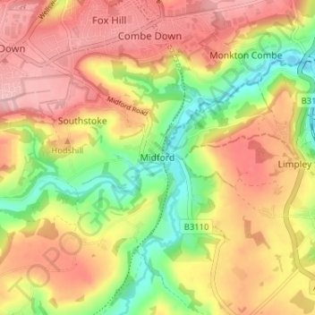
Name: Midford topographic map, elevation, terrain.
Average elevation: 109 m
Minimum elevation: 24 m
Maximum elevation: 179 m
Bath and North East Somerset trails, hiking, mountain biking, running and outdoor activities
Other topographic maps
Click on a map to view its topography, its elevation and its terrain.
Bath
United Kingdom > England > Bath and North East Somerset
Bath is in the Avon Valley and is surrounded by limestone hills as it is near the southern edge of the Cotswolds, a designated Area of Outstanding Natural Beauty, and the limestone Mendip Hills rise around 7 miles (11 km) south of the city. The hills that surround and make up the city have a maximum altitude…
Average elevation: 100 m
Bath
United Kingdom > England > Bath and North East Somerset
Bath is in the Avon Valley and is surrounded by limestone hills as it is near the southern edge of the Cotswolds, a designated Area of Outstanding Natural Beauty, and the Mendip Hills rise around 7 miles (11 km) south of the city. The hills that surround and make up the city have a maximum altitude of 781 feet…
Average elevation: 100 m
Keynsham Memorial Park
United Kingdom > England > Bath and North East Somerset > Keynsham
Average elevation: 29 m
Bath
United Kingdom > England > Bath and North East Somerset
Bath is in the Avon Valley and is surrounded by limestone hills as it is near the southern edge of the Cotswolds, a designated Area of Outstanding Natural Beauty, and the Mendip Hills rise around 7 miles (11 km) south of the city. The hills that surround and make up the city have a maximum altitude of 781 feet…
Average elevation: 100 m
Bath
United Kingdom > England > Bath and North East Somerset
Bath is in the Avon Valley and is surrounded by limestone hills as it is near the southern edge of the Cotswolds, a designated Area of Outstanding Natural Beauty, and the limestone Mendip Hills rise around 7 miles (11 km) south of the city. The hills that surround and make up the city have a maximum altitude…
Average elevation: 100 m
Chew Valley Lake
United Kingdom > England > Bath and North East Somerset > Compton Martin
Average elevation: 67 m
Bath
United Kingdom > England > Bath and North East Somerset
The floodplain of the Avon has an altitude of about 59 ft (18 m) above sea level, although the city centre is at an elevation of around 25 metres (82 ft) above sea level. The river, once an unnavigable series of braided streams broken up by swamps and ponds, has been managed by weirs into a single channel.…
Average elevation: 100 m