
Regional District of Fraser-Fort George topographic map
Interactive map
Click on the map to display elevation.
About this map
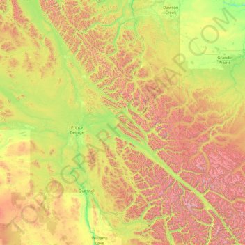
Name: Regional District of Fraser-Fort George topographic map, elevation, terrain.
Average elevation: 1,153 m
Minimum elevation: 340 m
Maximum elevation: 3,719 m
Other topographic maps
Click on a map to view its topography, its elevation and its terrain.
Whistler
Canada > British Columbia > Squamish-Lillooet Regional District > Whistler Resort Municipality > Whistler
Average elevation: 996 m
Grave Island
Canada > British Columbia > Regional District of Mount Waddington > Area A (Seymour Inlet/Knight Inlet)
Average elevation: 9 m
Snow Mountain
Canada > British Columbia > Strathcona Regional District > Area B (Discovery Islands/Mainland Inlets)
Average elevation: 627 m
Copeland Creek
Canada > British Columbia > Columbia-Shuswap Regional District > Area B (Shelter Bay/Mica Creek)
Average elevation: 1,588 m
Sugar Mountain
Canada > British Columbia > Metro Vancouver Regional District > Anmore
Average elevation: 180 m
Sinclair Mills
Canada > British Columbia > Regional District of Fraser-Fort George > Area F (Willow River/Upper Fraser)
Average elevation: 659 m
Kootenay National Park
Canada > British Columbia > Regional District of East Kootenay
Kootenay National Park is a national park of Canada in southeastern British Columbia. The park consists of 1,406 km2 (543 sq mi) of the Canadian Rockies, including parts of the Kootenay and Park mountain ranges, the Kootenay River and the entirety of the Vermilion River. While the Vermilion River is completely…
Average elevation: 1,832 m
Baron Lake
Canada > British Columbia > Regional District of Kitimat-Stikine > Area C (Butedale/Kitlope/Kitsumkalum)
Average elevation: 331 m
Butedale
Canada > British Columbia > Regional District of Kitimat-Stikine > Area C (Butedale/Kitlope/Kitsumkalum)
Average elevation: 265 m
Klemtu
Canada > British Columbia > Regional District of Kitimat-Stikine > Area C (Butedale/Kitlope/Kitsumkalum)
Average elevation: 152 m
Palisade Mountain
Canada > British Columbia > Columbia-Shuswap Regional District > Area A (Kicking Horse/Kinbasket Lake)
Average elevation: 2,361 m
Harry Wipper Park
Canada > British Columbia > Regional District of Nanaimo > Nanaimo
Average elevation: 77 m
Ducie Island
Canada > British Columbia > North Coast Regional District > Area A (North Skeena)
Average elevation: 1 m
Mary's Peak
Canada > British Columbia > Capital Regional District > Juan de Fuca Electoral Area
Average elevation: 458 m
Powder King Peak
Canada > British Columbia > Regional District of Fraser-Fort George > Area G (Crooked River/Parsnip)
Average elevation: 1,381 m
Spruce Lake
Canada > British Columbia > Squamish-Lillooet Regional District > Area A (Upper Bridge River Valley)
Average elevation: 1,688 m
West Bench
Canada > British Columbia > Regional District of Okanagan-Similkameen > Area F (Trout Creek Valley)
Average elevation: 539 m
Wilmer
Canada > British Columbia > Regional District of East Kootenay > Area G (Forster Creek/Mount Assiniboine)
Average elevation: 881 m
Serpentine Lake
Canada > British Columbia > Squamish-Lillooet Regional District > Area B (Cayoosh/Pavilion)
Average elevation: 1,923 m
Strathnaver
Canada > British Columbia > Cariboo Regional District > Area B (Quesnel West/Bouchie Lake)
Average elevation: 715 m
Stuie
Canada > British Columbia > Central Coast Regional District > Area C (Hagensborg/Talchako/Atnarko)
Average elevation: 433 m
Mount Thor
Canada > British Columbia > Regional District of Central Kootenay > Area K (The Arrow Lakes)
Average elevation: 2,222 m
Harrison Mills
Canada > British Columbia > Fraser Valley Regional District > Kent
Average elevation: 54 m
Kettle Lakes
Canada > British Columbia > Regional District of Fraser-Fort George > Area H (Robson Valley/Canoe)
Average elevation: 1,189 m
Capilano Lake
Canada > British Columbia > Metro Vancouver Regional District > West Vancouver
Average elevation: 353 m
Notch Peak
Canada > British Columbia > Peace River Regional District > Area B (Finlay Valley/Beatton Valley)
Average elevation: 1,602 m
Mount Wrottesley
Canada > British Columbia > Sunshine Coast Regional District > Area F (West Howe Sound)
Average elevation: 1,076 m
Furry Creek
Canada > British Columbia > Squamish-Lillooet Regional District > Area D (Elaho/Garibaldi)
Average elevation: 224 m
Mica Peak
Canada > British Columbia > Peace River Regional District > Area B (Finlay Valley/Beatton Valley)
Average elevation: 1,740 m
Hagensborg
Canada > British Columbia > Central Coast Regional District > Area C (Hagensborg/Talchako/Atnarko)
Average elevation: 162 m
Stump Lake
Canada > British Columbia > Regional District of Kootenay Boundary > Area E (Beaverdell/West Boundary)
Average elevation: 1,321 m
Rocky Mountains
Canada > British Columbia > Peace River Regional District > Area D (Kiskatinaw Valley)
Average elevation: 1,458 m
Charles Hill
Canada > British Columbia > Regional District of Mount Waddington > Area A (Seymour Inlet/Knight Inlet)
Average elevation: 87 m
Findlay Creek
Canada > British Columbia > Regional District of East Kootenay > Area F (Columbia Lake/Windermere Lake)
Average elevation: 1,862 m
Submarine Mountain
Canada > British Columbia > Peace River Regional District > Area E (Moberly Lake/Sukunka Valley)
Average elevation: 824 m
Lake O'Hara
Canada > British Columbia > Columbia-Shuswap Regional District > Area A (Kicking Horse/Kinbasket Lake)
Lake O'Hara is a lake at an elevation of 2,020 metres (6,630 ft) in the alpine area of Yoho National Park, in the province of British Columbia, on the western side of the Great Divide with the province of Alberta and Banff National Park to the east. The lake and the valley are accessible through a bus service…
Average elevation: 2,276 m
Winlaw
Canada > British Columbia > Regional District of Central Kootenay > Area H (The Slocan Valley)
Average elevation: 694 m
Woodland Hill
Canada > British Columbia > Thompson-Nicola Regional District > Area L (Grasslands)
Average elevation: 1,385 m
Darke Lake
Canada > British Columbia > Regional District of Okanagan-Similkameen > Area F (Trout Creek Valley)
Average elevation: 1,029 m
Hall Lake
Canada > British Columbia > Regional District of Okanagan-Similkameen > Area H (Manning Park/Tulameen/Siwash)
Average elevation: 1,178 m
Mount Browne
Canada > British Columbia > Regional District of Mount Waddington > Area A (Seymour Inlet/Knight Inlet)
Average elevation: 145 m
Slim Mountain
Canada > British Columbia > Squamish-Lillooet Regional District > Area A (Upper Bridge River Valley)
Average elevation: 2,152 m
Sugarbowl Mountain
Canada > British Columbia > Regional District of Fraser-Fort George > Area F (Willow River/Upper Fraser)
Average elevation: 1,598 m
Dunkley
Canada > British Columbia > Cariboo Regional District > Area B (Quesnel West/Bouchie Lake)
Average elevation: 724 m
Devastator Peak
Canada > British Columbia > Squamish-Lillooet Regional District > Area C (Pemberton Valley/Mount Currie/D'Arcy)
Average elevation: 1,806 m
Durieu
Canada > British Columbia > Fraser Valley Regional District > Area F (McConnell Creek/Hatzic Prairie)
Average elevation: 142 m
Stoney Creek
Canada > British Columbia > Regional District of Central Kootenay > Area K (The Arrow Lakes)
Average elevation: 1,295 m
Yukness Mountain
Canada > British Columbia > Columbia-Shuswap Regional District > Area A (Kicking Horse/Kinbasket Lake)
Average elevation: 2,570 m
Hastings Hill
Canada > British Columbia > Strathcona Regional District > Area B (Discovery Islands/Mainland Inlets)
Average elevation: 181 m
Holberg
Canada > British Columbia > Regional District of Mount Waddington > Area B (Quatsino Sound/Cape Scott)
Average elevation: 150 m
Little Big Horn
Canada > British Columbia > Squamish-Lillooet Regional District > Area A (Upper Bridge River Valley)
Average elevation: 1,986 m
Mount Raleigh
Canada > British Columbia > Strathcona Regional District > Area B (Discovery Islands/Mainland Inlets)
Mount Raleigh, elevation 3,132 m (10,276 ft), is one of the principal summits of the Pacific Ranges of the Coast Mountains of southern British Columbia in Canada. It is located just southeast of the confluence of the Southgate and Bishop Rivers, northeast of the head of Bute Inlet, and is the highest summit…
Average elevation: 2,414 m
Mount Cairnes
Canada > British Columbia > Columbia-Shuswap Regional District > Area A (Kicking Horse/Kinbasket Lake)
Average elevation: 2,493 m
Puma
Canada > British Columbia > Squamish-Lillooet Regional District > Area C (Pemberton Valley/Mount Currie/D'Arcy)
Average elevation: 1,552 m
Lakelse
Canada > British Columbia > Regional District of Kitimat-Stikine > Area C (Butedale/Kitlope/Kitsumkalum)
Average elevation: 213 m
Mount Burwell
Canada > British Columbia > Metro Vancouver Regional District > Electoral Area A
Average elevation: 1,100 m
Mayor Island
Canada > British Columbia > Regional District of Mount Waddington > Area A (Seymour Inlet/Knight Inlet)
Average elevation: 5 m
Monarch Mountain
Canada > British Columbia > Regional District of Mount Waddington > Area A (Seymour Inlet/Knight Inlet)
Average elevation: 2,673 m
Mount Clore
Canada > British Columbia > Regional District of Kitimat-Stikine > Area C (Butedale/Kitlope/Kitsumkalum)
Average elevation: 1,602 m
Pearl Point
Canada > British Columbia > North Coast Regional District > Area A (North Skeena)
Average elevation: 13 m
Nemaiah Valley
Canada > British Columbia > Cariboo Regional District > Area J (West Chilcotin)
Average elevation: 1,270 m
Duffey Lake
Canada > British Columbia > Squamish-Lillooet Regional District > Area B (Cayoosh/Pavilion)
Average elevation: 1,539 m
Stanley Glacier
Canada > British Columbia > Columbia-Shuswap Regional District > Area A (Kicking Horse/Kinbasket Lake)
Average elevation: 2,458 m
Amsbury
Canada > British Columbia > Regional District of Kitimat-Stikine > Area C (Butedale/Kitlope/Kitsumkalum)
Average elevation: 205 m
White Man Pass
Canada > British Columbia > Regional District of East Kootenay > Area F (Columbia Lake/Windermere Lake)
Average elevation: 2,199 m
Mount Erskine
Canada > British Columbia > Capital Regional District > Salt Spring Island Electoral Area
Average elevation: 233 m
Thompson Plateau
Canada > British Columbia > Regional District of Central Okanagan > East Central Okanagan Electoral Area
Average elevation: 1,451 m
Chancellor Peak
Canada > British Columbia > Columbia-Shuswap Regional District > Area A (Kicking Horse/Kinbasket Lake)
Average elevation: 2,366 m
Errington
Canada > British Columbia > Regional District of Nanaimo > Area F (Alberni Highway)
Average elevation: 120 m
Mount Chief Pascall
Canada > British Columbia > Squamish-Lillooet Regional District > Area B (Cayoosh/Pavilion)
Average elevation: 1,817 m
King Peak
Canada > British Columbia > Northern Rockies Regional Municipality
Average elevation: 2,156 m
Heart Lake
Canada > British Columbia > Columbia-Shuswap Regional District > Area B (Shelter Bay/Mica Creek)
Average elevation: 1,968 m
Ryder Lake
Canada > British Columbia > Fraser Valley Regional District > Chilliwack
Average elevation: 255 m
Skook Jim Mountain
Canada > British Columbia > Fraser Valley Regional District > Area C (Sasquatch Country)
Average elevation: 2,216 m
Mount Revelstoke
Canada > British Columbia > Columbia-Shuswap Regional District > Area B (Shelter Bay/Mica Creek)
Average elevation: 1,730 m
Mount Albert
Canada > British Columbia > Sunshine Coast Regional District > Area A (Egmont/Pender Harbour)
Average elevation: 1,938 m
Gun Lake
Canada > British Columbia > Squamish-Lillooet Regional District > Area A (Upper Bridge River Valley)
Average elevation: 1,049 m
Richmond
Canada > British Columbia > Metro Vancouver Regional District > Richmond
Average elevation: 15 m
Forbidden Plateau
Canada > British Columbia > Comox Valley Regional District > Area C (Puntledge/Black Creek)
Average elevation: 1,041 m
McMurdo
Canada > British Columbia > Columbia-Shuswap Regional District > Area A (Kicking Horse/Kinbasket Lake)
Average elevation: 852 m
Nicholson
Canada > British Columbia > Columbia-Shuswap Regional District > Area A (Kicking Horse/Kinbasket Lake)
Average elevation: 861 m
Brooks Falls
Canada > British Columbia > Peace River Regional District > Area E (Moberly Lake/Sukunka Valley)
Average elevation: 1,057 m
Sutton Islets
Canada > British Columbia > Sunshine Coast Regional District > Area A (Egmont/Pender Harbour)
Average elevation: 555 m
Joan Lake
Canada > British Columbia > qathet Regional District > Area A (Malaspina/Toba)
Average elevation: 518 m
Asperity Mountain
Canada > British Columbia > Cariboo Regional District > Area J (West Chilcotin)
Average elevation: 2,990 m
Qualicum Beach
Canada > British Columbia > Regional District of Nanaimo > Qualicum Beach > Qualicum Beach
Average elevation: 47 m