
Make a donation
Gear up for your next adventure:
As an Amazon Associate, this site earns from qualifying purchases at no extra cost to you.
Sunshine Coast topographic map
Click on the map to display elevation.
Make a donation
Gear up for your next adventure:
As an Amazon Associate, this site earns from qualifying purchases at no extra cost to you.
About this map
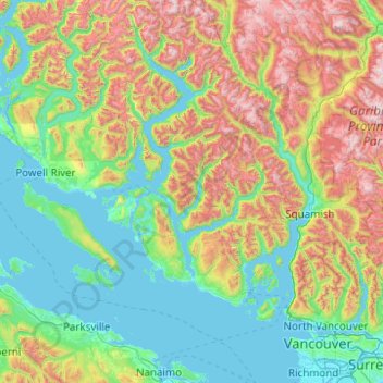
Name: Sunshine Coast topographic map, elevation, terrain.
Location: Sunshine Coast, British Columbia, Canada (49.12508 -124.40445 50.40508 -123.12445)
Average elevation: 649 m
Minimum elevation: -2 m
Maximum elevation: 2,758 m
Make a donation
Gear up for your next adventure:
As an Amazon Associate, this site earns from qualifying purchases at no extra cost to you.
Other topographic maps
Click on a map to view its topography, its elevation and its terrain.
Make a donation
Gear up for your next adventure:
As an Amazon Associate, this site earns from qualifying purchases at no extra cost to you.
Ryder Lake
Canada > British Columbia > Fraser Valley Regional District > Chilliwack
Average elevation: 255 m
Duffey Lake
Canada > British Columbia > Squamish-Lillooet Regional District > Area B (Cayoosh/Pavilion)
Average elevation: 1,539 m
Halfmoon Bay
Canada > British Columbia > Sunshine Coast Regional District > Area B (Halfmoon Bay) > Halfmoon Bay
Average elevation: 16 m
Make a donation
Gear up for your next adventure:
As an Amazon Associate, this site earns from qualifying purchases at no extra cost to you.
Howe Sound
Canada > British Columbia > Sunshine Coast Regional District > Area F (West Howe Sound)
Average elevation: 529 m
Make a donation
Gear up for your next adventure:
As an Amazon Associate, this site earns from qualifying purchases at no extra cost to you.
Seton Lake
Canada > British Columbia > Squamish-Lillooet Regional District > Area B (Cayoosh/Pavilion)
The lake is bounded by snow-capped mountains that descend abruptly to the shores. Environmental conditions largely mirror the Anderson Lake geology, topography, and climate. However, glacial silt from Cayoosh Creek, entering via the power station tunnel, makes the lake water much cloudier than Anderson.
Average elevation: 1,339 m
Yoho National Park
Canada > British Columbia > Columbia-Shuswap Regional District
The weather in the park is localized and changeable. Located on the western side of the continental divide, it receives more precipitation than areas east of the divide. Precipitation in the park increases with elevation. In winter, average temperatures are between 5 and −15 °C (41.0 and 5.0 °F) from the…
Average elevation: 1,934 m
Kettle Lakes
Canada > British Columbia > Regional District of Fraser-Fort George > Area H (Robson Valley/Canoe)
Average elevation: 1,189 m
Make a donation
Gear up for your next adventure:
As an Amazon Associate, this site earns from qualifying purchases at no extra cost to you.
Darke Lake
Canada > British Columbia > Regional District of Okanagan-Similkameen > Area F (Trout Creek Valley)
Average elevation: 1,029 m
Moose Lake
Canada > British Columbia > Cariboo Regional District > Area G (Lac La Hache/108 Mile Ranch)
Average elevation: 1,176 m
Make a donation
Gear up for your next adventure:
As an Amazon Associate, this site earns from qualifying purchases at no extra cost to you.
Area J (Copper Desert Country)
Canada > British Columbia > Thompson-Nicola Regional District
Average elevation: 1,128 m
Garibaldi Lake
Canada > British Columbia > Squamish-Lillooet Regional District > Area D (Elaho/Garibaldi)
All recreational activities in the area are governed by the regulations of Garibaldi Provincial Park. Primary access to the lake is via the 9 km (5.6 mi) long Garibaldi Lake Trail, which gains approximately 920 m (3,020 ft) of elevation from the Rubble Creek Trailhead. There are campgrounds and day-use…
Average elevation: 1,620 m
Make a donation
Gear up for your next adventure:
As an Amazon Associate, this site earns from qualifying purchases at no extra cost to you.
Moberly Lake
Canada > British Columbia > Peace River Regional District > Area E (Moberly Lake/Sukunka Valley)
Average elevation: 886 m
Kootenay National Park
Canada > British Columbia > Regional District of East Kootenay
Kootenay National Park is a national park of Canada in southeastern British Columbia. The park consists of 1,406 km2 (543 sq mi) of the Canadian Rockies, including parts of the Kootenay and Park mountain ranges, the Kootenay River and the entirety of the Vermilion River. While the Vermilion River is completely…
Average elevation: 1,832 m
Baron Lake
Canada > British Columbia > Regional District of Kitimat-Stikine > Area C (Butedale/Kitlope/Kitsumkalum)
Average elevation: 331 m
Area D (Iskut/Big Raven)
Canada > British Columbia > Regional District of Kitimat-Stikine
Average elevation: 1,172 m
Make a donation
Gear up for your next adventure:
As an Amazon Associate, this site earns from qualifying purchases at no extra cost to you.
Area C (Bowron Lake/Barlow Creek/Barkerville)
Canada > British Columbia > Cariboo Regional District
Average elevation: 1,399 m
Make a donation
Gear up for your next adventure:
As an Amazon Associate, this site earns from qualifying purchases at no extra cost to you.
Area B (Halfmoon Bay)
Canada > British Columbia > Sunshine Coast Regional District
Average elevation: 464 m
Spruce Lake
Canada > British Columbia > Squamish-Lillooet Regional District > Area A (Upper Bridge River Valley)
Average elevation: 1,688 m
Make a donation
Gear up for your next adventure:
As an Amazon Associate, this site earns from qualifying purchases at no extra cost to you.
Crooked River Provincial Park
Canada > British Columbia > Regional District of Fraser-Fort George > Area G (Crooked River/Parsnip) > Bear Lake
Average elevation: 716 m
Ducie Island
Canada > British Columbia > North Coast Regional District > Area A (North Skeena)
Average elevation: 1 m
Area A (Wynndel/Crawford Bay/Riondel)
Canada > British Columbia > Regional District of Central Kootenay
Average elevation: 1,574 m
Make a donation
Gear up for your next adventure:
As an Amazon Associate, this site earns from qualifying purchases at no extra cost to you.
Harrison Hot Springs
Canada > British Columbia > Fraser Valley Regional District
Average elevation: 203 m
Hatzic Lake
Canada > British Columbia > Fraser Valley Regional District > Area G (Deroche/Dewdney/Sumas Mountain)
Average elevation: 43 m
Harrison Lake
Canada > British Columbia > Fraser Valley Regional District > Area C (Sasquatch Country)
Average elevation: 815 m
Capilano Lake
Canada > British Columbia > Metro Vancouver Regional District > West Vancouver
Average elevation: 353 m
Make a donation
Gear up for your next adventure:
As an Amazon Associate, this site earns from qualifying purchases at no extra cost to you.
Wells
Canada > British Columbia > Cariboo Regional District
Wells doesn't have a weather station, but Barkerville does (located 7 km (4.3 mi) away). Wells has a subarctic climate (Köppen climate classification Dfc), resulting in long, cold and snowy winters, accompanied by short and cool summers due to its high altitude and latitude. Its growing season averages only…
Average elevation: 1,439 m
Serpentine Lake
Canada > British Columbia > Squamish-Lillooet Regional District > Area B (Cayoosh/Pavilion)
Average elevation: 1,923 m
Make a donation
Gear up for your next adventure:
As an Amazon Associate, this site earns from qualifying purchases at no extra cost to you.
Lelu Island
Canada > British Columbia > North Coast Regional District > Port Edward
Average elevation: 23 m
Harry Wipper Park
Canada > British Columbia > Regional District of Nanaimo > Nanaimo
Average elevation: 77 m
Boyle Rocks
Canada > British Columbia > Central Coast Regional District > Area A (Ocean Falls/Outer Coast)
Average elevation: 5 m
Dunbar-Southlands
Canada > British Columbia > Metro Vancouver Regional District > Vancouver
Average elevation: 43 m
Make a donation
Gear up for your next adventure:
As an Amazon Associate, this site earns from qualifying purchases at no extra cost to you.
Copeland Creek
Canada > British Columbia > Columbia-Shuswap Regional District > Area B (Shelter Bay/Mica Creek)
Average elevation: 1,588 m
Grave Island
Canada > British Columbia > Regional District of Mount Waddington > Area A (Seymour Inlet/Knight Inlet)
Average elevation: 9 m
Trail
Canada > British Columbia > Regional District of Kootenay Boundary
Summer climate in Trail is generally hot and dry with moderately cool nights. Temperatures often exceed 35 °C (95 °F) during summer afternoons, average 29 °C (84 °F). Thunderstorms are common during the late-Spring and Summer season, often moving into the valley from the south. The fall months bring dense…
Average elevation: 888 m
Little Big Horn
Canada > British Columbia > Squamish-Lillooet Regional District > Area A (Upper Bridge River Valley)
Average elevation: 1,986 m
Make a donation
Gear up for your next adventure:
As an Amazon Associate, this site earns from qualifying purchases at no extra cost to you.
Area B (Lazo North)
Canada > British Columbia > Comox Valley Regional District
Average elevation: 11 m
Mellin Lake
Canada > British Columbia > Thompson-Nicola Regional District > Area M (Beautiful Nicola Valley - North)
Average elevation: 1,441 m
Stump Lake
Canada > British Columbia > Regional District of Kootenay Boundary > Area E (Beaverdell/West Boundary)
Average elevation: 1,321 m
Rithet's Bog Conservation Area
Canada > British Columbia > Capital Regional District > Saanich
Average elevation: 44 m
Make a donation
Gear up for your next adventure:
As an Amazon Associate, this site earns from qualifying purchases at no extra cost to you.
Area A (Hudson Bay Mountain)
Canada > British Columbia > Regional District of Bulkley-Nechako
Average elevation: 1,108 m
Findlay Creek
Canada > British Columbia > Regional District of East Kootenay > Area F (Columbia Lake/Windermere Lake)
Average elevation: 1,862 m
University of British Columbia
Canada > British Columbia > Metro Vancouver Regional District > Electoral Area A
Average elevation: 58 m
Area D (Kiskatinaw Valley)
Canada > British Columbia > Peace River Regional District
Average elevation: 1,024 m
Make a donation
Gear up for your next adventure:
As an Amazon Associate, this site earns from qualifying purchases at no extra cost to you.
Area F (McConnell Creek/Hatzic Prairie)
Canada > British Columbia > Fraser Valley Regional District
Average elevation: 832 m
Ruth Lake
Canada > British Columbia > Cariboo Regional District > Area H (Canim Lake/Forest Grove)
Average elevation: 912 m
Make a donation
Gear up for your next adventure:
As an Amazon Associate, this site earns from qualifying purchases at no extra cost to you.
Dragon Mountain Provincial Park
Canada > British Columbia > Cariboo Regional District > Area A (Red Bluff/Quesnel South)
Average elevation: 877 m
Lazo Marsh-North East Comox Wildlife Management Area
Canada > British Columbia > Comox Valley Regional District > Area B (Lazo North)
Average elevation: 21 m
Area A (Seymour Inlet/Knight Inlet)
Canada > British Columbia > Regional District of Mount Waddington
Average elevation: 969 m
Hall Lake
Canada > British Columbia > Regional District of Okanagan-Similkameen > Area H (Manning Park/Tulameen/Siwash)
Average elevation: 1,178 m
Make a donation
Gear up for your next adventure:
As an Amazon Associate, this site earns from qualifying purchases at no extra cost to you.
Ness Islands
Canada > British Columbia > North Coast Regional District > Area C (South Skeena)
Average elevation: 1 m
Louise Lake
Canada > British Columbia > Regional District of Bulkley-Nechako > Area A (Hudson Bay Mountain)
Average elevation: 1,033 m
Area C (Butedale/Kitlope/Kitsumkalum)
Canada > British Columbia > Regional District of Kitimat-Stikine
Average elevation: 639 m
Make a donation
Gear up for your next adventure:
As an Amazon Associate, this site earns from qualifying purchases at no extra cost to you.
Area C (Chilako River/Nechako)
Canada > British Columbia > Regional District of Fraser-Fort George
Average elevation: 808 m
Ksi X'anmaas Conservancy
Canada > British Columbia > Regional District of Kitimat-Stikine > Area A (Nass Valley/Bell Irving)
Average elevation: 654 m
Okanagan Lake
Canada > British Columbia > Regional District of Central Okanagan > Kelowna
Average elevation: 1,194 m
Area A (Egmont/Pender Harbour)
Canada > British Columbia > Sunshine Coast Regional District
Average elevation: 849 m
Make a donation
Gear up for your next adventure:
As an Amazon Associate, this site earns from qualifying purchases at no extra cost to you.
Lighthouse Park
Canada > British Columbia > Metro Vancouver Regional District > West Vancouver
The sword fern (Polystichum munitum), one of the most abundant ferns in North America, can be found from Alaska to California and is named for its small upward-pointing lobe that resembles a sword hilt. This fern prefers to grow in moist, coniferous low elevation environments but can survive dry periods.…
Average elevation: 22 m
Nimmo Bay
Canada > British Columbia > Regional District of Mount Waddington > Area A (Seymour Inlet/Knight Inlet)
Average elevation: 78 m
Make a donation
Gear up for your next adventure:
As an Amazon Associate, this site earns from qualifying purchases at no extra cost to you.
Mayor Island
Canada > British Columbia > Regional District of Mount Waddington > Area A (Seymour Inlet/Knight Inlet)
Average elevation: 5 m
Make a donation
Gear up for your next adventure:
As an Amazon Associate, this site earns from qualifying purchases at no extra cost to you.
K'Mooda/Lowe-Gamble Conservancy
Canada > British Columbia > North Coast Regional District > Area C (South Skeena)
Average elevation: 251 m
Sun Peaks Mountain Resort Municipality
Canada > British Columbia > Thompson-Nicola Regional District
Average elevation: 1,589 m
Juan de Fuca Electoral Area
Canada > British Columbia > Capital Regional District > Juan de Fuca Electoral Area
Average elevation: 255 m
Make a donation
Gear up for your next adventure:
As an Amazon Associate, this site earns from qualifying purchases at no extra cost to you.
Area C (Sasquatch Country)
Canada > British Columbia > Fraser Valley Regional District
Average elevation: 988 m
Tŝilhqox Biny (Chilko Lake)
Canada > British Columbia > Cariboo Regional District > Area J (West Chilcotin)
Tŝilhqox Biny (Pronounced: Tsyle-koh Bee), known as Chilko Lake, is a 180 km2 lake in west-central British Columbia, at the head of the Chilko River on the Chilcotin Plateau. The lake is about 65 km long, with a southwest arm 10 km long. It is one of the largest lakes by volume in the province because of its…
Average elevation: 1,738 m
Area D (Nimpkish Valley/Cormorant Island)
Canada > British Columbia > Regional District of Mount Waddington
Average elevation: 536 m
Make a donation
Gear up for your next adventure:
As an Amazon Associate, this site earns from qualifying purchases at no extra cost to you.
Area E (Moberly Lake/Sukunka Valley)
Canada > British Columbia > Peace River Regional District
Average elevation: 1,025 m
Salt Spring Island Electoral Area
Canada > British Columbia > Capital Regional District
Average elevation: 64 m
Lake Country
Canada > British Columbia > Regional District of Central Okanagan
Average elevation: 650 m
Make a donation
Gear up for your next adventure:
As an Amazon Associate, this site earns from qualifying purchases at no extra cost to you.