
Wallis topographic map
Interactive map
Click on the map to display elevation.
Wallis
Valais is the highest canton in terms of absolute, relative, and mean elevation. Therefore, its topography is extremely rugged, with the notable exception of the wide, glacial, Rhône valley. The latter valley dominates the geography of the canton. Many side valleys are branching off the main valley, often perpendicularly. These vary from narrow and remote to reasonably populous. On the south side of the Rhône, in the Valais Alps, some of the largest side valleys are (from east to west): the Mattertal (including the Saastal), the Val d'Anniviers, the Val d'Hérens, the Val de Bagnes and the Val d'Entremont. On the north of the Rhône, in the Bernese Alps, the Lötschental is the only large valley. East of Brig is the valley of Goms, the highest section of the Rhône Valley. The Rhône itself flows in the main valley from east to west from the Rhône Glacier down to Martigny, then at a right angle north to its mouth in Lake Geneva. After the town of Saint-Maurice, the eastern banks of the river belong to the canton of Vaud, although the western banks remain in Valais, down to Le Bouveret, on the shores of Lake Geneva. The main valley is bounded by the Bernese Alps in the north and the Valais Alps in the south, both ranges including numerous over 4,000 metre-high mountains, which are the highest in the country. Notables mountains include Monte Rosa (highest), reaching 4,634 metres (15,203 ft), and the Finsteraarhorn (most prominent), reaching 4,274 metres (14,022 ft). Other iconic mountains are the Matterhorn and the Jungfrau, for a complete list, see list of mountains of Valais. Located there are numerous glaciers including several of the largest in the Alps, such as the Aletsch Glacier and the Gorner Glacier. Other ranges situated partially in Valais are the Chablais Alps, the Mont Blanc Massif, the Uri Alps, the Gotthard Massif, and the Lepontine Alps.
About this map
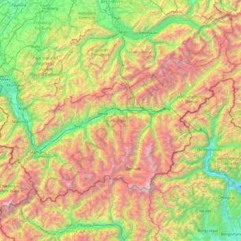
Name: Wallis topographic map, elevation, terrain.
Location: Wallis, Switzerland (45.85831 6.77063 46.65405 8.47856)
Average elevation: 1,728 m
Minimum elevation: 190 m
Maximum elevation: 4,728 m
Other topographic maps
Click on a map to view its topography, its elevation and its terrain.
Sigriswiler Rothorn
Switzerland > Bern > Thun administrative district > Sigriswil
Average elevation: 1,552 m
Faulensee
Switzerland > Bern > Frutigen-Niedersimmental administrative district > Spiez
Average elevation: 638 m
Le Crêt
Switzerland > Vaud > District de la Riviera-Pays-d’Enhaut > Rougemont
Average elevation: 1,229 m
Fürten
Switzerland > Bern > Frutigen-Niedersimmental administrative district > Kandergrund
Average elevation: 1,402 m
Eiger
Switzerland > Bern > Interlaken-Oberhasli administrative district > Grindelwald
Average elevation: 2,944 m
Triftsee
Switzerland > Bern > Interlaken-Oberhasli administrative district > Innertkirchen
Average elevation: 2,025 m
Schwarzhoren
Switzerland > Bern > Interlaken-Oberhasli administrative district > Grindelwald
Average elevation: 2,468 m
Piz Linard
Switzerland > Grisons > Region Engiadina Bassa/Val Müstair > Zernez
Average elevation: 2,626 m
Rheinquelle
Switzerland > Grisons > Surselva > Tujetsch
The Swiss Federal Office of Topography and ETH Zürich indicate a point north of Lake Toma and the Rein da Tuma as the source of the Rhine (and also of the Vorderrhein), and as the source of the Hinterrhein a point in the upper valley of the Rheinwald, east of the Rheinwaldhorn.
Average elevation: 2,435 m
Underburg
Switzerland > Bern > Interlaken-Oberhasli administrative district > Innertkirchen > Wychel
Average elevation: 912 m
Passo dell'Alpe di Neggia
Switzerland > Ticino > Distretto di Locarno > Gambarogno > Rii
Average elevation: 1,319 m
Haslemer Weier
Switzerland > Schaffhausen > Bezirk Unterklettgau > Osterfingen > Gwelb
Average elevation: 437 m
Oberwald
Switzerland > Wallis > Goms > Obergoms
It is situated at an elevation of 1,377 m and had a population of 277 in December 2007. It is located at the end of the Goms, directly before the Furka and Grimsel passes, underneath the Rhône River source at the Rhône Glacier. It is also the startpoint of the Furka Tunnel and is served by Oberwald railway…
Average elevation: 1,744 m
Jungfraujoch
Switzerland > Bern > Interlaken-Oberhasli administrative district > Lauterbrunnen
The Jungfraujoch (German: lit. "maiden saddle") is a saddle connecting two major 4000ers of the Bernese Alps: the Jungfrau and the Mönch. It lies at an elevation of 3,463 metres (11,362 ft) above sea level and is directly overlooked by the rocky prominence of the Sphinx. The Jungfraujoch is a glacier saddle,…
Average elevation: 3,307 m
Jungfrau
Switzerland > Bern > Interlaken-Oberhasli administrative district > Lauterbrunnen
The difference of altitude between the deep valley of Lauterbrunnen (800 m or 2,600 ft) and the summit is particularly visible from the area of Mürren. From the valley floor, west of the massif, the altitude gain is more than 3 km (1.9 mi) for a horizontal distance of 4 km (2.5 mi).
Average elevation: 3,401 m
Jungfraujoch
Switzerland > Bern > Interlaken-Oberhasli administrative district > Lauterbrunnen
The Jungfraujoch (German: lit. "maiden saddle") is a saddle connecting two major 4000ers of the Bernese Alps: the Jungfrau and the Mönch. It lies at an elevation of 3,463 metres (11,362 ft) above sea level and is directly overlooked by the rocky prominence of the Sphinx. The Jungfraujoch is a glacier saddle,…
Average elevation: 3,307 m
Gantrisch
Switzerland > Bern > Bern-Mittelland administrative district > Rüeggisberg
Average elevation: 1,776 m
Harderkulm
Switzerland > Bern > Interlaken-Oberhasli administrative district > Unterseen
Average elevation: 891 m
Schilthorn
Switzerland > Bern > Interlaken-Oberhasli administrative district > Lauterbrunnen
Average elevation: 2,455 m
Kiental
Switzerland > Bern > Frutigen-Niedersimmental administrative district > Reichenbach im Kandertal
Since 1910, the nearby mountain of Niesen (altitude 2,362 m [7,749 ft]) can be ascended at gradients of up to 68% via the Niesenbahn, which with a length of 3,499 m (11,480 ft) is the longest funicular railway in Europe.
Average elevation: 1,509 m
Möösli
Switzerland > Bern > Interlaken-Oberhasli administrative district > Interlaken
Average elevation: 674 m
Oberwald
Switzerland > Wallis > Goms > Obergoms
It is situated at an elevation of 1,377 m and had a population of 277 in December 2007. It is located at the end of the Goms, directly before the Furka and Grimsel passes, underneath the Rhône River source at the Rhône Glacier. It is also the startpoint of the Furka Tunnel and is served by Oberwald railway…
Average elevation: 1,744 m
ewl Ausgleichsbecken Untertrübsee
Switzerland > Nidwalden > Wolfenschiessen
Average elevation: 1,458 m