
Make a donation
Gear up for your next adventure:
As an Amazon Associate, this site earns from qualifying purchases at no extra cost to you.
Socorro County topographic map
Click on the map to display elevation.
Make a donation
Gear up for your next adventure:
As an Amazon Associate, this site earns from qualifying purchases at no extra cost to you.
Socorro County
A mining rush followed the Apache wars – gold, silver, and copper were found in the mountains. It wasn't until this time that extensive use of the area by non-Native Americans occurred. While some mining activity, involving gold, silver, and copper, occurred in the southern part of the range near the end of the nineteenth century, the prospecting/mining remnants are barely visible today due to collapse, topographic screening, and vegetation regrowth. While miners combed the mountains for mineral riches during the late nineteenth and early twentieth centuries, stockmen drove tens of thousands of sheep and cattle to stockyards at the village of Magdalena, then linked by rail with Socorro. In fact, the last regularly used cattle trail in the United States stretched 125 miles westward from Magdalena. The route was formally known as the Magdalena Livestock Driveway, but more popularly known to cowboys and cattlemen as the Beefsteak Trail. The trail began use in 1865 and its peak was in 1919. The trail was used continually until trailing gave way to trucking and the trail officially closed in 1971.
Make a donation
Gear up for your next adventure:
As an Amazon Associate, this site earns from qualifying purchases at no extra cost to you.
About this map
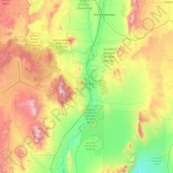
Name: Socorro County topographic map, elevation, terrain.
Location: Socorro County, New Mexico, United States (33.47528 -107.72672 34.58061 -105.92378)
Average elevation: 1,830 m
Minimum elevation: 1,238 m
Maximum elevation: 3,190 m
Make a donation
Gear up for your next adventure:
As an Amazon Associate, this site earns from qualifying purchases at no extra cost to you.
Other topographic maps
Click on a map to view its topography, its elevation and its terrain.
Truchas
United States > New Mexico > Rio Arriba County
On March 18, 1754, New Mexican governor Tomás Vélez Cachupin awarded the Nuestro Señora del Rosario, San Fernando y Santiago del Rio de las Truchas Grant, to eleven residents of the nearby settlements of Chimayo and Pueblo Quemado. The grantees had asserted their claim to the area of the grant during the…
Average elevation: 2,424 m
Albuquerque
United States > New Mexico > Bernalillo County
Albuquerque is located in north-central New Mexico. To its east are the Sandia–Manzano Mountains. The Rio Grande flows north to south through its center, while the West Mesa and Petroglyph National Monument make up the western part of the city. Albuquerque has one of the highest elevations of any major city…
Average elevation: 1,671 m
Make a donation
Gear up for your next adventure:
As an Amazon Associate, this site earns from qualifying purchases at no extra cost to you.
Make a donation
Gear up for your next adventure:
As an Amazon Associate, this site earns from qualifying purchases at no extra cost to you.
Make a donation
Gear up for your next adventure:
As an Amazon Associate, this site earns from qualifying purchases at no extra cost to you.
Albuquerque
United States > New Mexico > Bernalillo County
Albuquerque is located in north-central New Mexico. To its east are the Sandia–Manzano Mountains. The Rio Grande flows north to south through its center, while the West Mesa and Petroglyph National Monument make up the western part of the city. Albuquerque has one of the highest elevations of any major city…
Average elevation: 1,671 m
Make a donation
Gear up for your next adventure:
As an Amazon Associate, this site earns from qualifying purchases at no extra cost to you.
White Sands Missile Range
United States > New Mexico > Doña Ana County > White Sands
Average elevation: 1,306 m
Make a donation
Gear up for your next adventure:
As an Amazon Associate, this site earns from qualifying purchases at no extra cost to you.
Albuquerque
United States > New Mexico > Bernalillo County
Albuquerque is located in north-central New Mexico. To its east are the Sandia–Manzano Mountains. The Rio Grande flows north to south through its center, while the West Mesa and Petroglyph National Monument make up the western part of the city. Albuquerque has one of the highest elevations of any major city…
Average elevation: 1,671 m
Make a donation
Gear up for your next adventure:
As an Amazon Associate, this site earns from qualifying purchases at no extra cost to you.
Dominguez-Velez de Escalente Trail Historical Marker
United States > New Mexico > Rio Arriba County > Abiquiu > El Curuco
Average elevation: 1,877 m
Make a donation
Gear up for your next adventure:
As an Amazon Associate, this site earns from qualifying purchases at no extra cost to you.
High Rolls
United States > New Mexico > Otero County
The first official use of the High Rolls name was in 1901, when the post office was moved from Fresnal (Wooten) to High Rolls. The name, which was sometimes spelled as one word, Highrolls, supposedly came from the shape and elevation of the area as compared to the sharper peaks higher up.
Average elevation: 2,036 m
Rio Grande Rift Historical Marker
United States > New Mexico > Cibola County > Laguna
Average elevation: 1,782 m
Make a donation
Gear up for your next adventure:
As an Amazon Associate, this site earns from qualifying purchases at no extra cost to you.
White Sands Missile Range
United States > New Mexico > Doña Ana County > White Sands
Average elevation: 1,306 m
Make a donation
Gear up for your next adventure:
As an Amazon Associate, this site earns from qualifying purchases at no extra cost to you.
Make a donation
Gear up for your next adventure:
As an Amazon Associate, this site earns from qualifying purchases at no extra cost to you.
Make a donation
Gear up for your next adventure:
As an Amazon Associate, this site earns from qualifying purchases at no extra cost to you.
Winterwood Park (HOA)
United States > New Mexico > Bernalillo County > Albuquerque
Average elevation: 1,770 m
Make a donation
Gear up for your next adventure:
As an Amazon Associate, this site earns from qualifying purchases at no extra cost to you.
Make a donation
Gear up for your next adventure:
As an Amazon Associate, this site earns from qualifying purchases at no extra cost to you.
San Antonio Mountain
United States > New Mexico > Rio Arriba County
San Antonio Mountain is a free-standing volcanic peak in Rio Arriba County, New Mexico. With an elevation of 10,908 feet, San Antonio Mountain is the highest peak within the Taos Plateau volcanic field, the largest volcanic field within the Rio Grande Rift valley.
Average elevation: 3,182 m
High Rolls
United States > New Mexico > Otero County
The first official use of the High Rolls name was in 1901, when the post office was moved from Fresnal (Wooten) to High Rolls. The name, which was sometimes spelled as one word, Highrolls, supposedly came from the shape and elevation of the area as compared to the sharper peaks higher up.
Average elevation: 2,036 m
Make a donation
Gear up for your next adventure:
As an Amazon Associate, this site earns from qualifying purchases at no extra cost to you.
Dixon
United States > New Mexico > Rio Arriba County
Dixon is an unincorporated community located in Rio Arriba County, New Mexico, United States, on New Mexico State Road 75, just east of New Mexico State Road 68, in the north-central part of the state, and is approximately 20 miles (32 km) southwest of Taos. The elevation of Dixon is 6,028 feet (1,837 m) above…
Average elevation: 1,878 m
Make a donation
Gear up for your next adventure:
As an Amazon Associate, this site earns from qualifying purchases at no extra cost to you.
Eastrange-Piedra Vista
United States > New Mexico > Bernalillo County > Albuquerque
Average elevation: 1,839 m
Make a donation
Gear up for your next adventure:
As an Amazon Associate, this site earns from qualifying purchases at no extra cost to you.
Arroyo Seco
United States > New Mexico > Taos County
Arroyo Seco has a post office, with the ZIP code 87514. The 87514 ZIP Code Tabulation Area had a population of 1,310 at the 2000 census, with 996 housing units, a land area of 53.63 sq. miles, a water area of 0.05 sq. mile, and a population density of 24.43 people per sq. mile at Census 2000. Arroyo Seco's…
Average elevation: 2,338 m
Sandia Mountains Historical Marker
United States > New Mexico > Bernalillo County
Average elevation: 2,938 m
Make a donation
Gear up for your next adventure:
As an Amazon Associate, this site earns from qualifying purchases at no extra cost to you.
Tres Piedras
United States > New Mexico > Taos County
Tres Piedras is located approximately 30 miles northwest of Taos, and west of the Rio Grande on U.S. Route 64. At approximately 8,000 feet (2,400 m) in altitude, it is located within the southern portion of the San Juan Range of the Rocky Mountains. Tres Piedras is on the western edge of a sagebrush plain,…
Average elevation: 2,476 m
Tierra Amarilla
United States > New Mexico > Rio Arriba County
The Brazos Cliffs are a prominent nearby landmark and attraction. Also nearby are the artificial Heron Lake and El Vado Lake. Tierra Amarilla's elevation is 7,524 feet above sea level.
Average elevation: 2,318 m
Make a donation
Gear up for your next adventure:
As an Amazon Associate, this site earns from qualifying purchases at no extra cost to you.
El Paso Natural Gas Dam Number 5
United States > New Mexico > San Juan County > Kirtland
Average elevation: 1,604 m
Make a donation
Gear up for your next adventure:
As an Amazon Associate, this site earns from qualifying purchases at no extra cost to you.
Vista Del Mundo
United States > New Mexico > Bernalillo County > Albuquerque
Average elevation: 1,903 m
Make a donation
Gear up for your next adventure:
As an Amazon Associate, this site earns from qualifying purchases at no extra cost to you.
Make a donation
Gear up for your next adventure:
As an Amazon Associate, this site earns from qualifying purchases at no extra cost to you.
Wheeler Peak
United States > New Mexico > Taos County
Wheeler Peak is the highest natural point in the U.S. state of New Mexico. It is located northeast of Taos and south of Red River in the northern part of the state, and just 2 miles (3.2 km) southeast of the ski slopes of Taos Ski Valley. It lies in the Sangre de Cristo Mountains, the southernmost subrange of…
Average elevation: 3,674 m
Make a donation
Gear up for your next adventure:
As an Amazon Associate, this site earns from qualifying purchases at no extra cost to you.
Clayton Lake State Park and Dinosaur Trackways
United States > New Mexico > Union County
Average elevation: 1,606 m
Make a donation
Gear up for your next adventure:
As an Amazon Associate, this site earns from qualifying purchases at no extra cost to you.
Española
United States > New Mexico > Rio Arriba County
Española lies at an elevation of around 5,595 feet (1,705 m) with much variance. It is in a valley nestled between the Jemez and Sangre de Cristo mountain ranges, and the meeting point of three rivers, the Rio Grande, the Rio Chama, and the Rio Santa Cruz.
Average elevation: 1,750 m
Make a donation
Gear up for your next adventure:
As an Amazon Associate, this site earns from qualifying purchases at no extra cost to you.
Make a donation
Gear up for your next adventure:
As an Amazon Associate, this site earns from qualifying purchases at no extra cost to you.