
Skiddaw topographic map
Interactive map
Click on the map to display elevation.
Skiddaw
The Northern Fells make up a roughly circular upland area approaching 10 miles (16 kilometres) in width. At the centre is the marshy depression of Skiddaw Forest, a treeless plateau, or valley, at an elevation of about 400 metres (1,300 feet); flowing outwards from here are the rivers that divide the area into three sectors. The south-western sector, between the Glenderaterra Beck and Dash Beck, contains Skiddaw and its satellites.
About this map
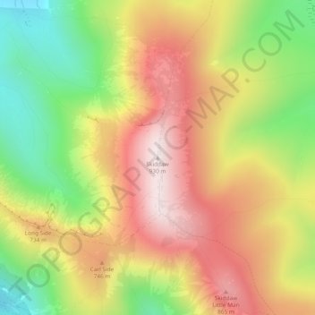
Name: Skiddaw topographic map, elevation, terrain.
Location: Skiddaw, Cumberland, England, CA12 4QX, United Kingdom (54.65134 -3.14782 54.65144 -3.14772)
Average elevation: 630 m
Minimum elevation: 312 m
Maximum elevation: 922 m
Cumberland trails, hiking, mountain biking, running and outdoor activities
Other topographic maps
Click on a map to view its topography, its elevation and its terrain.
Crinkle Crags
United Kingdom > England > Cumberland > Ulpha
In recent times more systematic hill lists have been produced based upon topographical prominence and height, rather than mere visual appeal. Most relevant to Crinkle Crags are the lists of Hewitts and Nuttalls. These variously list the summit, the first Crinkle (Crinkle Crags South Top), and two tops on…
Average elevation: 566 m
Burnmoor Tarn
United Kingdom > England > Cumberland
The tarn is one of the sites in DEFRA's UK Upland Waters Monitoring Network. It occupies 23.9 hectares (59 acres) and lies at an altitude of 253 metres (830 ft) in a moraine hollow on the uplands between Wastwater and Eskdale. The lake has two distinct basins close to the south-eastern shore and a maximum…
Average elevation: 345 m
Blindcrake
United Kingdom > England > Cumberland
The Isel valley has a temperate climate like much of the UK. However, it is one of the driest and sunniest parts of the Lake District. Summers are typically warm with some rain, with late spring to mid-summer tending to be the driest time of the year. Winters can be mild and wet, but due to the areas…
Average elevation: 131 m
Cockermouth
United Kingdom > England > Cumberland
Cockermouth has a temperate climate that is influenced by the Irish Sea and its low-lying elevation. Cockermouth receives slightly below average rainfall compared with the UK average. Temperatures are also round about average compared with other parts of the UK. The nearest weather station for which online…
Average elevation: 86 m