
Loweswater topographic map
Interactive map
Click on the map to display elevation.
About this map
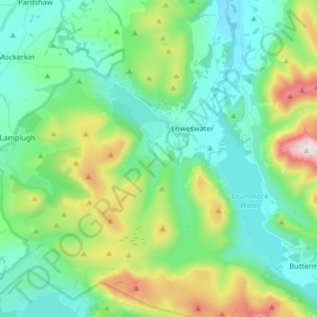
Name: Loweswater topographic map, elevation, terrain.
Location: Loweswater, Cumberland, England, United Kingdom (54.52745 -3.42319 54.61113 -3.28005)
Average elevation: 273 m
Minimum elevation: 73 m
Maximum elevation: 851 m
Other topographic maps
Click on a map to view its topography, its elevation and its terrain.
Scafell Pike
United Kingdom > England > Cumberland
Scafell Pike (/ˈskɔːfɛl paɪk/) is the highest and the most prominent mountain in England, at an elevation of 978 metres (3,209 ft) above sea level. It is located in the Lake District National Park, in Cumbria, and is part of the Southern Fells and the Scafell massif.
Average elevation: 679 m
High Stile (Wainwright summit)
United Kingdom > England > Cumberland > Buttermere
Average elevation: 435 m
High Rigg
United Kingdom > England > Cumberland
High Rigg is a small fell located in the English Lake District, approximately three miles southeast of the town of Keswick. It occupies an unusual position, surrounded on all sides by higher fells but not connected by any obvious ridge. This separation from its fellows ensures that it is a Marilyn (a hill with…
Average elevation: 204 m
Burnmoor Tarn
United Kingdom > England > Cumberland
The tarn is one of the sites in DEFRA's UK Upland Waters Monitoring Network. It occupies 23.9 hectares (59 acres) and lies at an altitude of 253 metres (830 ft) in a moraine hollow on the uplands between Wastwater and Eskdale. The lake has two distinct basins close to the south-eastern shore and a maximum…
Average elevation: 345 m
Hardknott Pass
United Kingdom > England > Cumberland > Ulpha
The Hardknott Pass stands at a maximum elevation of 393 m (1,289 ft). The road descends steeply at a gradient of 30% (1 in 3) into the Duddon Valley. At the eastern end of the pass is Cockley Beck farm, built in the 1860s and owned by the National Trust. The route from Hardknott leads eastward towards the…
Average elevation: 323 m
Castle Crag
United Kingdom > England > Cumberland > Rosthwaite
The wooded height of Castle Crag rises between Broadslack Gill and the Derwent, the two streams meeting to the north beneath the outlying knoll of Low Hows. It has steep faces on all sides except the south, where a low ridge runs out and then swings west around the head of Broadslack Gill. A narrow col here…
Average elevation: 272 m
Blindcrake
United Kingdom > England > Cumberland
The Isel valley has a temperate climate like much of the UK. However, it is one of the driest and sunniest parts of the Lake District. Summers are typically warm with some rain, with late spring to mid-summer tending to be the driest time of the year. Winters can be mild and wet, but due to the areas…
Average elevation: 131 m
Skiddaw
United Kingdom > England > Cumberland
The Northern Fells make up a roughly circular upland area approaching 10 miles (16 kilometres) in width. At the centre is the marshy depression of Skiddaw Forest, a treeless plateau, or valley, at an elevation of about 400 metres (1,300 feet); flowing outwards from here are the rivers that divide the area into…
Average elevation: 630 m
Sca Fell
United Kingdom > England > Cumberland
The route from Scafell Pike to Scafell (or its reverse) is one of the most frustrating in the Lake District. What seems like a direct route is in fact very hazardous as it has to negotiate Broad Stand crag, which is a dangerous and exposed scramble that has caused many accidents and injuries. It is usually…
Average elevation: 619 m