
Cyprus topographic map
Interactive map
Click on the map to display elevation.
About this map
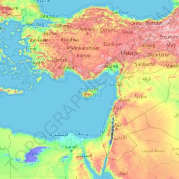
Name: Cyprus topographic map, elevation, terrain.
Location: Cyprus (27.48230 25.64513 42.48230 40.64513)
Average elevation: 483 m
Minimum elevation: -415 m
Maximum elevation: 3,482 m
Other topographic maps
Click on a map to view its topography, its elevation and its terrain.
Agros
Agros (Greek: Αγρός, Turkish: Ağros) is a village built on the Troödos Mountains, in the region of Pitsilia, in southwest Cyprus, which has built amphitheatrically among high mountains at an altitude of 1100 metres with a population of approximately 1,000. The village is located 45 minutes away from the…
Average elevation: 1,109 m
Agros
Agros (Greek: Αγρός, Turkish: Ağros) is a village built on the Troödos Mountains, in the region of Pitsilia, in southwest Cyprus, which has built amphitheatrically among high mountains at an altitude of 1100 metres with a population of approximately 1,000. Agros is one of the most interesting villages…
Average elevation: 1,109 m
Lakatamia park;Lakatamia Park
Cyprus > South Cyprus > Lakatamia > Anthoupolis Refugees Estates
Average elevation: 240 m