
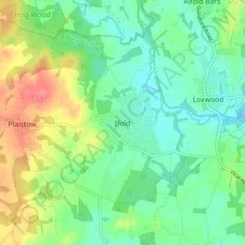
Ifold topographic map
Interactive map
Click on the map to display elevation.
About this map
Name: Ifold topographic map, elevation, terrain.
Average elevation: 41 m
Minimum elevation: 18 m
Maximum elevation: 84 m
West Sussex trails, hiking, mountain biking, running and outdoor activities
Other topographic maps
Click on a map to view its topography, its elevation and its terrain.
Selsey
United Kingdom > England > West Sussex > Chichester
A study published by Princeton University and McGill University, in 2020, concluded that the Manhood Peninsula is at particularly high risk of flooding as its topography is less than 5 metres (16 ft) above the current mean sea level and that by 2100 Selsey will be subject to permanent inundation.
Average elevation: 1 m
West Wittering
United Kingdom > England > West Sussex > Chichester > West Wittering
Average elevation: 2 m
Horncroft Common Plantation
United Kingdom > England > West Sussex > Chichester
Average elevation: 22 m
Wisborough Green
United Kingdom > England > West Sussex > Chichester > Wisborough Green
Average elevation: 29 m
Barlavington
United Kingdom > England > West Sussex > Chichester > Barlavington
Average elevation: 50 m
Westerton
United Kingdom > England > West Sussex > Chichester > Westhampnett > Westerton
Average elevation: 30 m