
Sawai Madhopur topographic map
Interactive map
Click on the map to display elevation.
About this map
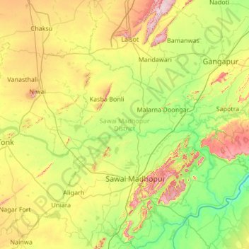
Name: Sawai Madhopur topographic map, elevation, terrain.
Location: Sawai Madhopur, Rajasthan, India (25.74107 75.97983 26.48644 76.85261)
Average elevation: 263 m
Minimum elevation: 166 m
Maximum elevation: 500 m
Other topographic maps
Click on a map to view its topography, its elevation and its terrain.
Udaipur
India > Rajasthan > Girwa Tehsil
Udaipur is located at 24°31′30″N 73°40′38″E / 24.525049°N 73.677116°E / 24.525049; 73.677116. The city covers an area of 64 km2 (25 sq mi) and lies at an altitude of 598.00 m (1,962 ft) above sea level. It is located in the southern region of Rajasthan, near the Gujarat border. The city…
Average elevation: 656 m
Degana
India > Rajasthan > Degana Tehsil
Degana is located at 26°53′42″N 74°19′20″E / 26.895052°N 74.322166°E / 26.895052; 74.322166. It has an average elevation of 353 metres (1161 ft).
Average elevation: 343 m
Kotputli
India > Rajasthan > Kotpuli Tehsil
Kotputli has an average elevation of 439 meters (1,440 ft).
Average elevation: 354 m
Udaipur
India > Rajasthan > Girwa Tehsil
Udaipur is located at 24°31′30″N 73°40′38″E / 24.525049°N 73.677116°E / 24.525049; 73.677116. The city covers an area of 64 km2 (25 sq mi) and lies at an altitude of 598.00 m (1,962 ft) above sea level. It is located in the southern region of Rajasthan, near the Gujarat border. The city…
Average elevation: 656 m
Suratgarh
India > Rajasthan > Suratgarh Tehsil
Suratgarh is located at 29°19′04″N 73°53′56″E / 29.317701°N 73.898935°E / 29.317701; 73.898935. It has an average elevation of 168 metres (551) feet. It is a Northern Part of Thar desert. Seasonal Ghaghar river runs through Northern part of tehsil. Suratgarh has Greenary in Northern part…
Average elevation: 177 m