
Baraga County topographic map
Interactive map
Click on the map to display elevation.
About this map
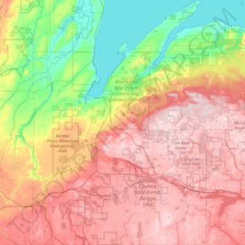
Name: Baraga County topographic map, elevation, terrain.
Location: Baraga County, Michigan, United States (46.41989 -88.67991 46.96711 -87.99111)
Average elevation: 378 m
Minimum elevation: 175 m
Maximum elevation: 598 m
Other topographic maps
Click on a map to view its topography, its elevation and its terrain.
Horseshoe Lake
United States > Michigan > Marquette County > Republic Township
Average elevation: 503 m
Rawsonville
United States > Michigan > Washtenaw County > Ypsilanti Charter Township
Average elevation: 214 m
South Fox Island
United States > Michigan > Leelanau County
North Fox Island has an operational public 3,001-foot-long by 100-foot-wide (914m x 30m) grass airstrip as of August 2023, making it accessible by general aviation. Runway 7 has a displaced threshold of 804 ft. and Runway 25 has a displaced threshold of 999 ft. Both runways have trees at their ends ranging…
Average elevation: 185 m
Grand Mere State Park
United States > Michigan > Berrien County > Stevensville
Average elevation: 185 m
Village of Dansville Community Park
United States > Michigan > Ingham County > Dansville
Average elevation: 289 m
Mooreville
United States > Michigan > Washtenaw County > York Charter Township
Average elevation: 222 m
Dollar Lake
United States > Michigan > Oakland County > Independence Charter Township
Average elevation: 306 m
Charlevoix South Pier Light
United States > Michigan > Charlevoix County > Charlevoix
Average elevation: 180 m
Grand Mere State Park
United States > Michigan > Berrien County > Stevensville
Average elevation: 185 m
Carpenter Lake Nature Preserve
United States > Michigan > Oakland County > Southfield
Average elevation: 207 m
Oxbow
United States > Michigan > Oakland County > White Lake Charter Township
Average elevation: 293 m
Orchard Point
United States > Michigan > Presque Isle County > Presque Isle Township
Average elevation: 198 m