
Larkhill topographic map
Interactive map
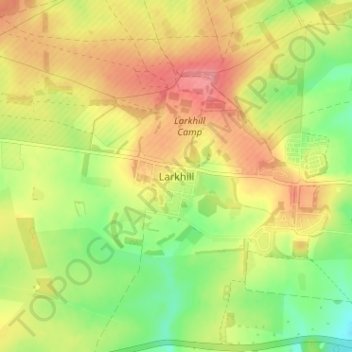
Click on the map to display elevation.
About this map
Name: Larkhill topographic map, elevation, terrain.
Location: Larkhill, Wiltshire, England, SP4 8QB, United Kingdom (51.17648 -1.83763 51.21648 -1.79763)
Average elevation: 111 m
Minimum elevation: 69 m
Maximum elevation: 150 m
Wiltshire trails, hiking, mountain biking, running and outdoor activities
Other topographic maps
Click on a map to view its topography, its elevation and its terrain.
Warminster
United Kingdom > England > Wiltshire
Warminster Town Hall, at the junction of the High Street and Weymouth Street, was designed c. 1837 by Edward Blore at the expense of the 5th Marquess of Bath; the two-storey front elevation is a replica of Longleat, with the addition of a central bellcote, clock and coat of arms. The building was sold by the…
Average elevation: 143 m
Malmesbury
United Kingdom > England > Wiltshire
Malmesbury sits on a flat Cotswolds hilltop at the convergence of two rivers. The town has a maximum elevation of 146 metres (479 ft) and a minimum of 56 metres (184 ft); the average elevation is 92 metres (302 ft) above sea level. From the west, the infant (Bristol) Avon flows from Sherston, and from the…
Average elevation: 84 m
Colerne
United Kingdom > England > Wiltshire
The name Colerne appears in the Domesday Book of 1086. Other early spellings include Culerna, Culerne, Cullerne, Collern. Various interpretations of the name have been proposed. Gover, Mawer and Stenton, in The Place Names of Wiltshire, cite a form aern meaning "house", and suggest that "col-aern might well…
Average elevation: 128 m
Salisbury
United Kingdom > England > Wiltshire
Bishop of Salisbury Hubert Walter was instrumental in the negotiations with Saladin during the Third Crusade, but he spent little time in his diocese prior to his elevation to archbishop of Canterbury. The brothers Herbert and Richard Poore succeeded him and began planning the relocation of the cathedral into…
Average elevation: 72 m
Cranborne Chase & West Wiltshire Downs National Landscape
United Kingdom > England > Wiltshire
Average elevation: 101 m
Salisbury
United Kingdom > England > Wiltshire
Bishop of Salisbury Hubert Walter was instrumental in the negotiations with Saladin during the Third Crusade, but he spent little time in his diocese prior to his elevation to archbishop of Canterbury. The brothers Herbert and Richard Poore succeeded him and began planning the relocation of the cathedral into…
Average elevation: 72 m