Geolocate

Barrow County topographic map

Interactive map

Click on the map to display elevation.

About this map

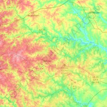
Name: Barrow County topographic map, elevation, terrain.

Location: Barrow County, Georgia, United States (33.89457 -83.86912 34.12752 -83.53747)

Average elevation: 261 m

Minimum elevation: 203 m

Maximum elevation: 336 m

Other topographic maps

Click on a map to view its topography, its elevation and its terrain.

Stone Mountain

United States > Georgia > DeKalb County

The park is owned by the state of Georgia and is currently managed by Herschend Family Entertainment. At its summit, the elevation is 1,686 feet (514 m) above sea level and 825 feet (251 m) above the surrounding area. Stone Mountain is well known for not only its geology, but also the enormous rock relief on…

Average elevation: 299 m

Forge Mill

United States > Georgia > Fannin County

Average elevation: 537 m

Mount Rachel

United States > Georgia > Whitfield County > Dalton

Average elevation: 230 m

Beasley Gap

United States > Georgia > Cherokee County

Average elevation: 390 m

St. Simons

United States > Georgia > Glynn County

Average elevation: 2 m

Silver Hill

United States > Georgia > Chattooga County

Average elevation: 265 m

Whispering Pines

United States > Georgia > Bibb County > Macon

Average elevation: 132 m

Whitesville

United States > Georgia > Harris County

Average elevation: 207 m

Bell Knob

United States > Georgia > Towns County

Average elevation: 725 m

Georgia Island

United States > Georgia > Hall County

Average elevation: 332 m

Waterloo

United States > Georgia > Irwin County

Average elevation: 101 m

Driskolls

United States > Georgia > Carroll County > Villa Rica

Average elevation: 335 m

Sargent

United States > Georgia > Coweta County

Average elevation: 247 m

Dowdell Knob

United States > Georgia > Harris County

Average elevation: 322 m

Bowden

United States > Georgia > Henry County

Average elevation: 253 m

Seabrook

United States > Georgia > Liberty County

Average elevation: 7 m

Newnan Pines

United States > Georgia > Coweta County

Average elevation: 278 m

Dorchester

United States > Georgia > Richmond County > Augusta

Average elevation: 90 m

Moncrief

United States > Georgia > Grady County

Average elevation: 66 m

Salem

United States > Georgia > Richmond County > Augusta

Average elevation: 91 m

Chula

United States > Georgia > Tift County

Average elevation: 110 m

Pleasant Hill

United States > Georgia > Fannin County

Average elevation: 547 m

Mauk

United States > Georgia > Taylor County

Average elevation: 219 m

Rabun Gap

United States > Georgia > Rabun County

Average elevation: 683 m

Elko

United States > Georgia > Houston County

Average elevation: 123 m

McCullough

United States > Georgia > Fannin County

Average elevation: 559 m

Shoal Creek

United States > Georgia > Clarke County > Athens

Average elevation: 225 m

Blowing Spring

United States > Georgia > Walker County

Average elevation: 324 m

Blood Mountain

United States > Georgia > Union County

Blood Mountain is the highest peak on the Georgia section of the Appalachian Trail and the sixth-tallest mountain in Georgia, with an elevation of 4,458 feet (1,359 m). It is located on the border of Lumpkin County with Union County and is within the boundaries of the Chattahoochee National Forest and the…

Average elevation: 1,048 m

Bobo

United States > Georgia > Gordon County

Average elevation: 278 m

Union

United States > Georgia > Henry County

Average elevation: 215 m

Strickland Heights

United States > Georgia > Hall County

Average elevation: 325 m

St. Simons

United States > Georgia > Glynn County

Average elevation: 2 m

Texas

United States > Georgia > Heard County

Average elevation: 258 m

Lake Lure Dam

United States > Georgia > Bacon County > Alma

Average elevation: 59 m

Villanow

United States > Georgia > Walker County

Average elevation: 282 m

Brook Run Park

United States > Georgia > DeKalb County > Dunwoody

Average elevation: 305 m

Mountain Park

United States > Georgia > Gwinnett County

Average elevation: 292 m

Box Springs

United States > Georgia > Talbot County

Average elevation: 124 m

Lake Joy

United States > Georgia > Houston County

Average elevation: 105 m

Saint Simons

United States > Georgia > Glynn County

Average elevation: 2 m

Marble Hill

United States > Georgia > Pickens County

Average elevation: 404 m

Mountville

United States > Georgia > Troup County

Average elevation: 264 m

Shadowlawn

United States > Georgia > Camden County > St. Marys

Average elevation: 3 m

Mableton

United States > Georgia > Cobb County

Average elevation: 298 m

Frontier Trail

United States > Georgia > Hall County

Average elevation: 318 m

Ash

United States > Georgia > Paulding County

Average elevation: 319 m

Westwood

United States > Georgia > Dougherty County > Albany

Average elevation: 68 m

Ellenton

United States > Georgia > Colquitt County

Average elevation: 77 m

Weaver Lake

United States > Georgia > Rockdale County > Conyers

Average elevation: 235 m

Manor

United States > Georgia > Ware County

Average elevation: 47 m

Univeter

United States > Georgia > Cherokee County > Canton

Average elevation: 328 m

Matt

United States > Georgia > Forsyth County

Average elevation: 353 m

Sunnydale Acres

United States > Georgia > Bibb County > Macon

Average elevation: 113 m

Lake Ranch

United States > Georgia > Hall County

Average elevation: 352 m

Ashland

United States > Georgia > Franklin County

Average elevation: 236 m

Dougherty Lake Dam

United States > Georgia > Bibb County > Macon

Average elevation: 142 m

Bonaire

United States > Georgia > Houston County

Average elevation: 100 m

Clyo

United States > Georgia > Effingham County

Average elevation: 24 m

Dorsey

United States > Georgia > Morgan County

Average elevation: 199 m

Lasater Lake

United States > Georgia > Troup County

Average elevation: 250 m

Trion

United States > Georgia > Chattooga County

Average elevation: 218 m

Bald Mountain

United States > Georgia > Murray County

Average elevation: 986 m

Epworth

United States > Georgia > Fannin County

Average elevation: 524 m

Mineral Bluff

United States > Georgia > Fannin County

Average elevation: 516 m

Toccoa Falls

United States > Georgia > Stephens County > Toccoa

Average elevation: 335 m

Henrico

United States > Georgia > DeKalb County

Average elevation: 269 m

Lanier Island

United States > Georgia > Glynn County

Average elevation: 3 m

Terrace Manor

United States > Georgia > Richmond County > Augusta

Average elevation: 100 m

Bay

United States > Georgia > Colquitt County

Average elevation: 94 m

Monks Crossing

United States > Georgia > Lowndes County

Average elevation: 57 m

Louise Lake

United States > Georgia > Spalding County

Average elevation: 269 m

Corbin

United States > Georgia > Bartow County

Average elevation: 308 m

Cisco

United States > Georgia > Murray County

Average elevation: 293 m

Shandra Estates

United States > Georgia > Fulton County

Average elevation: 289 m

Wilscot

United States > Georgia > Fannin County

Average elevation: 614 m

Norman Park

United States > Georgia > Colquitt County

Average elevation: 100 m

Suches

United States > Georgia > Union County

Average elevation: 871 m

Yellow Dirt

United States > Georgia > Heard County

Average elevation: 237 m

Dial

United States > Georgia > Fannin County

Average elevation: 612 m

Kentucky Island

United States > Georgia > Wayne County

Average elevation: 19 m

Piedmont Park

United States > Georgia > Fulton County > Atlanta

Average elevation: 283 m

Aboretum

United States > Georgia > Cobb County

Average elevation: 319 m