Geolocate

Abruzzo topographic map

Interactive map

Click on the map to display elevation.

Abruzzo

In Abruzzo there are two climatic zones. The coastal strip and sub-Apennine hills have a climate markedly different from that of the mountainous interior. Coastal areas have a Mediterranean climate with hot dry summers and mild winters. Inland hilly areas have a sublittoral climate with temperatures decreasing progressively with increasing altitude. Precipitation is also strongly affected by the presence of the Apennines mountain range. Rainfall is abundant on slopes oriented to the west, and lower in east and east-facing slopes. The Adriatic coast is shielded from rainfall by the barrier effect created by the Apennines. The minimum annual rainfall is found in some inland valleys, sheltered by mountain ranges, such as Peligna or Tirino (Ofena, Capestrano), where as little as 500 millimetres (19.7 inches) were recorded. Rainfall along the coast almost always never falls below 600 millimetres (23.6 inches). Teramo has relatively less rainfall (about 800 millimetres (31.5 inches)) than Chieti, while Ortona, Vasto, and Costa dei Trabocchi have comparatively less rainfall. The highest rainfall occurs in upland areas on the border with Lazio; they are especially vulnerable to Atlantic disturbances. Around 1,500 to 2,000 millimetres (59 to 79 inches) of precipitation is typical.

Wikipedia (CC-BY-SA 3.0)

About this map

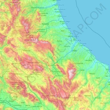
Name: Abruzzo topographic map, elevation, terrain.

Location: Abruzzo, Italy (41.68204 13.01897 42.89508 14.78389)

Average elevation: 658 m

Minimum elevation: -1 m

Maximum elevation: 2,775 m

Other topographic maps

Click on a map to view its topography, its elevation and its terrain.

Matterhorn

Italy > Aosta Valley > Valtournenche

In 1999, the summit height was precisely determined to be at 4,477.54 m (14,690 ft) above sea level by using Global Positioning System technology as part of the TOWER Project (Top of the World Elevations Remeasurement) and to an accuracy of less than one centimetre, which allows future changes to be tracked.

Average elevation: 3,295 m

Vico Pancellorum

Italy > Tuscany > Lucca

Average elevation: 644 m

Corbane

Italy > Veneto > Verona > Bosco Chiesanuova

Average elevation: 1,089 m

Treppignana

Italy > Tuscany > Lucca > Fosciandora

Average elevation: 477 m

Tremezzo

Italy > Lombardy > Como > Tremezzina

Average elevation: 378 m

Castello dei Pecorari

Italy > Pesaro e Urbino > Piobbico > Fratta

Average elevation: 508 m

Vich

Italy > Veneto > Belluno > Voltago Agordino

Average elevation: 1,328 m

Verni

Italy > Tuscany > Lucca > Gallicano

Average elevation: 515 m

Monzone

Italy > Emilia-Romagna > Reggio nell'Emilia

Average elevation: 678 m

Maranta

Italy > Lombardy > Sondrio > Stazzona

Average elevation: 895 m

Destra Volturno

Italy > Campania > Caserta > Castel Volturno

Average elevation: 1 m

Casciana

Italy > Tuscany > Lucca

Average elevation: 651 m

Vergemoli

Italy > Tuscany > Lucca

Average elevation: 666 m

Equi Terme

Italy > Tuscany

Average elevation: 503 m

Terrusso

Italy > Liguria > Genoa > Bargagli

Average elevation: 546 m

Mount Vesuvius

Italy > Campania > Naples > Trecase

The volcano's slopes are scarred by lava flows, while the rest are heavily vegetated, with scrub and forests at higher altitudes and vineyards lower down.

Average elevation: 862 m

Isola Santa

Italy > Tuscany > Lucca > Careggine

Average elevation: 936 m

Cantiere-Ponticello

Italy > Tuscany > Ponticello

Average elevation: 234 m

Colle delle Finestre

Italy > Piedmont > Torino > Meana di Susa

Average elevation: 2,181 m

Tenaglie

Italy > Umbria > Terni > Montecchio

Average elevation: 308 m

Monte Faito

Italy > Campania > Naples > Vico Equense

The summit has an elevation of 1,131 metres (3,711 ft).

Average elevation: 831 m

Tormeno

Italy > Veneto > Vicenza

Average elevation: 54 m

Campegli

Italy > Liguria > Genoa > Castiglione Chiavarese

Average elevation: 302 m

Ossuccio

Italy > Lombardy > Como > Tremezzina

Average elevation: 461 m

Castiglioncello del Trinoro

Italy > Tuscany > Siena > Sarteano

Average elevation: 614 m

Coloretta

Italy > Tuscany

Average elevation: 817 m

Matterhorn

Italy > Aosta Valley > Valtournenche

In 1999, the summit height was precisely determined to be at 4,477.54 m (14,690 ft) above sea level by using Global Positioning System technology as part of the TOWER Project (Top of the World Elevations Remeasurement) and to an accuracy of less than one centimetre, which allows future changes to be tracked.

Average elevation: 3,295 m

Bavastrelli

Italy > Liguria > Genoa > Propata

Average elevation: 1,089 m

Cereseto

Italy > Emilia-Romagna > Parma > Compiano

Average elevation: 821 m

Sn2

Italy > Piedmont > Vercelli > Boccioleto

Average elevation: 1,290 m

Campo di Fano

Italy > Abruzzo > L'Aquila > Prezza

Average elevation: 418 m

Sostino

Italy > Umbria > Perugia > Foligno

Average elevation: 706 m

San Chiaffredo

Italy > Piedmont > Cuneo > Barge

Average elevation: 552 m

Bindella

Italy > Lombardy > Como > Erba

Average elevation: 311 m

Tarsogno

Italy > Emilia-Romagna > Parma > Tornolo

Average elevation: 888 m

Botasi

Italy > Liguria > Genoa

Average elevation: 651 m

Monte Zatta di Levante

Italy > Liguria > Genoa

Average elevation: 1,087 m

Molino della Pergola

Italy > Emilia-Romagna > Bologna > Campeggio

Average elevation: 620 m

Palazzo Valgorrera

Italy > Piedmont > Torino > Poirino

Average elevation: 252 m

Scortica

Italy > Liguria > La Spezia > San Cipriano

Average elevation: 205 m

Siberia

Italy > Piedmont > Torino

Average elevation: 186 m

Montanara

Italy > Lombardy > Mantua > Curtatone

Average elevation: 24 m

Mount Etna

Italy > Sicily > Catania

During the first 1500 years AD, many eruptions went unrecorded (or records have been lost); among the more significant are: (1) an eruption in about 1030 AD near Monte Ilice on the lower southeast flank, which produced a lava flow that travelled about 10 km, reaching the sea north of Acireale; the villages of…

Average elevation: 1,157 m

Matterhorn

Italy > Aosta Valley > Valtournenche

In 1999, the summit height was precisely determined to be at 4,477.54 m (14,690 ft) above sea level by using Global Positioning System technology as part of the TOWER Project (Top of the World Elevations Remeasurement) and to an accuracy of less than one centimetre, which allows future changes to be tracked.

Average elevation: 3,295 m

Borgata Rodetti

Italy > Piedmont > Torino > Meana di Susa

Average elevation: 660 m

Ponticelli

Italy > Umbria > Perugia

Ponticelli is a frazione of the comune of Città della Pieve in the Province of Perugia, Umbria, central Italy. It stands at an elevation of 249 metres above sea level. At the time of the Istat census of 2001 it had 610 inhabitants.

Average elevation: 275 m

Ortler - Ortles

Italy > Trentino – Alto Adige/Südtirol > South Tyrol > Stilfs - Stelvio

The Ortler was first climbed by Josef Pichler [de] ("Pseirer-Josele"), a chamois hunter from St. Leonhard in Passeier, and his companions Johann Leitner and Johann Klausner from Zell am Ziller on 27 September 1804. The ascent had been a request of Archduke Johann of Austria, who felt strongly that after the…

Average elevation: 3,175 m

Mount Vesuvius

Italy > Campania > Naples > Trecase

The volcano's slopes are scarred by lava flows, while the rest are heavily vegetated, with scrub and forests at higher altitudes and vineyards lower down.

Average elevation: 862 m

Palatine Hill

Italy > Lazio > Roma Capitale > Rome

In 2007 the legendary Lupercal cave was claimed to have been found beneath the remains of the Domus Livia (House of Livia) on the Palatine. Archaeologists came across the 16-metre-deep cavity while restoring the decaying palace, with a richly decorated vault encrusted with mosaics and seashells. The Lupercal…

Average elevation: 40 m

Pidone

Italy > Piedmont > Torino > Bobbio Pellice

Average elevation: 1,125 m

Matterhorn

Italy > Aosta Valley > Valtournenche

In 1999, the summit height was precisely determined to be at 4,477.54 m (14,690 ft) above sea level by using Global Positioning System technology as part of the TOWER Project (Top of the World Elevations Remeasurement) and to an accuracy of less than one centimetre, which allows future changes to be tracked.

Average elevation: 3,295 m

Barberi

Italy > Pescara > Collecorvino

Average elevation: 126 m

Belvedere

Italy > Veneto > Vicenza

Average elevation: 68 m

Monte Torrone

Italy > Umbria > Perugia > Campello sul Clitunno

Average elevation: 1,055 m

Monte Zuccone

Italy > Tuscany > Carrara

Average elevation: 600 m

Montefioralle

Italy > Tuscany > Florence > Greve in Chianti

Average elevation: 346 m

Gardola

Italy > Lombardy > Brescia > Tignale

Average elevation: 476 m

Lonca

Italy > Friuli – Venezia Giulia > Udine > Codroipo

Average elevation: 33 m

Bolgheri

Italy > Tuscany > Livorno > Castagneto Carducci

Average elevation: 110 m

Le Crest

Italy > Aosta Valley > Ayas > Champoluc

Average elevation: 2,052 m

Ca' dei Marchi

Italy > Emilia-Romagna > Bologna > Valsamoggia > Savigno

Average elevation: 551 m

Truc di Miola

Italy > Piedmont > Torino > La Cassa

Average elevation: 467 m

Monte Zuccone

Italy > Emilia-Romagna > Parma > Tornolo

Average elevation: 1,106 m

Peron

Italy > Veneto > Belluno > Sedico

Average elevation: 579 m

Borago

Italy > Veneto > Verona > Assenza

Average elevation: 362 m

Rivazzo

Italy > Tuscany > Castevoli

Average elevation: 359 m

Tempa Parese

Italy > Basilicata > Matera > Stigliano

Average elevation: 425 m

San Giuseppe di Cairo

Italy > Liguria > Savona > Cairo Montenotte

Average elevation: 394 m

Frisolino

Italy > Liguria > Genoa

Average elevation: 329 m

Monasterace Marina

Italy > Calabria > Reggio Calabria

Average elevation: 19 m

Ceserano

Italy > Tuscany

Average elevation: 198 m

Cerasolo Ausa

Italy > Emilia-Romagna > Rimini > Cerasolo

Average elevation: 76 m

Mount Vesuvius

Italy > Campania > Naples > Trecase

The volcano's slopes are scarred by lava flows, while the rest are heavily vegetated, with scrub and forests at higher altitudes and vineyards lower down.

Average elevation: 862 m

Marina Romea

Italy > Emilia-Romagna > Ravenna > Ravenna

Average elevation: 0 m

Vetulonia

Italy > Tuscany > Grosseto

Average elevation: 106 m

Capo Marrargiu

Italy > Sardinia > Aristanis/Oristano > Bosa

Average elevation: 34 m

Portu Suedda

Italy > Sardinia > Aristanis/Oristano > Cabras

Average elevation: 6 m

Riofreddo

Italy > Liguria > Savona

Average elevation: 816 m

Monte Ciappa

Italy > Liguria > La Spezia > Carro

Average elevation: 339 m

Margheria

Italy > Piedmont > Torino > Mathi

Average elevation: 422 m

Passo di Riva

Italy > Veneto > Vicenza > Dueville

Average elevation: 61 m

Nivione

Italy > Lombardy > Pavia

Average elevation: 553 m

Fiorano

Italy > Emilia-Romagna > Piacenza > Travo

Average elevation: 284 m

Villa d'Este

Italy > Lazio > Roma Capitale > Tivoli

Tivoli had been a popular summer residence since ancient Roman times due to its altitude, cooler temperatures and its proximity to the Villa Hadriana, the summer residence of the Emperor Hadrian I. The position of Governor of Tivoli came with an official residence located in a former convent of the Benedictine…

Average elevation: 203 m

Casale

Italy > Piedmont > Torino > Cossano Canavese

Average elevation: 317 m

Case Galinverno

Italy > Piedmont > Torino > Vallo Torinese

Average elevation: 622 m

Catanzaro Lido

Italy > Calabria > Catanzaro > Catanzaro

Average elevation: 31 m

Pozzaglio

Italy > Lombardy > Cremona > Pozzaglio ed Uniti

Average elevation: 50 m

Capoli

Italy > Tuscany > Lucca

Average elevation: 761 m

Isola Bisentina

Italy > Lazio > Viterbo > Capodimonte

Average elevation: 304 m

Nubia

Italy > Sicily > Trapani > Paceco

Average elevation: 4 m