
Make a donation
Gear up for your next adventure:
As an Amazon Associate, this site earns from qualifying purchases at no extra cost to you.
Beverly Hills topographic map
Click on the map to display elevation.
Make a donation
Gear up for your next adventure:
As an Amazon Associate, this site earns from qualifying purchases at no extra cost to you.
About this map
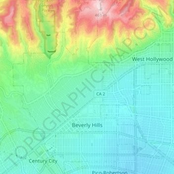
Name: Beverly Hills topographic map, elevation, terrain.
Average elevation: 143 m
Minimum elevation: 38 m
Maximum elevation: 444 m
Make a donation
Gear up for your next adventure:
As an Amazon Associate, this site earns from qualifying purchases at no extra cost to you.
Other topographic maps
Click on a map to view its topography, its elevation and its terrain.
Miraleste
United States > California > Los Angeles County > Rancho Palos Verdes
Average elevation: 201 m
San Fernando Valley
United States > California > Los Angeles County > Los Angeles
Average elevation: 496 m
Make a donation
Gear up for your next adventure:
As an Amazon Associate, this site earns from qualifying purchases at no extra cost to you.
Make a donation
Gear up for your next adventure:
As an Amazon Associate, this site earns from qualifying purchases at no extra cost to you.
Santa Monica Mountains
United States > California > Los Angeles County
On January 17, 2007, an unusually cold storm brought snow in the Santa Monica Mountains. The hills above Malibu picked up three inches (eight centimeters) of snow - the first measurable snow in fifty years. Snow was reported on Boney Peak in the winter of 2005; and in March 2006, snow also fell on the summit…
Average elevation: 201 m
Make a donation
Gear up for your next adventure:
As an Amazon Associate, this site earns from qualifying purchases at no extra cost to you.
Mount San Antonio
United States > California > Los Angeles County
The prehistoric Hog Back landslide lies in the canyon of San Antonio Creek at 4000' elevation. When the slide occurred, it dammed the river, whose depth built up until the water was released catastrophically, forming a slot canyon which now holds some of the area's few good rock climbing routes (difficulty…
Average elevation: 2,675 m
Hungry Valley SVRA
United States > California > Los Angeles County > Gorman
Average elevation: 1,303 m
Make a donation
Gear up for your next adventure:
As an Amazon Associate, this site earns from qualifying purchases at no extra cost to you.
Universal City Overlook
United States > California > Los Angeles County > Los Angeles
Average elevation: 278 m
Green Valley
United States > California > Los Angeles County
Green Valley is an unincorporated community and census-designated place (CDP) in the Sierra Pelona Mountains, in Los Angeles County, California. It lies at an elevation of 2936 feet (895 m). The population was 1,036 at the 2020 census, up from 1,027 at the 2010 census.
Average elevation: 1,057 m
Santa Monica Mountains
United States > California > Los Angeles County > Unincorporated Santa Monica Mountains
On January 17, 2007, an unusually cold storm brought snow in the Santa Monica Mountains. The hills above Malibu picked up three inches (eight centimeters) of snow - the first measurable snow in fifty years. Snow was reported on Boney Peak in the winter of 2005; and in March 2006, snow also fell on the summit…
Average elevation: 304 m
Make a donation
Gear up for your next adventure:
As an Amazon Associate, this site earns from qualifying purchases at no extra cost to you.
Mount Baden-Powell
United States > California > Los Angeles County
At 9,407 feet (2,867 m) in elevation, Mount Baden-Powell is traditionally considered to be the 5th highest peak of the San Gabriel Range; however it is the second highest peak in the range with more than 1,000 feet (300 m) of prominence, and is the highest peak not part of the Mount San Antonio massif.
Average elevation: 2,429 m
Make a donation
Gear up for your next adventure:
As an Amazon Associate, this site earns from qualifying purchases at no extra cost to you.
West Puente Valley
United States > California > Los Angeles County > West Puente Valley
Average elevation: 101 m
Make a donation
Gear up for your next adventure:
As an Amazon Associate, this site earns from qualifying purchases at no extra cost to you.
Make a donation
Gear up for your next adventure:
As an Amazon Associate, this site earns from qualifying purchases at no extra cost to you.
Point Dume
United States > California > Los Angeles County > Malibu
Offshore, the nutrient-rich and frigid waters of the Pacific enhance the entire marine food web, from primary producers such as algae and zooplankton to apex predators like sand sharks, bottlenose dolphins, and gray whales. Within the Marine Protected Areas (MPAs), the diverse seafloor topography encompasses…
Average elevation: 12 m
Make a donation
Gear up for your next adventure:
As an Amazon Associate, this site earns from qualifying purchases at no extra cost to you.
Portuguese Bend
United States > California > Los Angeles County > Rancho Palos Verdes
Average elevation: 66 m
Oak Hill
United States > California > Los Angeles County > Unincorporated Santa Monica Mountains
Average elevation: 478 m
Make a donation
Gear up for your next adventure:
As an Amazon Associate, this site earns from qualifying purchases at no extra cost to you.
Make a donation
Gear up for your next adventure:
As an Amazon Associate, this site earns from qualifying purchases at no extra cost to you.
Oak Spring Canyon Park
United States > California > Los Angeles County > Santa Clarita
Average elevation: 519 m
Make a donation
Gear up for your next adventure:
As an Amazon Associate, this site earns from qualifying purchases at no extra cost to you.
Make a donation
Gear up for your next adventure:
As an Amazon Associate, this site earns from qualifying purchases at no extra cost to you.
Make a donation
Gear up for your next adventure:
As an Amazon Associate, this site earns from qualifying purchases at no extra cost to you.
Point Dume
United States > California > Los Angeles County > Malibu
Offshore, the nutrient-rich and frigid waters of the Pacific enhance the entire marine food web, from primary producers such as algae and zooplankton to apex predators like sand sharks, bottlenose dolphins, and gray whales. Within the Marine Protected Areas (MPAs), the diverse seafloor topography encompasses…
Average elevation: 12 m
San Fernando Valley
United States > California > Los Angeles County > Los Angeles
Average elevation: 496 m
Make a donation
Gear up for your next adventure:
As an Amazon Associate, this site earns from qualifying purchases at no extra cost to you.
Miraleste
United States > California > Los Angeles County > Rancho Palos Verdes
Average elevation: 201 m
Lake Elizabeth
United States > California > Los Angeles County
The lake, at 3,228 ft (984 m) in elevation, is within the Angeles National Forest. It is a natural perennial lake, but may dry up entirely during drought years. It is south of the western Antelope Valley.
Average elevation: 1,065 m
South Los Angeles
United States > California > Los Angeles County > Los Angeles
Average elevation: 421 m
Make a donation
Gear up for your next adventure:
As an Amazon Associate, this site earns from qualifying purchases at no extra cost to you.
Twin Lakes
United States > California > Los Angeles County > Unincorporated Chatsworth
Average elevation: 400 m
Will Rogers State Historic Park
United States > California > Los Angeles County > Los Angeles
Average elevation: 152 m
Make a donation
Gear up for your next adventure:
As an Amazon Associate, this site earns from qualifying purchases at no extra cost to you.
Santa Susana Mountains
United States > California > Los Angeles County > Unincorporated Chatsworth
Average elevation: 546 m
Make a donation
Gear up for your next adventure:
As an Amazon Associate, this site earns from qualifying purchases at no extra cost to you.
Mount Baden-Powell
United States > California > Los Angeles County
At 9,407 feet (2,867 m) in elevation, Mount Baden-Powell is traditionally considered to be the 5th highest peak of the San Gabriel Range; however it is the second highest peak in the range with more than 1,000 feet (300 m) of prominence, and is the highest peak not part of the Mount San Antonio massif.
Average elevation: 2,429 m
Altacanyada
United States > California > Los Angeles County > La Cañada Flintridge
Average elevation: 584 m
Mount San Antonio
United States > California > Los Angeles County
The prehistoric Hog Back landslide lies in the canyon of San Antonio Creek at 4000' elevation. When the slide occurred, it dammed the river, whose depth built up until the water was released catastrophically, forming a slot canyon which now holds some of the area's few good rock climbing routes (difficulty…
Average elevation: 2,675 m
Make a donation
Gear up for your next adventure:
As an Amazon Associate, this site earns from qualifying purchases at no extra cost to you.
El Escorpion Park
United States > California > Los Angeles County > Los Angeles
Average elevation: 341 m
Eaton Canyon Waterfall
United States > California > Los Angeles County > Pasadena
Average elevation: 639 m
Make a donation
Gear up for your next adventure:
As an Amazon Associate, this site earns from qualifying purchases at no extra cost to you.
Horsethief Canyon Park
United States > California > Los Angeles County > San Dimas
Average elevation: 373 m
Calabasas Highlands
United States > California > Los Angeles County > Calabasas
Average elevation: 404 m
Make a donation
Gear up for your next adventure:
As an Amazon Associate, this site earns from qualifying purchases at no extra cost to you.
Foxfield Park
United States > California > Los Angeles County > Westlake Village
Average elevation: 301 m
San Fernando Valley
United States > California > Los Angeles County > Los Angeles
Average elevation: 496 m
Make a donation
Gear up for your next adventure:
As an Amazon Associate, this site earns from qualifying purchases at no extra cost to you.
Twin Lakes
United States > California > Los Angeles County > Unincorporated Chatsworth
Average elevation: 400 m
Make a donation
Gear up for your next adventure:
As an Amazon Associate, this site earns from qualifying purchases at no extra cost to you.
Veterans Administration
United States > California > Los Angeles County > Veterans Administration
Average elevation: 105 m
Calabasas Highlands
United States > California > Los Angeles County > Calabasas
Average elevation: 404 m
Make a donation
Gear up for your next adventure:
As an Amazon Associate, this site earns from qualifying purchases at no extra cost to you.
Monte Nido
United States > California > Los Angeles County > Unincorporated Santa Monica Mountains
Average elevation: 327 m
Make a donation
Gear up for your next adventure:
As an Amazon Associate, this site earns from qualifying purchases at no extra cost to you.