
Kolkata topographic map
Click on the map to display elevation.
Kolkata
Spread roughly north–south along the east bank of the Hooghly River, Kolkata sits within the lower Ganges Delta of eastern India approximately 75 km (47 mi) west of the international border with Bangladesh; the city's elevation is 1.5–9 m (5–30 ft). Much of the city was originally a wetland that was reclaimed over the decades to accommodate a burgeoning population. The remaining undeveloped areas, known as the East Kolkata Wetlands, were designated a "wetland of international importance" by the Ramsar Convention (1975). As with most of the Indo-Gangetic Plain, the soil and water are predominantly alluvial in origin. Kolkata is located over the "Bengal basin", a pericratonic tertiary basin. Bengal basin comprises three structural units: shelf or platform in the west; central hinge or shelf/slope break; and deep basinal part in the east and southeast. Kolkata is located atop the western part of the hinge zone which is about 25 km (16 mi) wide at a depth of about 45,000 m (148,000 ft) below the surface. The shelf and hinge zones have many faults, among them some are active. Total thickness of sediment below Kolkata is nearly 7,500 m (24,600 ft) above the crystalline basement; of these the top 350–450 m (1,150–1,480 ft) is Quaternary, followed by 4,500–5,500 m (14,760–18,040 ft) of Tertiary sediments, 500–700 m (1,640–2,300 ft) trap wash of Cretaceous trap and 600–800 m (1,970–2,620 ft) Permian-Carboniferous Gondwana rocks. The quaternary sediments consist of clay, silt, and several grades of sand and gravel. These sediments are sandwiched between two clay beds: the lower one at a depth of 250–650 m (820–2,130 ft); the upper one 10–40 m (30–130 ft) in thickness. According to the Bureau of Indian Standards, on a scale ranging from I to V in order of increasing susceptibility to earthquakes, the city lies inside seismic zone III.
About this map
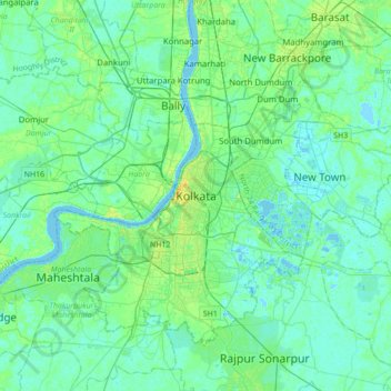
Name: Kolkata topographic map, elevation, terrain.
Location: Kolkata, Kolkata District, West Bengal, 700073, India (22.41265 88.20390 22.73265 88.52390)
Average elevation: 5 m
Minimum elevation: -2 m
Maximum elevation: 21 m
Other topographic maps
Click on a map to view its topography, its elevation and its terrain.
Purba Medinipur District
Purba Medinipur district is part of the lower Indo-Gangetic Plain and Eastern coastal plains. Topographically, the district can be divided into two parts – (a) almost entirely flat plains on the west, east and north, (b) the coastal plains on the south. The vast expanse of land is formed of alluvium and is…
Average elevation: 6 m
Baruipur
The Baruipur CD block is located at 22°21′56″N 88°25′57″E / 22.3654432°N 88.4325028°E / 22.3654432; 88.4325028. It has an average elevation of 9 metres (30 ft).
Average elevation: 4 m
Uttar Dinajpur District
The regional topography is generally flat with a gentle southerly slope towards which the main rivers like Kulik, Nagar, Mahananda. The District forms a part of the basin lying between Rajmahal hills on the east. The older alluvium is estimated to be Pleistocene age. Uttar Dinajpur is bestowed with a very…
Average elevation: 45 m
Namkhana
Namkhana CD block is located at 21°46′12″N 88°13′53″E / 21.7699°N 88.2315°E / 21.7699; 88.2315. It has an average elevation of 4 metres (13 ft).
Average elevation: 2 m
Thakurpukur Maheshtala
Thakurpukur Maheshtala CD block is located at 22°30′31″N 88°15′12″E / 22.5086210°N 88.2532182°E / 22.5086210; 88.2532182. It has an average elevation of 9 metres (30 ft).
Average elevation: 5 m
Kolkata
India > West Bengal > Kolkata
Spread roughly north–south along the east bank of the Hooghly River, Kolkata sits within the lower Ganges Delta of eastern India approximately 75 km (47 mi) west of the international border with Bangladesh; the city's elevation is 1.5–9 m (5–30 ft). Much of the city was originally a wetland that was…
Average elevation: 5 m
Purba Bardhaman
Different types of soil are encountered in topographical biological, hydrological, and geological conditions in the Burdwan district. In the west, coarse gritty soil blended with rock fragments is formed from the weathering of pegmatite, quartz veins and conglomeratic sandstones, where as sandy soil…
Average elevation: 30 m
Rajpur Sonarpur
India > West Bengal > Sonarpur
Rajpur Sonarpur is located at 22°26′18″N 88°25′55″E / 22.4382026°N 88.4320450°E / 22.4382026; 88.4320450. It has an average elevation of 9 metres (30 ft).
Average elevation: 4 m
Magrahat - I
Magrahat I CD block is located at 22°14′31″N 88°22′42″E / 22.2420°N 88.3784°E / 22.2420; 88.3784. It has an average elevation of 8 metres (26 ft).
Average elevation: 4 m
Darjeeling district
The Darjeeling hill area is formed of comparatively recent rock structure that has a direct bearing on landslides. Heavy monsoon precipitation contributes to the landslides. Soils of Darjeeling hill areas are extremely varied, depending on elevation, degree of slope, vegetative cover and geolithology.
Average elevation: 728 m
Kultali
The Kultali CD block is located at 22°05′12″N 88°35′37″E / 22.0866°N 88.5937°E / 22.0866; 88.5937. It has an average elevation of 7 metres (23 ft).
Average elevation: 3 m
Kulpi
Kulpi CD block is located at 22°04′53″N 88°14′42″E / 22.0815°N 88.2449°E / 22.0815; 88.2449. It has an average elevation of 6 metres (20 ft).
Average elevation: 3 m
Bhangar - I
The Bhangar I CD block is located at 22°30′45″N 88°36′35″E / 22.5126°N 88.6097°E / 22.5126; 88.6097. It has an average elevation of 9 metres (30 ft).
Average elevation: 3 m
Basanti
Basanti CD block is located at 22°11′54″N 88°42′50″E / 22.1983°N 88.7139°E / 22.1983; 88.7139. It has an average elevation of 6 metres (20 ft).
Average elevation: 3 m
Sagar
Sagar CD block is located at 21°39′10″N 88°04′31″E / 21.6528°N 88.0753°E / 21.6528; 88.0753. It has an average elevation of 4 metres (13 ft).
Average elevation: 2 m
Jaynagar - I
The Jaynagar I CD block is located at 22°10′31″N 88°25′12″E / 22.1751965°N 88.4200762°E / 22.1751965; 88.4200762. It has an average elevation of 8 metres (26 ft).
Average elevation: 4 m
Canning - II
Canning II CD block is located at 22°18′50″N 88°39′54″E / 22.3139917°N 88.6650753°E / 22.3139917; 88.6650753. It has an average elevation of 6 metres (20 ft).
Average elevation: 3 m
Maheshtala
India > West Bengal > Thakurpukur Maheshtala
Maheshtala is located at 22°30′31″N 88°15′12″E / 22.5086210°N 88.2532182°E / 22.5086210; 88.2532182. It has an average elevation of 9 metres (30 ft).
Average elevation: 5 m
Mathurapur - II
Mathurapur II CD block is located at 22°07′13″N 88°23′39″E / 22.1203°N 88.3943°E / 22.1203; 88.3943. It has an average elevation of 7 metres (23 ft).
Average elevation: 3 m
Falta
The Falta CD block is located at 22°18′07″N 88°07′42″E / 22.3020°N 88.1284°E / 22.3020; 88.1284. It has an average elevation of 8 metres (26 ft).
Average elevation: 4 m
Jaynagar - II
The Jaynagar II CD block is located at 22°10′31″N 88°25′12″E / 22.1751965°N 88.4200762°E / 22.1751965; 88.4200762. It has an average elevation of 8 metres (26 ft).
Average elevation: 4 m
Mandirbazar
Mandirbazar CD block is located at 22°09′48″N 88°19′33″E / 22.1633°N 88.3258°E / 22.1633; 88.3258. It has an average elevation of 7 metres (23 ft).
Average elevation: 4 m
Cooch Behar
Cooch Behar is a flat region with a slight southeastern slope along which the main rivers of the district flow. Most of the highland areas are in the Sitalkuchi region, and most of the low-lying lands lie in Dinhata region. The elevation of the town is 48 meters above mean sea level. The Torsa river flows by…
Average elevation: 41 m
Kamarhati Municipality children's park
India > West Bengal > Barrackpur - II > Kolkata
Average elevation: 5 m
Baruipur
India > West Bengal > Baruipur
Baruipur is located at 22°21′56″N 88°25′57″E / 22.3654432°N 88.4325028°E / 22.3654432; 88.4325028. It has an average elevation of 9 metres (30 ft).
Average elevation: 5 m