
Make a donation
Gear up for your next adventure:
As an Amazon Associate, this site earns from qualifying purchases at no extra cost to you.
Sekhukhune District Municipality topographic map
Click on the map to display elevation.
Make a donation
Gear up for your next adventure:
As an Amazon Associate, this site earns from qualifying purchases at no extra cost to you.
About this map
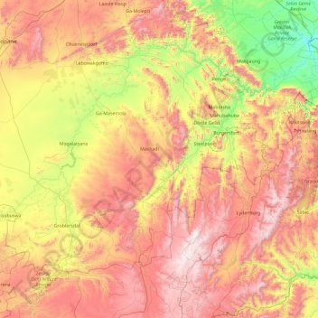
Name: Sekhukhune District Municipality topographic map, elevation, terrain.
Location: Sekhukhune District Municipality, Limpopo, South Africa (-25.42284 28.89162 -24.20403 30.75898)
Average elevation: 1,199 m
Minimum elevation: 378 m
Maximum elevation: 2,306 m
Make a donation
Gear up for your next adventure:
As an Amazon Associate, this site earns from qualifying purchases at no extra cost to you.
Other topographic maps
Click on a map to view its topography, its elevation and its terrain.
The Oaks
South Africa > Limpopo > Mopani District Municipality > Maruleng Local Municipality
Average elevation: 483 m
Giyani
South Africa > Limpopo > Mopani District Municipality > Greater Giyani Local Municipality
Average elevation: 481 m
Leeupoort Vakansiedorp
South Africa > Limpopo > Waterberg District Municipality > Thabazimbi Local Municipality
Average elevation: 1,087 m
Make a donation
Gear up for your next adventure:
As an Amazon Associate, this site earns from qualifying purchases at no extra cost to you.
Pienaarsrivier
South Africa > Limpopo > Waterberg District Municipality > Bela Bela Local Municipality
Average elevation: 1,042 m
Tzaneen Dam
South Africa > Limpopo > Mopani District Municipality > Greater Tzaneen Local Municipality
Average elevation: 721 m
Hoedspruit
South Africa > Limpopo > Mopani District Municipality > Maruleng Local Municipality
Average elevation: 524 m
Make a donation
Gear up for your next adventure:
As an Amazon Associate, this site earns from qualifying purchases at no extra cost to you.
Tzaneen
South Africa > Limpopo > Mopani District Municipality > Greater Tzaneen Local Municipality
Average elevation: 737 m
Selati River
South Africa > Limpopo > Mopani District Municipality > Ba-Phalaborwa Local Municipality
Average elevation: 408 m
Thabazimbi
South Africa > Limpopo > Waterberg District Municipality > Thabazimbi Local Municipality
Average elevation: 1,077 m
Tzaneen Dam
South Africa > Limpopo > Mopani District Municipality > Greater Tzaneen Local Municipality
Average elevation: 721 m
Make a donation
Gear up for your next adventure:
As an Amazon Associate, this site earns from qualifying purchases at no extra cost to you.
Dan
South Africa > Limpopo > Mopani District Municipality > Greater Tzaneen Local Municipality
Average elevation: 573 m
Jimmy Jones, South Africa
South Africa > Limpopo > Vhembe District Municipality > Thulamela Local Municipality
Average elevation: 548 m
Mahubahuba
South Africa > Limpopo > Sekhukhune District Municipality > Greater Tubatse Local Municipality
Average elevation: 752 m
Doorndraai Dam
South Africa > Limpopo > Waterberg District Municipality > Mookgopong Local Municipality
Average elevation: 1,258 m
Make a donation
Gear up for your next adventure:
As an Amazon Associate, this site earns from qualifying purchases at no extra cost to you.
Steelpoort
South Africa > Limpopo > Sekhukhune District Municipality > Greater Tubatse Local Municipality
Average elevation: 854 m
Ga-Monene
South Africa > Limpopo > Waterberg District Municipality > Mogalakwena Local Municipality
Average elevation: 934 m
Letsitele
South Africa > Limpopo > Mopani District Municipality > Greater Tzaneen Local Municipality
Average elevation: 562 m
Make a donation
Gear up for your next adventure:
As an Amazon Associate, this site earns from qualifying purchases at no extra cost to you.
Tzaneen
South Africa > Limpopo > Mopani District Municipality > Greater Tzaneen Local Municipality
Average elevation: 737 m
Thohoyandou
South Africa > Limpopo > Vhembe District Municipality > Thulamela Local Municipality
Average elevation: 632 m
Tshipise
South Africa > Limpopo > Vhembe District Municipality > Mutale Local Municipality
Average elevation: 470 m
Lapalala Wilderness Reserve
South Africa > Limpopo > Waterberg District Municipality
Average elevation: 1,136 m
Make a donation
Gear up for your next adventure:
As an Amazon Associate, this site earns from qualifying purchases at no extra cost to you.
Thohoyandou
South Africa > Limpopo > Vhembe District Municipality > Thulamela Local Municipality
Average elevation: 632 m
Selati River
South Africa > Limpopo > Mopani District Municipality > Ba-Phalaborwa Local Municipality
Average elevation: 408 m
Mtititi
South Africa > Limpopo > Vhembe District Municipality > Thulamela Local Municipality
Average elevation: 475 m
Make a donation
Gear up for your next adventure:
As an Amazon Associate, this site earns from qualifying purchases at no extra cost to you.
Tropic of Capricorn
South Africa > Limpopo > Mopani District Municipality > Ba-Phalaborwa Local Municipality
Average elevation: 362 m
Nandoni Dam
South Africa > Limpopo > Vhembe District Municipality > Thulamela Local Municipality
Average elevation: 503 m
Bela-Bela
South Africa > Limpopo > Waterberg District Municipality > Bela Bela Local Municipality
Average elevation: 1,158 m
Thohoyandou
South Africa > Limpopo > Vhembe District Municipality > Thulamela Local Municipality
Average elevation: 632 m
Make a donation
Gear up for your next adventure:
As an Amazon Associate, this site earns from qualifying purchases at no extra cost to you.
Mogwadi
South Africa > Limpopo > Capricorn District Municipality > Molemole Local Municipality
Average elevation: 1,029 m
Sekgakgapeng
South Africa > Limpopo > Waterberg District Municipality > Mogalakwena Local Municipality
Average elevation: 1,118 m
Modimolle
South Africa > Limpopo > Waterberg District Municipality > Modimolle Local Municipality
Average elevation: 1,192 m
Malamulele
South Africa > Limpopo > Vhembe District Municipality > Thulamela Local Municipality
Average elevation: 542 m
Make a donation
Gear up for your next adventure:
As an Amazon Associate, this site earns from qualifying purchases at no extra cost to you.
Lebowakgomo
South Africa > Limpopo > Capricorn District Municipality > Lepelle-Nkumpi Local Municipality
Average elevation: 1,017 m
Modimolle
South Africa > Limpopo > Waterberg District Municipality > Modimolle Local Municipality
Average elevation: 1,192 m
Make a donation
Gear up for your next adventure:
As an Amazon Associate, this site earns from qualifying purchases at no extra cost to you.
Jane Furse Memorial Lake
South Africa > Limpopo > Sekhukhune District Municipality > Makhuduthamaga Local Municipality > Mashadi
Average elevation: 1,393 m
Thabazimbi
South Africa > Limpopo > Waterberg District Municipality > Thabazimbi Local Municipality
Average elevation: 1,077 m
Nandoni Dam
South Africa > Limpopo > Vhembe District Municipality > Thulamela Local Municipality
Average elevation: 503 m
Lenyenye
South Africa > Limpopo > Mopani District Municipality > Ba-Phalaborwa Local Municipality
Average elevation: 449 m
Make a donation
Gear up for your next adventure:
As an Amazon Associate, this site earns from qualifying purchases at no extra cost to you.
Lenyenye
South Africa > Limpopo > Mopani District Municipality > Ba-Phalaborwa Local Municipality
Average elevation: 448 m
Mtititi
South Africa > Limpopo > Vhembe District Municipality > Thulamela Local Municipality
Average elevation: 475 m
Hoedspruit
South Africa > Limpopo > Mopani District Municipality > Maruleng Local Municipality
Average elevation: 524 m
Make a donation
Gear up for your next adventure:
As an Amazon Associate, this site earns from qualifying purchases at no extra cost to you.
Phalaborwa
South Africa > Limpopo > Mopani District Municipality > Ba-Phalaborwa Local Municipality
Average elevation: 419 m
Folovhodwe
South Africa > Limpopo > Vhembe District Municipality > Mutale Local Municipality
Average elevation: 523 m
Phiphidi Waterfall
South Africa > Limpopo > Vhembe District Municipality > Thulamela Local Municipality
Average elevation: 781 m
Make a donation
Gear up for your next adventure:
As an Amazon Associate, this site earns from qualifying purchases at no extra cost to you.
Marble Hall
South Africa > Limpopo > Sekhukhune District Municipality > Ephraim Mogale Local Municipality
Average elevation: 892 m
Letsitele
South Africa > Limpopo > Mopani District Municipality > Greater Tzaneen Local Municipality
Average elevation: 562 m
Lebowakgomo
South Africa > Limpopo > Capricorn District Municipality > Lepelle-Nkumpi Local Municipality
Average elevation: 1,017 m
Burgersfort
South Africa > Limpopo > Sekhukhune District Municipality > Greater Tubatse Local Municipality
Average elevation: 810 m
Make a donation
Gear up for your next adventure:
As an Amazon Associate, this site earns from qualifying purchases at no extra cost to you.
Alverton
South Africa > Limpopo > Sekhukhune District Municipality > Greater Tubatse Local Municipality
Average elevation: 759 m
Modjadjiskloof
South Africa > Limpopo > Mopani District Municipality > Greater Letaba Local Municipality
Average elevation: 970 m
Poortjie
South Africa > Limpopo > Capricorn District Municipality > Polokwane Local Municipality
Average elevation: 1,226 m
De Hoop Dam
South Africa > Limpopo > Sekhukhune District Municipality > Elias Motsoaledi Local Municipality
Average elevation: 906 m
Make a donation
Gear up for your next adventure:
As an Amazon Associate, this site earns from qualifying purchases at no extra cost to you.
Nkowankowa - C
South Africa > Limpopo > Mopani District Municipality > Greater Tzaneen Local Municipality
Average elevation: 532 m
Dzanani
South Africa > Limpopo > Vhembe District Municipality > Makhado Local Municipality
Average elevation: 833 m
Moroke
South Africa > Limpopo > Sekhukhune District Municipality > Greater Tubatse Local Municipality
Average elevation: 815 m
Lephalale
South Africa > Limpopo > Waterberg District Municipality > Lephalale Local Municipality
Average elevation: 831 m
Make a donation
Gear up for your next adventure:
As an Amazon Associate, this site earns from qualifying purchases at no extra cost to you.
Tropic of Capricorn
South Africa > Limpopo > Mopani District Municipality > Ba-Phalaborwa Local Municipality
Average elevation: 362 m
Thabazimbi
South Africa > Limpopo > Waterberg District Municipality > Thabazimbi Local Municipality
Average elevation: 1,077 m
Make a donation
Gear up for your next adventure:
As an Amazon Associate, this site earns from qualifying purchases at no extra cost to you.
Northam
South Africa > Limpopo > Waterberg District Municipality > Thabazimbi Local Municipality
Average elevation: 1,013 m
Burgersfort
South Africa > Limpopo > Sekhukhune District Municipality > Greater Tubatse Local Municipality
Average elevation: 810 m
Lapalala Wilderness Reserve
South Africa > Limpopo > Waterberg District Municipality
Average elevation: 1,136 m
Lapalala Wilderness Reserve
South Africa > Limpopo > Waterberg District Municipality
Average elevation: 1,136 m
Make a donation
Gear up for your next adventure:
As an Amazon Associate, this site earns from qualifying purchases at no extra cost to you.
Dzanani
South Africa > Limpopo > Vhembe District Municipality > Makhado Local Municipality
Average elevation: 833 m
Hoedspruit
South Africa > Limpopo > Mopani District Municipality > Maruleng Local Municipality
Average elevation: 524 m
Mankweng
South Africa > Limpopo > Capricorn District Municipality > Polokwane Local Municipality
Average elevation: 1,300 m
Make a donation
Gear up for your next adventure:
As an Amazon Associate, this site earns from qualifying purchases at no extra cost to you.
Giyani
South Africa > Limpopo > Mopani District Municipality > Greater Giyani Local Municipality
Average elevation: 481 m
Zandspruit
South Africa > Limpopo > Mopani District Municipality > Maruleng Local Municipality
Average elevation: 541 m
Vaalwater
South Africa > Limpopo > Waterberg District Municipality > Modimolle Local Municipality
Average elevation: 1,183 m
Bela-Bela
South Africa > Limpopo > Waterberg District Municipality > Bela Bela Local Municipality
Average elevation: 1,158 m
Make a donation
Gear up for your next adventure:
As an Amazon Associate, this site earns from qualifying purchases at no extra cost to you.
Nkowankowa
South Africa > Limpopo > Mopani District Municipality > Greater Tzaneen Local Municipality
Average elevation: 544 m
Make a donation
Gear up for your next adventure:
As an Amazon Associate, this site earns from qualifying purchases at no extra cost to you.
Tzaneen
South Africa > Limpopo > Mopani District Municipality > Greater Tzaneen Local Municipality
Average elevation: 737 m
Groblersdal
South Africa > Limpopo > Sekhukhune District Municipality > Elias Motsoaledi Local Municipality
Average elevation: 939 m
Phiphidi Waterfall
South Africa > Limpopo > Vhembe District Municipality > Thulamela Local Municipality
Average elevation: 784 m
Masisi
South Africa > Limpopo > Vhembe District Municipality > Mutale Local Municipality
Average elevation: 381 m
Make a donation
Gear up for your next adventure:
As an Amazon Associate, this site earns from qualifying purchases at no extra cost to you.
Mogwadi
South Africa > Limpopo > Capricorn District Municipality > Molemole Local Municipality
Average elevation: 1,029 m
Modimolle
South Africa > Limpopo > Waterberg District Municipality > Modimolle Local Municipality
Average elevation: 1,192 m
Groblersdal
South Africa > Limpopo > Sekhukhune District Municipality > Elias Motsoaledi Local Municipality
Average elevation: 939 m
Make a donation
Gear up for your next adventure:
As an Amazon Associate, this site earns from qualifying purchases at no extra cost to you.
Manyii
South Africa > Limpopo > Vhembe District Municipality > Makhado Local Municipality
Average elevation: 912 m
Valdezia
South Africa > Limpopo > Vhembe District Municipality > Makhado Local Municipality
Average elevation: 737 m
Steelpoort
South Africa > Limpopo > Sekhukhune District Municipality > Elias Motsoaledi Local Municipality
Average elevation: 1,304 m
Make a donation
Gear up for your next adventure:
As an Amazon Associate, this site earns from qualifying purchases at no extra cost to you.
Beit Bridge
South Africa > Limpopo > Vhembe District Municipality > Musina Local Municipality
Average elevation: 452 m
Mashamba
South Africa > Limpopo > Vhembe District Municipality > Makhado Local Municipality
Average elevation: 587 m
Lebowakgomo
South Africa > Limpopo > Capricorn District Municipality > Lepelle-Nkumpi Local Municipality
Average elevation: 1,017 m
Sekgakgapeng
South Africa > Limpopo > Waterberg District Municipality > Mogalakwena Local Municipality
Average elevation: 1,118 m
Make a donation
Gear up for your next adventure:
As an Amazon Associate, this site earns from qualifying purchases at no extra cost to you.