
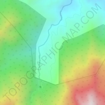
Mullodi topographic map
Interactive map
Click on the map to display elevation.
About this map
Name: Mullodi topographic map, elevation, terrain.
Average elevation: 1,114 m
Minimum elevation: 845 m
Maximum elevation: 1,555 m
Other topographic maps
Click on a map to view its topography, its elevation and its terrain.
Krishnaraja Sagara
India > Karnataka > Krishnarajanagara taluk > Yaraganahalli
Average elevation: 769 m
Ranganathittu Bird Sanctuary
India > Karnataka > Srirangapattana taluk > Krishnarajasagara
Average elevation: 736 m
Krishnaraja Sagara Dam
India > Karnataka > Srirangapattana taluk > Krishnarajasagara
Average elevation: 740 m
Uttara Kannada
The district's high rainfall supports lush forests, which cover approximately 70% of the district. The Malabar Coast moist forests ecoregion lies in a narrow strip between the Arabian Sea and the foothills of the Western Ghats up to 250 meters elevation. These forests have been almost completely converted to…
Average elevation: 364 m
Sahakara Nagar CQAL Kids Park
India > Karnataka > Yelahanka taluku > Bengaluru
Average elevation: 912 m
Ramanagara
Ramanagara is approximately 50 km southwest of Bengaluru. The district shares borders with the districts of Bangalore Urban in the east, Bangalore Rural in the North-east, Tumkur in the North-west, Mandya in the west and Chamarajanagar in the south-west and Krishnagiri district of Tamilnadu state in the south.…
Average elevation: 764 m
Halanayakanahalli Lake
India > Karnataka > Bangalore East > Chikkanayakanahalli
Average elevation: 894 m