
Make a donation
Gear up for your next adventure:
As an Amazon Associate, this site earns from qualifying purchases at no extra cost to you.
Hanagal taluk topographic map
Click on the map to display elevation.
Make a donation
Gear up for your next adventure:
As an Amazon Associate, this site earns from qualifying purchases at no extra cost to you.
About this map
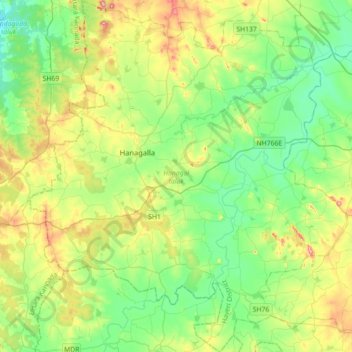
Name: Hanagal taluk topographic map, elevation, terrain.
Location: Hanagal taluk, Haveri District, Karnataka, India (14.57007 75.01513 14.91371 75.33734)
Average elevation: 571 m
Minimum elevation: 512 m
Maximum elevation: 699 m
Make a donation
Gear up for your next adventure:
As an Amazon Associate, this site earns from qualifying purchases at no extra cost to you.
Other topographic maps
Click on a map to view its topography, its elevation and its terrain.
Udupi
India > Karnataka > Udupi taluku
Udupi has an elevation of 27 m (89 ft) above mean sea level. The climate in Udupi is hot in summers and pleasant in winter. During summers (from March to May) the temperature reaches up to 38 °C (100 °F) and in winters (from December to February) it is usually between 32 and 20 °C (90 and 68 °F). As it is…
Average elevation: 17 m
Make a donation
Gear up for your next adventure:
As an Amazon Associate, this site earns from qualifying purchases at no extra cost to you.
Srirangapatna
India > Karnataka > Srirangapattana taluk
Srirangapatna is at 12°25′N 76°42′E / 12.41°N 76.7°E / 12.41; 76.7. It has an average elevation of 679 metres (2227 feet). Srirangapatna Sangama is the confluence of the three holy streams creating the island. Located 27 km upstream from the town is the spectacular Shivanasamudra Falls, the…
Average elevation: 693 m
Make a donation
Gear up for your next adventure:
As an Amazon Associate, this site earns from qualifying purchases at no extra cost to you.
Siruguppa
India > Karnataka > Siruguppa taluku
Siruguppa is located at 15°38′N 76°54′E / 15.63°N 76.9°E / 15.63; 76.9. Located on the Deccan plateau, it has an average elevation of 373 metres (1223 feet). It belongs to the dry inland region of Karnataka with an annual rainfall of 645 mm. The Taluk is bounded in the south by Bellary taluk,…
Average elevation: 372 m
Gauribidanuru
India > Karnataka > Gauribidanuru taluk
Gauribidanur is at 13°37′N 77°31′E / 13.61°N 77.52°E / 13.61; 77.52. It has an average elevation of 694 metres (2276 feet).
Average elevation: 691 m
Make a donation
Gear up for your next adventure:
As an Amazon Associate, this site earns from qualifying purchases at no extra cost to you.
Alnavar
India > Karnataka > Alnavara taluku
Alnavar is located at 15°26′N 74°44′E / 15.43°N 74.73°E / 15.43; 74.73. It has an average elevation of 563 metres (1847 feet). Trains from Bangalore to Vasco da Gama passes through this town.
Average elevation: 575 m
Make a donation
Gear up for your next adventure:
As an Amazon Associate, this site earns from qualifying purchases at no extra cost to you.
Shikaripura
India > Karnataka > Shikaripura taluk
Shikaripur is located at 14°16′N 75°21′E / 14.27°N 75.35°E / 14.27; 75.35. It has an average elevation of 603 m (1978 ft). It lies on tropical forests of Malenadu region. Shikaripura is one of the junction to connect north karnataka to Malenadu. And the river kumadvati flows from the town and…
Average elevation: 610 m
Make a donation
Gear up for your next adventure:
As an Amazon Associate, this site earns from qualifying purchases at no extra cost to you.
Channagiri
India > Karnataka > Channagiri taluku
Channagiri is located at 14°02′N 75°56′E / 14.03°N 75.93°E / 14.03; 75.93. It has an average elevation of 662 metres (2171 feet).
Average elevation: 679 m
Raichur
India > Karnataka > Rayachuru taluku
Raichur is located at 16°12′N 77°22′E / 16.2°N 77.37°E / 16.2; 77.37 on Deccan plateau. It has an average elevation of 407 metres (1335 ft)
Average elevation: 378 m
Make a donation
Gear up for your next adventure:
As an Amazon Associate, this site earns from qualifying purchases at no extra cost to you.
Challakere
India > Karnataka > Challakere taluku
Challakere is located at 14°18′43″N 76°39′04″E / 14.312°N 76.651°E / 14.312; 76.651. It has an average elevation of 585 metres (1919 ft).
Average elevation: 583 m
Make a donation
Gear up for your next adventure:
As an Amazon Associate, this site earns from qualifying purchases at no extra cost to you.
Gokak
India > Karnataka > Gokak taluku
Gokak is second biggest city after Belgaum city in Belgaum district and is surrounded by the Western Ghats. The Ghataprabha River, which has water almost throughout the year, is the chief source of agricultural and drinking water for local people living in the surrounding villages. It has an average elevation…
Average elevation: 593 m
Chincholi
India > Karnataka > Chincholi taluku
Chincholi is located at 17°28′N 77°26′E / 17.47°N 77.43°E / 17.47; 77.43. It has an average elevation of 462 m (1,516 ft). The town is spread over an area of 6 km2 (2.3 sq mi).
Average elevation: 466 m
Make a donation
Gear up for your next adventure:
As an Amazon Associate, this site earns from qualifying purchases at no extra cost to you.
Make a donation
Gear up for your next adventure:
As an Amazon Associate, this site earns from qualifying purchases at no extra cost to you.
Make a donation
Gear up for your next adventure:
As an Amazon Associate, this site earns from qualifying purchases at no extra cost to you.
Make a donation
Gear up for your next adventure:
As an Amazon Associate, this site earns from qualifying purchases at no extra cost to you.
Make a donation
Gear up for your next adventure:
As an Amazon Associate, this site earns from qualifying purchases at no extra cost to you.
Make a donation
Gear up for your next adventure:
As an Amazon Associate, this site earns from qualifying purchases at no extra cost to you.
Make a donation
Gear up for your next adventure:
As an Amazon Associate, this site earns from qualifying purchases at no extra cost to you.
Moodabidri
India > Karnataka > Moodabidri taluk
Its average elevation is 147 metres (482 ft).
Average elevation: 111 m
Bidar
India > Karnataka > Bidar taluku
Bidar is located at 17°54′N 77°30′E / 17.9°N 77.5°E / 17.9; 77.5, lies at a central position in Deccan, a plateau at an elevation of 2300 ft from the sea level. It has common boundaries with Maharashtra and Telangana which is, with the districts of Nizamabad and Medak in Telangana on the East…
Average elevation: 593 m
Make a donation
Gear up for your next adventure:
As an Amazon Associate, this site earns from qualifying purchases at no extra cost to you.
Make a donation
Gear up for your next adventure:
As an Amazon Associate, this site earns from qualifying purchases at no extra cost to you.
Make a donation
Gear up for your next adventure:
As an Amazon Associate, this site earns from qualifying purchases at no extra cost to you.
Make a donation
Gear up for your next adventure:
As an Amazon Associate, this site earns from qualifying purchases at no extra cost to you.
Make a donation
Gear up for your next adventure:
As an Amazon Associate, this site earns from qualifying purchases at no extra cost to you.
Make a donation
Gear up for your next adventure:
As an Amazon Associate, this site earns from qualifying purchases at no extra cost to you.
Make a donation
Gear up for your next adventure:
As an Amazon Associate, this site earns from qualifying purchases at no extra cost to you.
Kalaghatagi
India > Karnataka > Kalaghatagi taluku
Kalghatgi is located at 15°11′N 74°58′E / 15.18°N 74.97°E / 15.18; 74.97. It has an average elevation of 536 metres (1758 feet). Kalghatgi is located 28 km from Hubli and 30 km from Dharwad.The Kalghatgi town is located on National Highway 63 (India) en route from Hubli to Ankola.
Average elevation: 545 m
Make a donation
Gear up for your next adventure:
As an Amazon Associate, this site earns from qualifying purchases at no extra cost to you.
Make a donation
Gear up for your next adventure:
As an Amazon Associate, this site earns from qualifying purchases at no extra cost to you.
Make a donation
Gear up for your next adventure:
As an Amazon Associate, this site earns from qualifying purchases at no extra cost to you.
Make a donation
Gear up for your next adventure:
As an Amazon Associate, this site earns from qualifying purchases at no extra cost to you.