
Penmachno topographic map
Interactive map
Click on the map to display elevation.
About this map
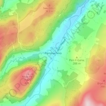
Name: Penmachno topographic map, elevation, terrain.
Location: Penmachno, Conwy, Wales, LL24 0TY, United Kingdom (53.01826 -3.82630 53.05826 -3.78630)
Average elevation: 269 m
Minimum elevation: 137 m
Maximum elevation: 464 m
Conwy trails, hiking, mountain biking, running and outdoor activities
Other topographic maps
Click on a map to view its topography, its elevation and its terrain.