
Old Colwyn topographic map
Click on the map to display elevation.
About this map
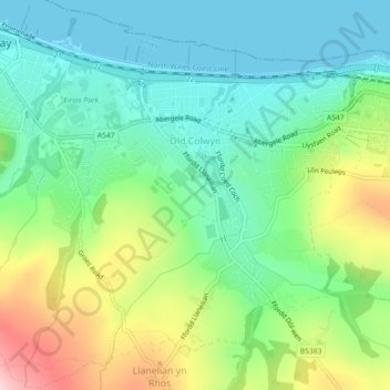
Name: Old Colwyn topographic map, elevation, terrain.
Location: Old Colwyn, Conwy, Wales, United Kingdom (53.27355 -3.71497 53.29591 -3.67180)
Average elevation: 75 m
Minimum elevation: 0 m
Maximum elevation: 235 m
Conwy trails, hiking, mountain biking, running and outdoor activities
Other topographic maps
Click on a map to view its topography, its elevation and its terrain.
Gwyrch Castle Northern Towers
United Kingdom > Wales > Conwy > Llanddulas > Terfyn
Average elevation: 54 m