
Penmaenmawr topographic map
Interactive map
Click on the map to display elevation.
About this map
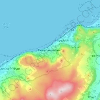
Name: Penmaenmawr topographic map, elevation, terrain.
Location: Penmaenmawr, Conwy, Wales, LL34 6UU, United Kingdom (53.22814 -3.96003 53.30814 -3.88003)
Average elevation: 143 m
Minimum elevation: -1 m
Maximum elevation: 602 m
Conwy trails, hiking, mountain biking, running and outdoor activities
Other topographic maps
Click on a map to view its topography, its elevation and its terrain.