
Polk County topographic map
Interactive map
Click on the map to display elevation.
Polk County
According to the U.S. Census Bureau, the county has a total area of 312 square miles (810 km2), of which 310 square miles (800 km2) is land and 1.8 square miles (4.7 km2) (0.6%) is water. Much of the county is also covered in rolling hills and small mountains, most of which are part of the Piedmont Plateau and the Ridge-and-Valley mountains, which are both smaller sections of the larger Appalachian Mountains. The highest of these small mountains is Shorty mountain near the Unincorporated community of Etna with an elevation of 1,610 ft (491 m) above sea level. The most prominent mountain in the county (as well as the 5th highest) is Signal Mountain in Rockmart with a prominence of 360 ft (110 m) and an elevation of 1,290 ft (393 m) above sea level.
About this map
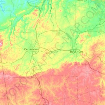
Name: Polk County topographic map, elevation, terrain.
Location: Polk County, Georgia, United States (33.89901 -85.42185 34.09909 -84.92274)
Average elevation: 289 m
Minimum elevation: 168 m
Maximum elevation: 463 m
Other topographic maps
Click on a map to view its topography, its elevation and its terrain.
Vinings
United States > Georgia > Cobb County
Vinings features a varied topography characterized by rolling hills and lush, wooded areas that provide a picturesque backdrop to the community. The area is nestled alongside the Chattahoochee River, which contributes to the gentle slopes and valleys that define the landscape. Elevations in Vinings typically…
Average elevation: 281 m
Stone Mountain
United States > Georgia > DeKalb County
The park is owned by the state of Georgia and is currently managed by Herschend Family Entertainment. At its summit, the elevation is 1,686 feet (514 m) above sea level and 825 feet (251 m) above the surrounding area. Stone Mountain is well known for not only its geology, but also the enormous rock relief on…
Average elevation: 299 m
Honey Ridge Plantation
United States > Georgia > Houston County > Warner Robins
Average elevation: 115 m
Georgia International Horse Park
United States > Georgia > Rockdale County > Conyers
Average elevation: 217 m
Blood Mountain
United States > Georgia > Union County
Blood Mountain is the highest peak on the Georgia section of the Appalachian Trail and the sixth-tallest mountain in Georgia, with an elevation of 4,458 feet (1,359 m). It is located on the border of Lumpkin County with Union County and is within the boundaries of the Chattahoochee National Forest and the…
Average elevation: 1,048 m
Palmetto Pines Mobile Home Park
United States > Georgia > Camden County > Kingsland
Average elevation: 6 m
Pine Ridge Country Club Estates
United States > Georgia > Gwinnett County > Lawrenceville
Average elevation: 323 m