
Dima Hasao District topographic map
Interactive map
Click on the map to display elevation.
About this map
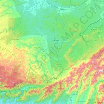
Name: Dima Hasao District topographic map, elevation, terrain.
Location: Dima Hasao District, Assam, India (24.97108 92.52051 25.82894 93.47349)
Average elevation: 529 m
Minimum elevation: 19 m
Maximum elevation: 2,158 m
Other topographic maps
Click on a map to view its topography, its elevation and its terrain.
Namrup
India > Assam > Naharkatiya
Namrup, Naharkatiya, Dibrugarh District, Assam, 786623, India
Average elevation: 133 m
North Lakhimpur
North Lakhimpur, Lakhimpur District, Assam, India
Average elevation: 96 m
South Salmara
South Salmara, South Salmara-Mankachar, Assam, India
Average elevation: 40 m
Udalguri
India > Assam > Udalguri tehsil
Udalguri, Udalguri tehsil, Udalguri district, Assam, 784509, India
Average elevation: 109 m
Jorhat
India > Assam > Jorhat East
Jorhat, Jorhat East, Jorhat District, Assam, 785001, India
Average elevation: 93 m
Umiam River
Umiam River, Donka, West Karbi Anglong, Assam, India
Average elevation: 456 m