
Karlsruhe topographic map
Interactive map
Click on the map to display elevation.
Karlsruhe
The city lies at an altitude between 100 and 322 m (near the communications tower in the suburb of Grünwettersbach). Its geographical coordinates are 49°00′N 8°24′E / 49.000°N 8.400°E / 49.000; 8.400; the 49th parallel runs through the city centre, which puts it at the same latitude as much of the Canada–United States border, the cities Vancouver (Canada), Paris (France), Regensburg (Germany), and Hulunbuir (China). Its course is marked by a stone and painted line in the Stadtgarten (municipal park). The total area of the city is 173.46 km2 (66.97 sq mi), hence it is the 30th largest city in Germany measured by land area. The longest north–south distance is 16.8 km (10.4 mi) and 19.3 km (12.0 mi) in the east–west direction.
About this map
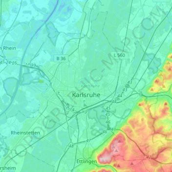
Name: Karlsruhe topographic map, elevation, terrain.
Location: Karlsruhe, Baden-Württemberg, Germany (48.94047 8.27731 49.09128 8.54173)
Average elevation: 132 m
Minimum elevation: 94 m
Maximum elevation: 349 m
Other topographic maps
Click on a map to view its topography, its elevation and its terrain.
Stuttgart
Germany > Baden-Württemberg > Stuttgart
Stuttgart covers an area of 207.35 km2 (80 sq mi) and sits at elevation ranging from 207 m (679 ft) above sea level by the Neckar river to 549 m (1,801 ft) on Bernhartshöhe hill – something rather unique in large German cities. The most prominent elevated locales in Stuttgart are the Birkenkopf (511 m…
Average elevation: 353 m
Hohenhaslach
Germany > Baden-Württemberg > Landkreis Ludwigsburg > Sachsenheim
Average elevation: 281 m
Nördlinger Stein
Germany > Baden-Württemberg > Landkreis Heidenheim > Königsbronn > Zahnberg
Average elevation: 586 m
Obergieß
Germany > Baden-Württemberg > Ortenaukreis > Hornberg > Niederwasser
Average elevation: 717 m
Kapfenburg
Germany > Baden-Württemberg > Ostalbkreis > Lauchheim > Domäne Kapfenburg
Average elevation: 559 m
Hauenstein
Germany > Baden-Württemberg > Landkreis Waldshut > Laufenburg (Baden) > Luttingen
Average elevation: 383 m
Bad Teinach
Germany > Baden-Württemberg > Landkreis Calw
The township (Stadt) of Bad Teinach-Zavelstein is located at the center of the district of Calw, in Baden-Württemberg, one of the 16 States of the Federal Republic of Germany. Bad Teinach-Zavelstein's municipal area rests upon the plateau of the Enz and Nagold rivers, a landscape defined by severe river…
Average elevation: 557 m
Mattenhof
Germany > Baden-Württemberg > Ortenaukreis > Gutach (Schwarzwaldbahn)
Average elevation: 402 m
Friedrichsturm
Germany > Baden-Württemberg > Landkreis Freudenstadt > Freudenstadt
Average elevation: 753 m
Kleinallmerspann
Germany > Baden-Württemberg > Landkreis Schwäbisch Hall > Kirchberg an der Jagst
Average elevation: 430 m
Großherrischwand
Germany > Baden-Württemberg > Landkreis Waldshut > Herrischried
Average elevation: 920 m
Rielingshausen
Germany > Baden-Württemberg > Landkreis Ludwigsburg > Marbach am Neckar
Average elevation: 291 m
Nussdorf
Germany > Baden-Württemberg > Landkreis Ludwigsburg
The municipality (Gemeinde) of Eberdingen is located at the western extremity of the district of Ludwigsburg, in the German state of Baden-Württemberg, along its border with the districts of Böblingen and the Enz. Eberdingen is physically located in the basin of [de] the Neckar. Elevation above sea level in…
Average elevation: 321 m
Obertüllingen
Germany > Baden-Württemberg > Landkreis Lörrach > Lörrach > Untertüllingen
Average elevation: 307 m
Ground Zero
Germany > Baden-Württemberg > Landkreis Ludwigsburg > Ludwigsburg
Average elevation: 304 m
Sinsheim-Steinsfurt / Insenbach
Germany > Baden-Württemberg > Rhein-Neckar-Kreis > Sinsheim
Average elevation: 204 m
Rickelshausen
Germany > Baden-Württemberg > Landkreis Konstanz > Radolfzell am Bodensee > Böhringen
Average elevation: 406 m
Dietenbach
Germany > Baden-Württemberg > Landkreis Breisgau-Hochschwarzwald > Kirchzarten (Kernort) > Kirchzarten
Average elevation: 482 m
Hopfenweiler
Germany > Baden-Württemberg > Landkreis Ravensburg > Bad Waldsee
Average elevation: 618 m
Bad Rippoldsau
Germany > Baden-Württemberg > Landkreis Freudenstadt > Bad Rippoldsau-Schapbach
Average elevation: 716 m
Bleiche
Germany > Baden-Württemberg > Landkreis Konstanz > Stockach > Hindelwangen
Average elevation: 567 m
Rheintal
Germany > Baden-Württemberg > Landkreis Breisgau-Hochschwarzwald > Müllheim im Markgräflerland
Average elevation: 424 m
Inselbad
Germany > Baden-Württemberg > Alb-Donau-Kreis > Munderkingen > Algershofen
Average elevation: 525 m
Untergreifenstein
Germany > Baden-Württemberg > Landkreis Reutlingen > Lichtenstein
Average elevation: 661 m
Wolfenweiler
Germany > Baden-Württemberg > Landkreis Breisgau-Hochschwarzwald
Average elevation: 261 m
Deuchelried
Germany > Baden-Württemberg > Landkreis Ravensburg > Wangen im Allgäu
Average elevation: 604 m
Kleinwinnaden
Germany > Baden-Württemberg > Landkreis Biberach > Bad Schussenried
Average elevation: 584 m
Alte Ölmühle
Germany > Baden-Württemberg > Landkreis Konstanz > Engen > Anselfingen
Average elevation: 561 m
Elbenschwand
Germany > Baden-Württemberg > Landkreis Lörrach > Kleines Wiesental
Average elevation: 789 m
Merklingen
Germany > Baden-Württemberg > Landkreis Böblingen > Weil der Stadt
Average elevation: 436 m
Dettenheim (Baden)
Germany > Baden-Württemberg > Landkreis Karlsruhe > Dettenheim
Average elevation: 100 m
Ruine Reußenstein
Germany > Baden-Württemberg > Landkreis Esslingen > Neidlingen
Average elevation: 675 m
Burg
Germany > Baden-Württemberg > Landkreis Biberach > Bad Schussenried > Otterswang
Average elevation: 611 m
Holzbachtal
Germany > Baden-Württemberg > Enzkreis > Straubenhardt > Langenalb
Average elevation: 449 m
Leipferdingen Bahnstation
Germany > Baden-Württemberg > Landkreis Tuttlingen > Geisingen > Leipferdingen
Average elevation: 750 m