
Van Buren County topographic map
Interactive map
Click on the map to display elevation.
About this map
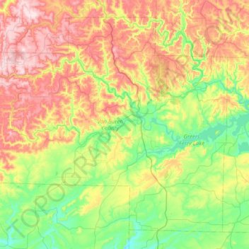
Name: Van Buren County topographic map, elevation, terrain.
Location: Van Buren County, Arkansas, United States (35.36333 -92.84992 35.79129 -92.24075)
Average elevation: 296 m
Minimum elevation: 107 m
Maximum elevation: 615 m
Other topographic maps
Click on a map to view its topography, its elevation and its terrain.
Scotland
United States > Arkansas > Van Buren County
Scotland, Van Buren County, Arkansas, 72141, United States
Average elevation: 242 m
Clinton
United States > Arkansas > Van Buren County
Clinton, Van Buren County, Arkansas, 72031, United States
Average elevation: 230 m
Shirley
United States > Arkansas > Van Buren County
Shirley, Van Buren County, Arkansas, 72153, United States
Average elevation: 205 m
Fairfield Bay
United States > Arkansas > Van Buren County > Fairfield Bay
Fairfield Bay, Van Buren County, Arkansas, 72088, United States
Average elevation: 230 m
Fairfield Bay
United States > Arkansas > Van Buren County > Fairfield Bay > Fairfield Bay
Fairfield Bay, Van Buren County, Arkansas, 72088, United States
Average elevation: 225 m