Geolocate

Kralendijk topographic map

Interactive map

Click on the map to display elevation.

About this map

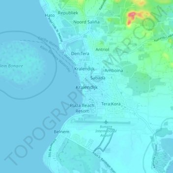
Name: Kralendijk topographic map, elevation, terrain.

Location: Kralendijk, Bonaire, Netherlands, 1234 AB, Netherlands (12.10729 -68.31402 12.18729 -68.23402)

Average elevation: 9 m

Minimum elevation: -2 m

Maximum elevation: 114 m

Other topographic maps

Click on a map to view its topography, its elevation and its terrain.

Amsterdam

Netherlands > North Holland

Amsterdam is located in the Western Netherlands, in the province of North Holland, the capital of which is not Amsterdam, but rather Haarlem. The river Amstel ends in the city centre and connects to a large number of canals that eventually terminate in the IJ. Amsterdam's elevation is about −2 m (−6.6 ft)…

Average elevation: 0 m

Eindhoven

Netherlands > North Brabant

The villages and city that make up modern Eindhoven were originally built on sandy elevations between the Dommel, Gender and Tongelreep rivers. Beginning in the 19th century, the basins of the rivers themselves have also been used as housing land, resulting in occasional flooding in the city centre. Partly to…

Average elevation: 20 m

Arnhem

Netherlands > Gelderland

Average elevation: 36 m

Holland

Netherlands

Average elevation: 2 m

Groningen

Netherlands > Groningen

Average elevation: 1 m

Limburg

Netherlands

Average elevation: 49 m

Rotterdam

Netherlands > South Holland

Average elevation: 0 m

Schipborg

Netherlands > Drenthe

Average elevation: 8 m

Maastricht

Netherlands > Limburg

Average elevation: 72 m

Barendrecht

Netherlands > South Holland > Barendrecht

Average elevation: 1 m

Bonaire

Netherlands

While Bonaire has some hills and variations in altitude, Klein Bonaire's surface is quite level and just about two meters above sea level. Because Klein Bonaire is as yet undeveloped, the fringing reef system surrounding Klein Bonaire is pristine.

Average elevation: 1 m

The Hague

Netherlands > South Holland

Average elevation: 2 m

Nijmegen

Netherlands > Gelderland > Nijmegen

Average elevation: 19 m

Echteld

Netherlands > Gelderland

Average elevation: 7 m

Europoort

Netherlands > South Holland

Average elevation: 2 m

Gerkesklooster

Netherlands > Frisia

Average elevation: 0 m

Barendrecht

Netherlands > South Holland

Average elevation: 1 m

Noordlaren

Netherlands > Groningen

Average elevation: 3 m

Raalte

Netherlands > Overijssel

Average elevation: 10 m

Zaan

Netherlands > North Holland > Zaandam

Average elevation: 2 m

Haarlem

Netherlands > North Holland > Haarlem

Average elevation: 3 m

Vriescheloo

Netherlands > Groningen

Average elevation: 1 m

Monster

Netherlands > South Holland

Average elevation: 1 m

Steenwijk

Netherlands > Overijssel

Average elevation: 4 m

Deurne

Netherlands > North Brabant

Average elevation: 29 m

Bloemendaal

Netherlands > North Holland

Average elevation: 3 m

Oostvoorne

Netherlands > South Holland

Average elevation: 2 m

Naaldwijk

Netherlands > South Holland

Average elevation: 1 m

Ouddorp

Netherlands > South Holland

Average elevation: 0 m

Spijkenisse

Netherlands > South Holland

Average elevation: 1 m

Valkenburg

Netherlands > Limburg

Average elevation: 123 m

Ede

Netherlands > Gelderland

Average elevation: 30 m

Heenvliet

Netherlands > South Holland

Average elevation: 1 m

Delft

Netherlands > South Holland

Average elevation: 0 m

Wassenaar

Netherlands > South Holland > Wassenaar

Average elevation: 3 m

Bussum

Netherlands > North Holland

Average elevation: 5 m

Sint Eustatius

Netherlands

Sint Eustatius is 6 miles (10 km) long and up to 3 miles (5 km) wide. Topographically, the island is saddle-shaped, with the 602-metre (1,975 ft) high dormant volcano Quill (Mount Mazinga), (from Dutch kuil, meaning 'pit'—originally referring to its crater) to the southeast and the smaller summits of Signal…

Average elevation: 12 m

Sonsbeek

Netherlands > Gelderland > Arnhem

Average elevation: 43 m

Haarlem

Netherlands > North Holland > Haarlem

Average elevation: 3 m

Otterlo

Netherlands > Gelderland

Average elevation: 32 m

Kerkrade

Netherlands > Limburg

Average elevation: 139 m

Arnhem

Netherlands > Gelderland

Average elevation: 36 m

Sittard

Netherlands > Limburg

Average elevation: 52 m

Nijkerk

Netherlands > Gelderland

Average elevation: 4 m

Utrecht

Netherlands > Utrecht

Average elevation: 3 m

Deventer

Netherlands > Overijssel

Average elevation: 8 m

Mook

Netherlands > Limburg

Average elevation: 29 m

Marken

Netherlands > North Holland

Average elevation: 0 m

Teylingen

Netherlands > South Holland

Average elevation: 0 m

Amersfoort

Netherlands > Utrecht

The construction of the tower and the church was started in 1444. The church was destroyed by an explosion in 1787, but the tower survived, and the layout of the church still can be discerned today through the use of different types of stone in the pavement of the open space that was created. It is now the…

Average elevation: 6 m

Blaricum

Netherlands > North Holland

Dutch Topographic map of the municipality of Blaricum, June 2015.

Average elevation: 4 m

Heerde

Netherlands > Gelderland

Average elevation: 14 m

Eindhoven

Netherlands > North Brabant

The villages and city that make up modern Eindhoven were originally built on sandy elevations between the Dommel, Gender and Tongelreep rivers. Beginning in the 19th century, the basins of the rivers themselves have also been used as housing land, resulting in occasional flooding in the city centre. Partly to…

Average elevation: 20 m

Eethen

Netherlands > North Brabant

Average elevation: 1 m

Veenendaal

Netherlands > Utrecht > Veenendaal

Average elevation: 11 m

Sluiskil

Netherlands > Zeeland

Average elevation: 1 m

Aalsmeer

Netherlands > North Holland

Average elevation: -2 m

Teteringen

Netherlands > North Brabant

Average elevation: 5 m

Wolvega

Netherlands > Frisia

Average elevation: 2 m

Amsterdam

Netherlands > North Holland

Amsterdam is located in the Western Netherlands, in the province of North Holland, the capital of which is not Amsterdam, but rather Haarlem. The river Amstel ends in the city centre and connects to a large number of canals that eventually terminate in the IJ. Amsterdam's elevation is about −2 m (−6.6 ft)…

Average elevation: 0 m

Aalsmeer

Netherlands > North Holland

Average elevation: -2 m

Amsterdam

Netherlands > North Holland

Amsterdam is located in the Western Netherlands, in the province of North Holland, the capital of which is not Amsterdam, but rather Haarlem. The river Amstel ends in the city centre and connects to a large number of canals that eventually terminate in the IJ. Amsterdam's elevation is about −2 m (−6.6 ft)…

Average elevation: 0 m

Flevoland

Netherlands

Average elevation: 1 m

It Heidenskip

Netherlands > Frisia

Average elevation: -2 m

Arnhem

Netherlands > Gelderland

Average elevation: 38 m

Feanwâlden

Netherlands > Frisia

Average elevation: 0 m

Aerdenhout

Netherlands > North Holland

Average elevation: 6 m

Gouda

Netherlands > South Holland

Average elevation: -1 m

Zuidplas

Netherlands > South Holland

Dutch Topographic map of the municipality of Zuidplas, September 2014

Average elevation: -3 m

Frisia

Netherlands

Average elevation: 1 m

Vlissingen

Netherlands > Zeeland

Topographic map of Vlissingen (city), Sept. 2014

Average elevation: 0 m

Odoorn

Netherlands > Drenthe

Average elevation: 22 m

Wijnaldum

Netherlands > Frisia

Average elevation: 0 m

South Holland

Netherlands

Average elevation: 0 m

Hattem

Netherlands > Gelderland

Average elevation: 7 m

South Holland

Netherlands

Average elevation: 0 m

Weert

Netherlands > Limburg

Average elevation: 33 m

Leiden

Netherlands > South Holland

Average elevation: 1 m

Wijk bij Duurstede

Netherlands > Utrecht

Dutch Topographic map of the municipality of Wijk bij Duurstede, 2013.

Average elevation: 7 m

Berkenwoude

Netherlands > South Holland

Average elevation: -1 m

Roosendaal

Netherlands > North Brabant

Average elevation: 5 m

Rijswijk

Netherlands > South Holland

Average elevation: 2 m

Holten

Netherlands > Overijssel

Average elevation: 17 m

Hoogersmilde

Netherlands > Drenthe

Average elevation: 12 m

Badhoevedorp

Netherlands > North Holland

Average elevation: -2 m

Gulpen

Netherlands > Limburg

Average elevation: 141 m

Beers NB

Netherlands > North Brabant

Average elevation: 11 m

Boschplaat

Netherlands > Frisia > Oosterend

Average elevation: 1 m

Urk

Netherlands > Flevoland

Average elevation: -1 m

Bergen

Netherlands > North Holland

Average elevation: 1 m

Sint Eustatius

Netherlands

Sint Eustatius is 6 miles (10 km) long and up to 3 miles (5 km) wide. Topographically, the island is saddle-shaped, with the 602-metre (1,975 ft) high dormant volcano Quill (Mount Mazinga), (from Dutch kuil, meaning 'pit'—originally referring to its crater) to the southeast and the smaller summits of Signal…

Average elevation: 12 m

Eindhoven

Netherlands > North Brabant

The villages and city that make up modern Eindhoven were originally built on sandy elevations between the Dommel, Gender and Tongelreep rivers. Beginning in the 19th century, the basins of the rivers themselves have also been used as housing land, resulting in occasional flooding in the city centre. Partly to…

Average elevation: 20 m

Cadier en Keer

Netherlands > Limburg

Average elevation: 115 m

Maassluis

Netherlands > South Holland > Maassluis

Average elevation: 2 m

Noordwijk

Netherlands > South Holland

Average elevation: 1 m

Keizersgracht

Netherlands > North Holland > Amsterdam

Average elevation: 6 m

Aruba

Netherlands

Average elevation: 11 m

Hoogkerk

Netherlands > Groningen > Groningen

Average elevation: 1 m