Geolocate

Caithness topographic map

Click on the map to display elevation.

Caithness

Caithness extends about 30 miles (48 km) north-south and about 30 miles (48 km) east-west, with a roughly triangular-shaped area of about 712 sq mi (1,840 km2). The topography is generally flat, in contrast to the majority of the remainder of the North of Scotland. Until the latter part of the 20th century when large areas were planted in conifers, this level profile was rendered still more striking by the almost total absence of woodland.

Wikipedia (CC-BY-SA 3.0)

About this map

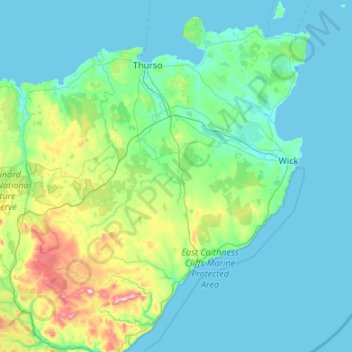
Name: Caithness topographic map, elevation, terrain.

Location: Caithness, Scotland, United Kingdom (58.13601 -3.85819 58.69752 -3.02396)

Average elevation: 79 m

Minimum elevation: 0 m

Maximum elevation: 649 m

Scotland trails, hiking, mountain biking, running and outdoor activities

Other topographic maps

Click on a map to view its topography, its elevation and its terrain.

Edinburgh

United Kingdom > Scotland > Edinburgh

Some have called Edinburgh the Athens of the North for a variety of reasons. The earliest comparison between the two cities showed that they had a similar topography, with the Castle Rock of Edinburgh performing a similar role to the Athenian Acropolis. Both of them had flatter, fertile agricultural land…

Average elevation: 104 m

Glasgow

United Kingdom > Scotland > Glasgow City

Glasgow itself was reputed to have been founded by the Christian missionary Saint Mungo in the 6th century. He established a church on the Molendinar Burn, where the present Glasgow Cathedral stands, and in the following years Glasgow became a religious centre. Glasgow grew over the following centuries. The…

Average elevation: 128 m

Ben Nevis

United Kingdom > Scotland > Highland

Ben Nevis has a highland (alpine) maritime (oceanic) polar climate (ET climate in the Köppen classification). Ben Nevis's elevation, maritime location and topography frequently lead to cool and cloudy weather conditions, which can pose a danger to ill-equipped walkers. According to the observations carried…

Average elevation: 912 m

Aberdeen

United Kingdom > Scotland > Aberdeen

Two weather stations collect climate data for the area, Aberdeen/Dyce Airport, and Craibstone. Both are about 4 1⁄2 miles (7 km) to the north west of the city centre, and given that they are in close proximity to each other, exhibit very similar climatic regimes. Dyce tends to have marginally warmer daytime…

Average elevation: 52 m

Pitlochry

United Kingdom > Scotland > Perth and Kinross

Average elevation: 276 m

Livingston

United Kingdom > Scotland > West Lothian

Average elevation: 158 m

Langdale

United Kingdom > Scotland > Highland

Average elevation: 115 m

Muirburn

United Kingdom > Scotland > Scottish Borders

Average elevation: 301 m

Oban

United Kingdom > Scotland > Argyll and Bute

Average elevation: 52 m

The Campsie Fells

United Kingdom > Scotland

Average elevation: 431 m

Scottish Highlands

United Kingdom > Scotland > Highland

The entire region was covered by ice sheets during the Pleistocene ice ages, save perhaps for a few nunataks. The complex geomorphology includes incised valleys and lochs carved by the action of mountain streams and ice, and a topography of irregularly distributed mountains whose summits have similar heights…

Average elevation: 907 m

Kinlochewe

United Kingdom > Scotland > Highland

Average elevation: 153 m

Coulport

United Kingdom > Scotland > Argyll and Bute

Average elevation: 61 m

Ayr

United Kingdom > Scotland > South Ayrshire

Average elevation: 18 m

Hawick

United Kingdom > Scotland > Scottish Borders

Average elevation: 199 m

Ailsa Craig

United Kingdom > Scotland

In a small glen above Ailsa Castle, a small freshwater body known as the Garry Loch is located at an altitude of 247 m (810 ft), with a depth of at least 17 feet.

Average elevation: 14 m

Grey Mare's Tail

United Kingdom > Scotland

Average elevation: 466 m

Helmsdale

United Kingdom > Scotland > Highland

Average elevation: 64 m

Cowie

United Kingdom > Scotland > Stirling

Average elevation: 30 m

Glencoe

United Kingdom > Scotland > Highland

Average elevation: 114 m

Thurso

United Kingdom > Scotland > Highland

Average elevation: 25 m

Fort William

United Kingdom > Scotland > Highland

Fort William has an oceanic climate (Cfb) with moderate, but generally cool, temperatures and abundant precipitation. In the towns immediate vicinity, there are significant variations in elevation, which leads to some uninhabited areas near the town having a subpolar oceanic climate (Cfc), or, at the absolute…

Average elevation: 122 m

Dundee

United Kingdom > Scotland > Dundee City

Dundee sits on the north bank of the Firth of Tay on the eastern, North Sea Coast of Scotland. The city lies 36.1 miles (58 km) NNE of Edinburgh and 360.6 miles (580 km) NNW of London. The built-up area occupies a roughly rectangular shape 8.3 miles (13 km) long by 2.5 miles (4 km) wide, aligned in an east to…

Average elevation: 82 m

Dunbar

United Kingdom > Scotland > East Lothian

Average elevation: 24 m

Waterloo

United Kingdom > Scotland > Perth and Kinross

Average elevation: 115 m

Kenknock

United Kingdom > Scotland > Stirling

Average elevation: 434 m

Kilwinning

United Kingdom > Scotland > North Ayrshire

Average elevation: 36 m

Nairn

United Kingdom > Scotland > Highland

Average elevation: 18 m

Nethy Bridge

United Kingdom > Scotland > Highland

Average elevation: 230 m

Fens

United Kingdom > Scotland > Scottish Borders > St Boswells

Average elevation: 96 m

Auchencorth Moss

United Kingdom > Scotland

Average elevation: 281 m

River Kerry

United Kingdom > Scotland

Average elevation: 118 m

Melness

United Kingdom > Scotland > Highland

Average elevation: 39 m

Clachan

United Kingdom > Scotland > Argyll and Bute

Average elevation: 75 m

Glasgow

United Kingdom > Scotland > Glasgow City

Glasgow itself was reputed to have been founded by the Christian missionary Saint Mungo in the 6th century. He established a church on the Molendinar Burn, where the present Glasgow Cathedral stands, and in the following years Glasgow became a religious centre. Glasgow grew over the following centuries as part…

Average elevation: 128 m

Harelaw

United Kingdom > Scotland > Scottish Borders > Chirnside

Average elevation: 90 m

Northwest Highlands

United Kingdom > Scotland > Highland

Considering its high northerly latitude of about 57 to 58 degrees north and the mountainous terrain, the climate is mild, moderated by the warming influence of the North Atlantic Drift which is a powerful warm western boundary current within the Atlantic Ocean that extends the Gulf Stream northeastward. At low…

Average elevation: 897 m

St Magnus' Bay

United Kingdom > Scotland

Average elevation: 6 m

Argyll and Bute

United Kingdom > Scotland

Average elevation: 683 m

Western Isles

United Kingdom > Scotland

Average elevation: 23 m

Ayrshire

United Kingdom > Scotland

Average elevation: 141 m

Inchmickery

United Kingdom > Scotland

Average elevation: 0 m

Iona

United Kingdom > Scotland

Average elevation: 9 m

Banffshire

United Kingdom > Scotland

Average elevation: 191 m

Stirlingshire

United Kingdom > Scotland

Average elevation: 222 m

Mull of Kintyre

United Kingdom > Scotland

Ailsa Craig and the County Antrim coast of Ulster and Rathlin Island are all clearly visible from the Mull. On clearer days it is also possible to make out Malin Head in Inishowen in County Donegal in the west of Ulster, and the Ayrshire coast on the other side of Ailsa Craig. Other islands in the Firth of…

Average elevation: 84 m

Glen Dochart

United Kingdom > Scotland

Average elevation: 469 m

Denton Burn

United Kingdom > Scotland

Average elevation: 154 m

Taynish Island

United Kingdom > Scotland

Average elevation: 11 m

Devil's Beef Tub

United Kingdom > Scotland

Average elevation: 376 m

Meall Aundrary

United Kingdom > Scotland

Average elevation: 194 m

Burian Hole

United Kingdom > Scotland

Average elevation: 36 m

Papa

United Kingdom > Scotland

Average elevation: 2 m

Sgùrr na Stri

United Kingdom > Scotland

Average elevation: 92 m

Braid Hill

United Kingdom > Scotland

Average elevation: 353 m

Loch Urigill

United Kingdom > Scotland

Average elevation: 172 m

Buachaille Etive Mor

United Kingdom > Scotland

Average elevation: 585 m

Highland

United Kingdom > Scotland

Average elevation: 402 m

Glen Croe

United Kingdom > Scotland

Average elevation: 355 m

Rothes

United Kingdom > Scotland > Moray

Average elevation: 139 m

Inverness-shire

United Kingdom > Scotland

Average elevation: 333 m

Craik

United Kingdom > Scotland > Scottish Borders

Average elevation: 289 m

Ben Loyal

United Kingdom > Scotland > Highland

Average elevation: 441 m

Glenmore

United Kingdom > Scotland > Highland

Average elevation: 200 m

Barrnacarry Bay

United Kingdom > Scotland

Average elevation: 32 m

Garve

United Kingdom > Scotland > Highland

Average elevation: 169 m

Sciberscross

United Kingdom > Scotland > Highland

Average elevation: 168 m

Strontian

United Kingdom > Scotland > Highland

Average elevation: 97 m

Bankhead of Kirkbuddo

United Kingdom > Scotland > Angus

Average elevation: 159 m

Beauly

United Kingdom > Scotland > Highland

Average elevation: 71 m

Snap

United Kingdom > Scotland

Average elevation: 3 m

Balallan

United Kingdom > Scotland > Western Isles

Average elevation: 36 m

Mallaig

United Kingdom > Scotland > Highland

Average elevation: 25 m

Cousland

United Kingdom > Scotland > Midlothian

Average elevation: 122 m

Lanarkshire

United Kingdom > Scotland

Average elevation: 183 m

Fogwatt

United Kingdom > Scotland > Moray

Average elevation: 110 m

Rubha nam Bùthan

United Kingdom > Scotland

Average elevation: 15 m

Ben Donich

United Kingdom > Scotland > Argyll and Bute

Average elevation: 518 m

Beinn Mheadhonach

United Kingdom > Scotland > Highland

Average elevation: 336 m

Creag a' Mhaim

United Kingdom > Scotland > Highland

Average elevation: 562 m

The Minch

United Kingdom > Scotland

Average elevation: 63 m

Firth of Clyde

United Kingdom > Scotland

Average elevation: 0 m

Glenbuck

United Kingdom > Scotland > East Ayrshire

Average elevation: 321 m

Falkirk

United Kingdom > Scotland > Falkirk

Falkirk is located in an area of undulating topography between the Slamannan Plateau and the upper reaches of the Firth of Forth. The area to the north of Falkirk is part of the floodplain of the River Carron. Two tributaries of the River Carron - the East Burn and the West Burn flow through the town and form…

Average elevation: 69 m

Dunkeld

United Kingdom > Scotland > Perth and Kinross

Average elevation: 190 m

Gear up for your next adventure:

🧗Locking Carabiners - Secure gear to your pack or for light technical use
🛌Sleeping Bags - Warm and packable sleeping bags for outdoor nights
🧼Technical Clothing Wash - Special soap to clean and restore waterproof membranes
🛰️Handheld GPS Devices - Reliable GPS units for hiking and outdoor navigation
🕶️Glacier Goggles - Maximum protection for high-altitude snow topography

As an Amazon Associate, this site earns from qualifying purchases at no extra cost to you.