Geolocate

Snap topographic map

Click on the map to display elevation.
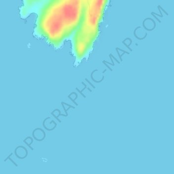
About this map

Name: Snap topographic map, elevation, terrain.

Location: Snap, Scotland, United Kingdom (60.16115 -1.41833 60.16156 -1.41778)

Average elevation: 3 m

Minimum elevation: 0 m

Maximum elevation: 56 m

Scotland trails, hiking, mountain biking, running and outdoor activities

Other topographic maps

Click on a map to view its topography, its elevation and its terrain.

Edinburgh

United Kingdom > Scotland > Edinburgh

Some have called Edinburgh the Athens of the North for a variety of reasons. The earliest comparison between the two cities showed that they had a similar topography, with the Castle Rock of Edinburgh performing a similar role to the Athenian Acropolis. Both of them had flatter, fertile agricultural land…

Average elevation: 104 m

Glasgow

United Kingdom > Scotland > Glasgow City

Glasgow itself was reputed to have been founded by the Christian missionary Saint Mungo in the 6th century. He established a church on the Molendinar Burn, where the present Glasgow Cathedral stands, and in the following years Glasgow became a religious centre. Glasgow grew over the following centuries. The…

Average elevation: 128 m

City of Edinburgh

United Kingdom > Scotland

Edinburgh has been popularly called the Athens of the North since the early 19th century. References to Athens, such as Athens of Britain and Modern Athens, had been made as early as the 1760s. The similarities were seen to be topographical but also intellectual. Edinburgh's Castle Rock reminded returning…

Average elevation: 118 m

Skye

United Kingdom > Scotland > Highland

Beyond Loch Snizort to the west of Trotternish is the Waternish peninsula, which ends in Ardmore Point's double rock arch. Duirinish peninsula is separated from Waternish by Loch Dunvegan, which contains the island of Isay. It is ringed by sea cliffs that reach 296 metres (971 feet) on the west at Waterstein…

Average elevation: 63 m

Ben Nevis

United Kingdom > Scotland > Highland

Ben Nevis has a highland (alpine) maritime (oceanic) polar climate (ET climate in the Köppen classification). Ben Nevis's elevation, maritime location and topography frequently lead to cool and cloudy weather conditions, which can pose a danger to ill-equipped walkers. According to the observations carried…

Average elevation: 912 m

Aberdeen City

United Kingdom > Scotland

Two weather stations collect climate data for the area, Aberdeen/Dyce Airport, and Craibstone. Both are about 4+1⁄2 miles (7 km) to the north west of the city centre, and given that they are in close proximity to each other, exhibit very similar climatic regimes. Dyce tends to have marginally warmer daytime…

Average elevation: 46 m

Lewis and Harris

United Kingdom > Scotland

Average elevation: 28 m

Inverness

United Kingdom > Scotland > Highland

Average elevation: 163 m

Glasgow City

United Kingdom > Scotland

Average elevation: 64 m

Highland

United Kingdom > Scotland

Average elevation: 183 m

Dumfries and Galloway

United Kingdom > Scotland

Average elevation: 163 m

Moray

United Kingdom > Scotland

Average elevation: 280 m

Scottish Highlands

United Kingdom > Scotland > Highland

The entire region was covered by ice sheets during the Pleistocene ice ages, save perhaps for a few nunataks. The complex geomorphology includes incised valleys and lochs carved by the action of mountain streams and ice, and a topography of irregularly distributed mountains whose summits have similar heights…

Average elevation: 907 m

Loch Lomond and The Trossachs National Park

United Kingdom > Scotland > Stirling

The park straddles the Highland Boundary Fault, which divides it into two distinct regions - lowland and highland - that differ in underlying geology, soil types and topography. The change in rock type can most clearly be seen at Loch Lomond itself, as the fault runs across the islands of Inchmurrin, Creinch,…

Average elevation: 291 m

Banchory

United Kingdom > Scotland > Aberdeenshire

Average elevation: 117 m

North Berwick

United Kingdom > Scotland > East Lothian

Average elevation: 21 m

Neilston

United Kingdom > Scotland > East Renfrewshire

The topography of the areas around Neilston are varied. To the east, the land is relatively flat, but to the south and west it is steeper, rising to heights of 400–900 ft (122–274 m) above the level of the River Clyde. The highest points in the surrounding areas are Neilston Pad and the Corkendale-law, at…

Average elevation: 149 m

Isle of Rum

United Kingdom > Scotland > Highland > Kinloch

The island's relief is spectacular, a 19th-century commentator remarking that "the interior is one heap of rude mountains, scarcely possessing an acre of level land". This combination of geology and topography make for less than ideal agricultural conditions, and it is doubtful that more than one tenth of the…

Average elevation: 118 m

Sanday

United Kingdom > Scotland > Orkney Islands > Kettletoft

In the mid-17th century an annexe to Blaeu's Atlas Novus of Scotland recorded that Sanday's low lying topography meant that "shipwreck often occurs to those who sail there at night. The inhabitants of Sanday earnestly and often desire this to happen, so that they get a supply of material for fire from the…

Average elevation: 2 m

Northfield

United Kingdom > Scotland > Aberdeen City

Average elevation: 91 m

Kilsyth

United Kingdom > Scotland > North Lanarkshire

Historically part of Stirlingshire, Kilsyth is at an elevation of 200 feet (60 metres) above sea level and occupies a narrow strip of land between the Kilsyth Hills to the north and the River Kelvin to the south. To the east and west it is bordered by marshland and bogs. The centre of the town is close to the…

Average elevation: 161 m

Ellon

United Kingdom > Scotland > Aberdeenshire

Average elevation: 42 m

Rogart

United Kingdom > Scotland > Highland

Average elevation: 236 m

Moray

United Kingdom > Scotland

Average elevation: 281 m

Aberdeen

United Kingdom > Scotland > Aberdeen

Two weather stations collect climate data for the area, Aberdeen/Dyce Airport, and Craibstone. Both are about 4 1⁄2 miles (7 km) to the north west of the city centre, and given that they are in close proximity to each other, exhibit very similar climatic regimes. Dyce tends to have marginally warmer daytime…

Average elevation: 52 m

Shetland

United Kingdom > Scotland

Walter Scott's 1822 novel The Pirate is set in "a remote part of Shetland", and was inspired by his 1814 visit to the islands. The name Jarlshof meaning "Earl's Mansion" is a coinage of his. Robert Cowie, a doctor born in Lerwick published the 1874 work.Shetland: Descriptive and Historical; Being a Graduation…

Average elevation: 4 m

Hebrides

United Kingdom > Scotland

Average elevation: 94 m

Hirta

United Kingdom > Scotland > Western Isles

Average elevation: 58 m

Inverkip

United Kingdom > Scotland > Inverclyde

Average elevation: 66 m

Forres

United Kingdom > Scotland > Moray

Average elevation: 31 m

Fife

United Kingdom > Scotland

Average elevation: 67 m

South Lanarkshire

United Kingdom > Scotland

Average elevation: 289 m

East Lothian

United Kingdom > Scotland

Average elevation: 132 m

South Ayrshire

United Kingdom > Scotland

The number of hours of natural sunshine in South Ayrshire is controlled by the length of day and by cloudiness. In general, December is the dullest month and May or June the sunniest. Sunshine duration decreases with increasing altitude, increasing latitude and distance from the coast. Local topography also…

Average elevation: 151 m

Isle of Arran

United Kingdom > Scotland > North Ayrshire

The island has three endemic species of tree, the Arran whitebeams. These trees are the Scottish or Arran whitebeam (Sorbus arranensis), the bastard mountain ash or cut-leaved whitebeam (Sorbus pseudofennica) and the Catacol whitebeam (Sorbus pseudomeinichii). If rarity is measured by numbers alone they are…

Average elevation: 98 m

Castlecraig

United Kingdom > Scotland > Castlecraig

Average elevation: 52 m

Ben More

United Kingdom > Scotland > Argyll and Bute

Ben More (Scottish Gaelic: Beinn Mhòr, meaning "great mountain") is the highest mountain and only Munro (mountains in Scotland that reach an elevation of at least 3,000 feet or 914.4 metres) on the Isle of Mull, Scotland. It is also the highest peak in the Scottish isles – and the only Munro – apart from…

Average elevation: 574 m

Oldmeldrum

United Kingdom > Scotland > Aberdeenshire

Average elevation: 121 m

Orkney Islands

United Kingdom > Scotland

The southern group of islands surrounds Scapa Flow. Hoy, to the west, is the second largest of the Orkney Isles and Ward Hill at its northern end is the highest elevation in the archipelago. The Old Man of Hoy is a well-known seastack. Graemsay and Flotta are both linked by ferry to the Mainland and Hoy, and…

Average elevation: 7 m

Argyll and Bute

United Kingdom > Scotland

Average elevation: 683 m

Shotts

United Kingdom > Scotland > North Lanarkshire

Average elevation: 231 m

Midlothian

United Kingdom > Scotland

Average elevation: 236 m

North Lanarkshire

United Kingdom > Scotland

Average elevation: 149 m

Angus

United Kingdom > Scotland

Angus can be split into three geographic areas. To the north and west, the topography is mountainous. This is the area of the Grampian Mountains, Mounth hills and Five Glens of Angus, which is sparsely populated and where the main industry is hill farming. Glas Maol – the highest point in Angus at 1,068 m…

Average elevation: 254 m

West Lothian

United Kingdom > Scotland

Average elevation: 184 m

Dundee City

United Kingdom > Scotland

Average elevation: 74 m

Argyll and Bute

United Kingdom > Scotland

Average elevation: 84 m

Caithness

United Kingdom > Scotland

Caithness extends about 30 miles (48 km) north-south and about 30 miles (48 km) east-west, with a roughly triangular-shaped area of about 712 sq mi (1,840 km2). The topography is generally flat, in contrast to the majority of the remainder of the North of Scotland. Until the latter part of the 20th century…

Average elevation: 79 m

Perth and Kinross

United Kingdom > Scotland

Average elevation: 338 m

Scottish Borders

United Kingdom > Scotland

Average elevation: 257 m

Renfrewshire

United Kingdom > Scotland

Average elevation: 104 m

Aberdeenshire

United Kingdom > Scotland

Average elevation: 199 m

North Ayrshire

United Kingdom > Scotland

Average elevation: 80 m

The Campsie Fells

United Kingdom > Scotland

Average elevation: 431 m

East Ayrshire

United Kingdom > Scotland

East Ayrshire is located on the west coat of Scotland, sharing borders with the following neighbouring council areas; North Ayrshire, South Ayrshire, Dumfries and Galloway, East Renfrewshire and South Lanarkshire. Blackcraig Hill reaches an elevation of 2,298 feet (700 metres), the highest peak in East…

Average elevation: 225 m

Western Isles

United Kingdom > Scotland

Average elevation: 23 m

South Queensferry

United Kingdom > Scotland

Average elevation: 31 m

Ayrshire

United Kingdom > Scotland

Average elevation: 141 m

River Tweed

United Kingdom > Scotland

Average elevation: 236 m

River Clyde

United Kingdom > Scotland

Average elevation: 245 m

Banffshire

United Kingdom > Scotland

Average elevation: 191 m

Stirlingshire

United Kingdom > Scotland

Average elevation: 222 m

Mull of Kintyre

United Kingdom > Scotland

Ailsa Craig and the County Antrim coast of Ulster and Rathlin Island are all clearly visible from the Mull. On clearer days it is also possible to make out Malin Head in Inishowen in County Donegal in the west of Ulster, and the Ayrshire coast on the other side of Ailsa Craig. Other islands in the Firth of…

Average elevation: 84 m

Falkirk

United Kingdom > Scotland

Average elevation: 105 m

Auchencorth Moss

United Kingdom > Scotland

Average elevation: 281 m

Devil's Beef Tub

United Kingdom > Scotland

Average elevation: 376 m

Grey Mare's Tail

United Kingdom > Scotland

Average elevation: 466 m

Meall Aundrary

United Kingdom > Scotland

Average elevation: 194 m

Burian Hole

United Kingdom > Scotland

Average elevation: 36 m

River Dee

United Kingdom > Scotland

Average elevation: 299 m

River Don

United Kingdom > Scotland

Average elevation: 257 m

Sgùrr na Stri

United Kingdom > Scotland

Average elevation: 92 m

Braid Hill

United Kingdom > Scotland

Average elevation: 353 m

Buachaille Etive Mor

United Kingdom > Scotland

Average elevation: 585 m

Glen Croe

United Kingdom > Scotland

Average elevation: 355 m

Inverness-shire

United Kingdom > Scotland

Average elevation: 333 m

Barrnacarry Bay

United Kingdom > Scotland

Average elevation: 32 m

Kilbirnie

United Kingdom > Scotland > North Ayrshire

Average elevation: 121 m

Stirling

United Kingdom > Scotland

Average elevation: 293 m

East Dunbartonshire

United Kingdom > Scotland

Average elevation: 161 m

West Dunbartonshire

United Kingdom > Scotland

Average elevation: 101 m

Clackmannanshire

United Kingdom > Scotland

Average elevation: 175 m

Millport

United Kingdom > Scotland > North Ayrshire

Average elevation: 11 m

Western Isles

United Kingdom > Scotland

Average elevation: 57 m

Lanarkshire

United Kingdom > Scotland

Average elevation: 183 m

East Renfrewshire

United Kingdom > Scotland

Average elevation: 163 m

Inverclyde

United Kingdom > Scotland

Average elevation: 141 m

River Spey

United Kingdom > Scotland

Average elevation: 336 m

Rubha nam Bùthan

United Kingdom > Scotland

Average elevation: 15 m

Sea of the Hebrides

United Kingdom > Scotland

Average elevation: 18 m

Firth of Clyde

United Kingdom > Scotland

Average elevation: 0 m

Ballater

United Kingdom > Scotland > Aberdeenshire

Ballater (/ˈbælətər/, Scottish Gaelic: Bealadair) is a village in Aberdeenshire, Scotland, on the River Dee, immediately east of the Cairngorm Mountains. Situated at an elevation of 213 metres (699 feet), Ballater is a centre for hikers and known for its spring water, once said to cure scrofula. It is home…

Average elevation: 360 m

Eaglesham

United Kingdom > Scotland > East Renfrewshire

Average elevation: 172 m

Bo'ness

United Kingdom > Scotland > Falkirk

Average elevation: 29 m

Greenock

United Kingdom > Scotland > Inverclyde

Average elevation: 80 m

Gear up for your next adventure:

🥼Base Layers - Thermal base layers for temperature regulation
🧊Personal Water Filters - Drink safely from mountain streams marked on your map
👟Men's Trail Running Shoes - Lightweight grip for fast movement over topographic contours
🔦Outdoor Torches - Reliable torches for night navigation
🚲Cycling GPS Computers - Track elevation and topographic routes on two wheels

As an Amazon Associate, this site earns from qualifying purchases at no extra cost to you.