Geolocate

Fife topographic map

Click on the map to display elevation.

About this map

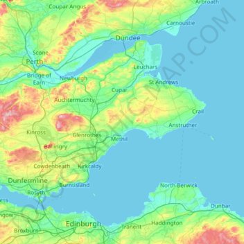
Name: Fife topographic map, elevation, terrain.

Location: Fife, Scotland, United Kingdom (56.00568 -3.73992 56.45350 -2.54424)

Average elevation: 67 m

Minimum elevation: -2 m

Maximum elevation: 510 m

Scotland trails, hiking, mountain biking, running and outdoor activities

Other topographic maps

Click on a map to view its topography, its elevation and its terrain.

Edinburgh

United Kingdom > Scotland > Edinburgh

Some have called Edinburgh the Athens of the North for a variety of reasons. The earliest comparison between the two cities showed that they had a similar topography, with the Castle Rock of Edinburgh performing a similar role to the Athenian Acropolis. Both of them had flatter, fertile agricultural land…

Average elevation: 104 m

Glasgow

United Kingdom > Scotland > Glasgow City

Glasgow itself was reputed to have been founded by the Christian missionary Saint Mungo in the 6th century. He established a church on the Molendinar Burn, where the present Glasgow Cathedral stands, and in the following years Glasgow became a religious centre. Glasgow grew over the following centuries. The…

Average elevation: 128 m

Callanish

United Kingdom > Scotland > Western Isles

Average elevation: 19 m

Ben Nevis

United Kingdom > Scotland > Highland

Ben Nevis has a highland (alpine) maritime (oceanic) polar climate (ET climate in the Köppen classification). Ben Nevis's elevation, maritime location and topography frequently lead to cool and cloudy weather conditions, which can pose a danger to ill-equipped walkers. According to the observations carried…

Average elevation: 912 m

Iona

United Kingdom > Scotland

Average elevation: 9 m

Oban

United Kingdom > Scotland > Argyll and Bute

Average elevation: 52 m

Insch

United Kingdom > Scotland > Aberdeenshire

Average elevation: 146 m

Auchleven

United Kingdom > Scotland > Aberdeenshire

Average elevation: 210 m

Scottish Highlands

United Kingdom > Scotland > Highland

The entire region was covered by ice sheets during the Pleistocene ice ages, save perhaps for a few nunataks. The complex geomorphology includes incised valleys and lochs carved by the action of mountain streams and ice, and a topography of irregularly distributed mountains whose summits have similar heights…

Average elevation: 907 m

Dundee

United Kingdom > Scotland > Dundee City

Dundee sits on the north bank of the Firth of Tay on the eastern, North Sea Coast of Scotland. The city lies 36.1 miles (58 km) NNE of Edinburgh and 360.6 miles (580 km) NNW of London. The built-up area occupies a roughly rectangular shape 8.3 miles (13 km) long by 2.5 miles (4 km) wide, aligned in an east to…

Average elevation: 82 m

Glen Lyon

United Kingdom > Scotland > Perth and Kinross

Average elevation: 461 m

Penicuik

United Kingdom > Scotland > Midlothian

Average elevation: 247 m

The Campsie Fells

United Kingdom > Scotland

Average elevation: 431 m

Hamilton

United Kingdom > Scotland > South Lanarkshire

Average elevation: 88 m

Ardersier

United Kingdom > Scotland > Highland

Ardersier /ˈɑːrdəsir/ (Scottish Gaelic: Àird nan Saor) is a small former fishing village in the Scottish Highlands on the Moray Firth near Fort George, between Inverness and Nairn. Its name may be an anglicisation of the Gaelic "Àird nan Saor", or "Headland of the joiners", one local legend being that…

Average elevation: 8 m

Denholm

United Kingdom > Scotland > Scottish Borders

In Main Street, stands The Text House, a category B listed building, erected about 1910 by John Haddon (1845–1924), a medical doctor and author of published works on public sanitation and dietetics. The 3-storey house is in the arts and craft style. One of the texts on the front elevation is a reminder to…

Average elevation: 128 m

Argyll and Bute

United Kingdom > Scotland

Average elevation: 683 m

Western Isles

United Kingdom > Scotland

Average elevation: 23 m

Ayrshire

United Kingdom > Scotland

Average elevation: 141 m

Inchmickery

United Kingdom > Scotland

Average elevation: 0 m

Ailsa Craig

United Kingdom > Scotland

In a small glen above Ailsa Castle, a small freshwater body known as the Garry Loch is located at an altitude of 247 m (810 ft), with a depth of at least 17 feet.

Average elevation: 14 m

Banffshire

United Kingdom > Scotland

Average elevation: 191 m

Stirlingshire

United Kingdom > Scotland

Average elevation: 222 m

Mull of Kintyre

United Kingdom > Scotland

Ailsa Craig and the County Antrim coast of Ulster and Rathlin Island are all clearly visible from the Mull. On clearer days it is also possible to make out Malin Head in Inishowen in County Donegal in the west of Ulster, and the Ayrshire coast on the other side of Ailsa Craig. Other islands in the Firth of…

Average elevation: 84 m

Glen Dochart

United Kingdom > Scotland

Average elevation: 469 m

Auchencorth Moss

United Kingdom > Scotland

Average elevation: 281 m

Denton Burn

United Kingdom > Scotland

Average elevation: 154 m

Taynish Island

United Kingdom > Scotland

Average elevation: 11 m

Devil's Beef Tub

United Kingdom > Scotland

Average elevation: 376 m

Grey Mare's Tail

United Kingdom > Scotland

Average elevation: 466 m

Meall Aundrary

United Kingdom > Scotland

Average elevation: 194 m

River Kerry

United Kingdom > Scotland

Average elevation: 118 m

Burian Hole

United Kingdom > Scotland

Average elevation: 36 m

Papa

United Kingdom > Scotland

Average elevation: 2 m

Sgùrr na Stri

United Kingdom > Scotland

Average elevation: 92 m

Braid Hill

United Kingdom > Scotland

Average elevation: 353 m

Loch Urigill

United Kingdom > Scotland

Average elevation: 172 m

Buachaille Etive Mor

United Kingdom > Scotland

Average elevation: 585 m

Highland

United Kingdom > Scotland

Average elevation: 402 m

Glen Croe

United Kingdom > Scotland

Average elevation: 355 m

Inverness-shire

United Kingdom > Scotland

Average elevation: 333 m

Cumbernauld

United Kingdom > Scotland > North Lanarkshire

Cumbernauld's name probably comes from the Gaelic comar nan allt, meaning "meeting of the burns or streams". There are differing views as to the etymology of this. One theory is that from its high point in the Central Belt, its streams flow both west to the River Clyde and east to the Firth of Forth so…

Average elevation: 113 m

Barrnacarry Bay

United Kingdom > Scotland

Average elevation: 32 m

Snap

United Kingdom > Scotland

Average elevation: 3 m

Lanarkshire

United Kingdom > Scotland

Average elevation: 183 m

Rubha nam Bùthan

United Kingdom > Scotland

Average elevation: 15 m

The Minch

United Kingdom > Scotland

Average elevation: 63 m

Firth of Clyde

United Kingdom > Scotland

Average elevation: 0 m

St Magnus' Bay

United Kingdom > Scotland

Average elevation: 6 m

Aberdeen

United Kingdom > Scotland > Aberdeen

Two weather stations collect climate data for the area, Aberdeen/Dyce Airport, and Craibstone. Both are about 4 1⁄2 miles (7 km) to the north west of the city centre, and given that they are in close proximity to each other, exhibit very similar climatic regimes. Dyce tends to have marginally warmer daytime…

Average elevation: 52 m

Inverness

United Kingdom > Scotland > Highland

Average elevation: 163 m

Kilmarnock

United Kingdom > Scotland > East Ayrshire

Average elevation: 56 m

Musselburgh

United Kingdom > Scotland > East Lothian

Average elevation: 32 m

Dunkeld

United Kingdom > Scotland > Perth and Kinross

Average elevation: 190 m

Winchburgh

United Kingdom > Scotland > West Lothian

Average elevation: 74 m

Polbeth

United Kingdom > Scotland > West Lothian

Average elevation: 166 m

Scapa Flow

United Kingdom > Scotland > Orkney Islands

Average elevation: 14 m

Glencoe

United Kingdom > Scotland > Highland

Average elevation: 114 m

St Andrews

United Kingdom > Scotland > Fife

Average elevation: 38 m

Fort William

United Kingdom > Scotland > Highland

Fort William has an oceanic climate (Cfb) with moderate, but generally cool, temperatures and abundant precipitation. In the towns immediate vicinity, there are significant variations in elevation, which leads to some uninhabited areas near the town having a subpolar oceanic climate (Cfc), or, at the absolute…

Average elevation: 122 m

Shotts

United Kingdom > Scotland > North Lanarkshire

Average elevation: 231 m

High Valleyfield

United Kingdom > Scotland > Fife

Average elevation: 33 m

Coaltown of Balgonie

United Kingdom > Scotland > Fife

Average elevation: 61 m

Ben More

United Kingdom > Scotland > Argyll and Bute

Ben More (Scottish Gaelic: Beinn Mhòr, meaning "great mountain") is the highest mountain and only Munro (mountains in Scotland that reach an elevation of at least 3,000 feet or 914.4 metres) on the Isle of Mull, Scotland. It is also the highest peak in the Scottish isles – and the only Munro – apart from…

Average elevation: 574 m

Urquhart

United Kingdom > Scotland > Moray

Average elevation: 32 m

Fyvie

United Kingdom > Scotland > Aberdeenshire

Average elevation: 96 m

Ben Lawers

United Kingdom > Scotland > Perth and Kinross

Due to its high elevation and underlying geology, Ben Lawers is home to an exceptionally rich selection of arctic-alpine plant species and habitats. Since 1964, it has been designated as a National Nature Reserve (NNR).

Average elevation: 849 m

Balmaha

United Kingdom > Scotland > Stirling

Average elevation: 50 m

Càrn Eige

United Kingdom > Scotland > Highland

Carn Eighe (Scottish Gaelic: Càrn Èite) is a mountain in the Northwest Highlands of Scotland. Rising to 1,183 metres (3,881 ft) above sea level, it is the highest mountain in Scotland north of the Great Glen, the twelfth-highest in the British Isles, and, in terms of relative height (topographic prominence),…

Average elevation: 867 m

Glen Coe

United Kingdom > Scotland > Highland > Glencoe

Habitats within Glen Coe include birch woodland, moorland and peatbogs. The upland parts of the glen are one of the best habitats for alpine and sub-alpine plants in Lochaber, due to the underlying geology and range of altitude. Typical plants found on the highest slopes of the glen include lady's mantle,…

Average elevation: 415 m

Falkirk

United Kingdom > Scotland > Falkirk

Falkirk is located in an area of undulating topography between the Slamannan Plateau and the upper reaches of the Firth of Forth. The area to the north of Falkirk is part of the floodplain of the River Carron. Two tributaries of the River Carron - the East Burn and the West Burn flow through the town and form…

Average elevation: 69 m

Stirling

United Kingdom > Scotland > Stirling

Average elevation: 161 m

Jedburgh

United Kingdom > Scotland > Scottish Borders

Average elevation: 151 m

Brechin

United Kingdom > Scotland > Angus

Average elevation: 71 m

Dunfermline

United Kingdom > Scotland > Fife > Dunfermline

Average elevation: 80 m

Aberlour

United Kingdom > Scotland > Moray

According to the 1846 A Topographical Dictionary of Scotland, "This parish, formerly called Skirdustan, signifying, in the Gaelic tongue, 'the division of Dustan', its tutelary saint, derived its present name from its situation at the mouth of a noisy burn, which discharges itself into the river Spey."

Average elevation: 160 m

Inverurie

United Kingdom > Scotland > Aberdeenshire

Average elevation: 102 m

Huntly

United Kingdom > Scotland > Aberdeenshire

Average elevation: 171 m

Banchory

United Kingdom > Scotland > Aberdeenshire

Average elevation: 117 m

Stonehaven

United Kingdom > Scotland > Aberdeenshire

Average elevation: 57 m

Ballater

United Kingdom > Scotland > Aberdeenshire

Ballater (/ˈbælətər/, Scottish Gaelic: Bealadair) is a village in Aberdeenshire, Scotland, on the River Dee, immediately east of the Cairngorm Mountains. Situated at an elevation of 213 metres (699 feet), Ballater is a centre for hikers and known for its spring water, once said to cure scrofula. It is home…

Average elevation: 360 m

Helensburgh

United Kingdom > Scotland > Argyll and Bute

Average elevation: 63 m

Alloa

United Kingdom > Scotland > Clackmannanshire

Average elevation: 22 m

Annan

United Kingdom > Scotland > Dumfries and Galloway

Average elevation: 25 m

Moffat

United Kingdom > Scotland > Dumfries and Galloway

Average elevation: 225 m

Dunbar

United Kingdom > Scotland > East Lothian

Average elevation: 24 m

Gear up for your next adventure:

🥾Hiking Boots - Waterproof and durable boots for long-distance hiking in the UK
🚲Cycling GPS Computers - Track elevation and topographic routes on two wheels
🥾Hiking Boot Waterproofing Wax - Maintain the lifespan of your leather trekking boots
🔋Solar Chargers - Eco-friendly charging solutions for outdoor use
🎒Replacement Sternum Straps - Repair parts for hiking rucksacks

As an Amazon Associate, this site earns from qualifying purchases at no extra cost to you.