
Rosendal topographic map
Interactive map
Click on the map to display elevation.
About this map
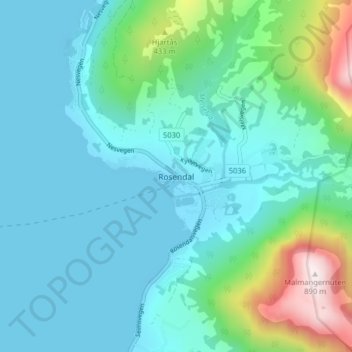
Name: Rosendal topographic map, elevation, terrain.
Location: Rosendal, Kvinnherad, Vestland, 5470, Norway (59.96698 5.98680 60.00698 6.02680)
Average elevation: 159 m
Minimum elevation: -13 m
Maximum elevation: 883 m
Other topographic maps
Click on a map to view its topography, its elevation and its terrain.
Kinn
Norway > Vestland > Rognaldsvåg
Kinn, Rognaldsvåg, Kinn, Vestland, 6912, Norway
Average elevation: 23 m