
Sungai Kemaman topographic map
Interactive map
Click on the map to display elevation.
About this map
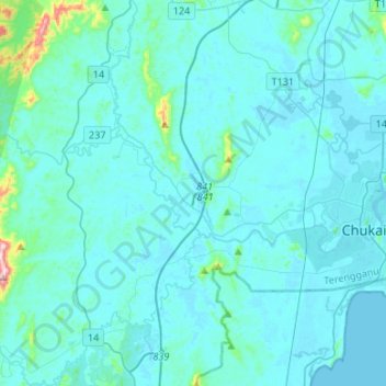
Name: Sungai Kemaman topographic map, elevation, terrain.
Location: Sungai Kemaman, Kemaman District, Terengganu, 24000, Malaysia (4.20329 103.18198 4.28506 103.44888)
Average elevation: 31 m
Minimum elevation: -1 m
Maximum elevation: 473 m
Other topographic maps
Click on a map to view its topography, its elevation and its terrain.
Bukit Pelanduk
Malaysia > Terengganu > Kemaman District > Kampung Teluk Kalong
Average elevation: 19 m
Sungai Kandang Rusa
Malaysia > Terengganu > Kemaman District > Kampung Semayor
Average elevation: 32 m