Geolocate

River Spey topographic map

Interactive map

Click on the map to display elevation.

About this map

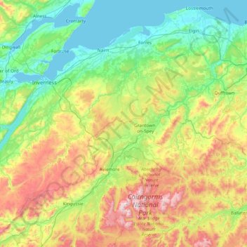
Name: River Spey topographic map, elevation, terrain.

Location: River Spey, Scotland, United Kingdom (57.00722 -4.59740 57.67703 -3.09358)

Average elevation: 336 m

Minimum elevation: 0 m

Maximum elevation: 1,303 m

Scotland trails, hiking, mountain biking, running and outdoor activities

Other topographic maps

Click on a map to view its topography, its elevation and its terrain.

Edinburgh

United Kingdom > Scotland > Edinburgh

Some have called Edinburgh the Athens of the North for a variety of reasons. The earliest comparison between the two cities showed that they had a similar topography, with the Castle Rock of Edinburgh performing a similar role to the Athenian Acropolis. Both of them had flatter, fertile agricultural land…

Average elevation: 104 m

Glasgow

United Kingdom > Scotland > Glasgow City

Glasgow itself was reputed to have been founded by the Christian missionary Saint Mungo in the 6th century. He established a church on the Molendinar Burn, where the present Glasgow Cathedral stands, and in the following years Glasgow became a religious centre. Glasgow grew over the following centuries. The…

Average elevation: 128 m

Corry Bruoch Beg

United Kingdom > Scotland > Highland

Average elevation: 335 m

Aberdeen

United Kingdom > Scotland > Aberdeen

Two weather stations collect climate data for the area, Aberdeen/Dyce Airport, and Craibstone. Both are about 4 1⁄2 miles (7 km) to the north west of the city centre, and given that they are in close proximity to each other, exhibit very similar climatic regimes. Dyce tends to have marginally warmer daytime…

Average elevation: 52 m

Ben Nevis

United Kingdom > Scotland > Highland

Ben Nevis has a highland (alpine) maritime (oceanic) polar climate (ET climate in the Köppen classification). Ben Nevis's elevation, maritime location and topography frequently lead to cool and cloudy weather conditions, which can pose a danger to ill-equipped walkers. According to the observations carried…

Average elevation: 912 m

Kilbride

United Kingdom > Scotland > Highland

Average elevation: 116 m

Dunfermline

United Kingdom > Scotland > Fife > Dunfermline

Average elevation: 80 m

Alford

United Kingdom > Scotland > Aberdeenshire

Average elevation: 189 m

Inverness

United Kingdom > Scotland > Highland

Average elevation: 163 m

Abbey St. Bathans

United Kingdom > Scotland > Scottish Borders

Abbey St Bathans (Scottish Gaelic: Abaid Bhaoithin) is a parish in the Lammermuir district of Berwickshire, in the eastern part of the Scottish Borders. Unique in its topography, it is situated in a long winding steep wooded valley that follows the Whiteadder Water. The parish had a population of 106 at the…

Average elevation: 212 m

Piperdam

United Kingdom > Scotland > Angus

Average elevation: 179 m

Ayrshire

United Kingdom > Scotland

Average elevation: 141 m

Cathkin Park

United Kingdom > Scotland > Glasgow City > Glasgow

Average elevation: 26 m

Oban

United Kingdom > Scotland > Argyll and Bute

Average elevation: 52 m

Bridge of Allan

United Kingdom > Scotland > Stirling

Average elevation: 80 m

Dunblane

United Kingdom > Scotland > Stirling

Average elevation: 117 m

Dundee

United Kingdom > Scotland > Dundee City

Dundee sits on the north bank of the Firth of Tay on the eastern, North Sea Coast of Scotland. The city lies 36.1 miles (58 km) NNE of Edinburgh and 360.6 miles (580 km) NNW of London. The built-up area occupies a roughly rectangular shape 8.3 miles (13 km) long by 2.5 miles (4 km) wide, aligned in an east to…

Average elevation: 82 m

Daviot

United Kingdom > Scotland > Aberdeenshire

Average elevation: 102 m

Bankfoot

United Kingdom > Scotland > Perth and Kinross

Average elevation: 90 m

Aviemore

United Kingdom > Scotland > Highland

Average elevation: 331 m

St Andrews

United Kingdom > Scotland > Fife

Average elevation: 38 m

Fort William

United Kingdom > Scotland > Highland

Fort William has an oceanic climate (Cfb) with moderate, but generally cool, temperatures and abundant precipitation. In the towns immediate vicinity, there are significant variations in elevation, which leads to some uninhabited areas near the town having a subpolar oceanic climate (Cfc), or, at the absolute…

Average elevation: 122 m

Thurso

United Kingdom > Scotland > Highland

Average elevation: 25 m

Struan

United Kingdom > Scotland > Perth and Kinross

Average elevation: 273 m

Sutherland

United Kingdom > Scotland

Average elevation: 109 m

Banffshire

United Kingdom > Scotland

Average elevation: 191 m

Portree

United Kingdom > Scotland > Highland

Average elevation: 121 m

Falkirk

United Kingdom > Scotland > Falkirk

Falkirk is located in an area of undulating topography between the Slamannan Plateau and the upper reaches of the Firth of Forth. The area to the north of Falkirk is part of the floodplain of the River Carron. Two tributaries of the River Carron - the East Burn and the West Burn flow through the town and form…

Average elevation: 69 m

Forres

United Kingdom > Scotland > Moray

Average elevation: 31 m

Glen Dye

United Kingdom > Scotland > Angus

Average elevation: 416 m

Aberlour

United Kingdom > Scotland > Moray

According to the 1846 A Topographical Dictionary of Scotland, "This parish, formerly called Skirdustan, signifying, in the Gaelic tongue, 'the division of Dustan', its tutelary saint, derived its present name from its situation at the mouth of a noisy burn, which discharges itself into the river Spey."

Average elevation: 160 m

Pitlochry

United Kingdom > Scotland > Perth and Kinross

Average elevation: 276 m

Cadham Village

United Kingdom > Scotland > Fife

Average elevation: 103 m

Loch Lubnaig

United Kingdom > Scotland > Stirling

Average elevation: 382 m

Cowie

United Kingdom > Scotland > Stirling

Average elevation: 30 m

Maryburgh

United Kingdom > Scotland > Highland

Average elevation: 56 m

Livingston

United Kingdom > Scotland > West Lothian

Average elevation: 158 m

Glen Nevis

United Kingdom > Scotland > Highland > Achriabhach

Average elevation: 265 m

Pitlochry

United Kingdom > Scotland > Perth and Kinross

Average elevation: 276 m

Torridon

United Kingdom > Scotland > Highland

Average elevation: 236 m

Grampian Mountains

United Kingdom > Scotland > Highland

Average elevation: 775 m

Dreghorn

United Kingdom > Scotland > North Ayrshire

Average elevation: 19 m

Aultbea

United Kingdom > Scotland > Highland

Average elevation: 44 m

Glen Nevis

United Kingdom > Scotland > Highland > Achriabhach

Average elevation: 265 m

Skara Brae

United Kingdom > Scotland > Orkney Islands

Average elevation: 15 m

Muir of Ord

United Kingdom > Scotland > Highland

Average elevation: 70 m

Morvich

United Kingdom > Scotland > Highland

Average elevation: 100 m

New Deer

United Kingdom > Scotland > Aberdeenshire

Average elevation: 115 m

Daldowie

United Kingdom > Scotland > Glasgow City > Glasgow

Average elevation: 38 m

Loch Kemp

United Kingdom > Scotland > Highland

Average elevation: 181 m

Leanachan Forest

United Kingdom > Scotland > Highland > Torlundy

Average elevation: 100 m

Ardchyle

United Kingdom > Scotland > Stirling

Average elevation: 281 m

Staffa

United Kingdom > Scotland > Argyll and Bute

Average elevation: 0 m

Darnick

United Kingdom > Scotland > Scottish Borders

Average elevation: 160 m

Ardrossan

United Kingdom > Scotland > North Ayrshire

Average elevation: 21 m

Glen Nevis

United Kingdom > Scotland > Highland > Achriabhach

Average elevation: 265 m

Paisley

United Kingdom > Scotland > Renfrewshire

Average elevation: 33 m

Lingay

United Kingdom > Scotland > Western Isles

Average elevation: 1 m

Doghill

United Kingdom > Scotland > Scottish Borders > Kelso > Spylaw

Average elevation: 87 m

Glencoe

United Kingdom > Scotland > Highland

Average elevation: 114 m

Ben Stack

United Kingdom > Scotland > Highland

Average elevation: 274 m

Dundonald

United Kingdom > Scotland > South Ayrshire

Average elevation: 44 m

Bunloit

United Kingdom > Scotland > Highland

Average elevation: 150 m

Old Man of Storr

United Kingdom > Scotland > Highland

Average elevation: 354 m

Airdrie

United Kingdom > Scotland > North Lanarkshire

Airdrie's name first appeared in the Register of the Great Seal of Scotland (Registrum Magni Sigilii Regum Scotorum) in 1373 as Ardre. By 1546 it had become Ardry and by 1587 it was known as Ardrie. In 1630 it finally appeared in the Register as Airdrie. Given the topography of the area, the most likely…

Average elevation: 136 m

Longcroft

United Kingdom > Scotland > Falkirk

Average elevation: 83 m

Cleish

United Kingdom > Scotland > Perth and Kinross

Average elevation: 178 m

Glenlivet

United Kingdom > Scotland > Moray

Average elevation: 280 m

Cairn Toul

United Kingdom > Scotland > Aberdeenshire

Average elevation: 922 m

Linlithgow

United Kingdom > Scotland > West Lothian

Average elevation: 95 m

Peebles

United Kingdom > Scotland > Scottish Borders

Average elevation: 275 m

New Deer

United Kingdom > Scotland > Aberdeenshire

Average elevation: 115 m

Aonach Mòr

United Kingdom > Scotland > Highland

Aonach Mòr is a mountain in the Scottish Highlands. It is located about two miles (three kilometres) northeast of Ben Nevis on the south side of Glen Spean, near Fort William. The mountain has a summit elevation of 4,006 ft (1,221 m) and is classified as a Munro.

Average elevation: 898 m

Aonach Beag

United Kingdom > Scotland > Highland

Aonach Beag is linked to its close neighbour to the north, Aonach Mòr, by a high saddle or bealach. The name Aonach Beag (small ridge) might imply that this mountain is smaller than Aonach Mòr (big ridge). However, Aonach Beag is higher; the names refer to the relative bulk of the two mountains rather than…

Average elevation: 825 m

Gartymore

United Kingdom > Scotland > Highland > Portgower

Average elevation: 94 m

Broughton

United Kingdom > Scotland > Scottish Borders

Average elevation: 268 m

Gowkshill

United Kingdom > Scotland > Midlothian > Newtongrange

Average elevation: 145 m

Huntly

United Kingdom > Scotland > Aberdeenshire

Average elevation: 171 m

Cac Càrn Mòr

United Kingdom > Scotland > Aberdeenshire

Average elevation: 937 m

Glen Etive

United Kingdom > Scotland > Highland

Average elevation: 477 m

Gifford

United Kingdom > Scotland > East Lothian

Average elevation: 142 m

Hilltown

United Kingdom > Scotland > Midlothian > Danderhall

Average elevation: 58 m

Ballingry

United Kingdom > Scotland > Fife

Average elevation: 121 m

Insch

United Kingdom > Scotland > Aberdeenshire

Average elevation: 146 m

Crail

United Kingdom > Scotland > Fife

Average elevation: 21 m

Bass Rock

United Kingdom > Scotland > East Lothian

Average elevation: 0 m