
Puerto Rico topographic map
Interactive map
Click on the map to display elevation.
Puerto Rico
The island is mostly mountainous with large coastal areas in the north and south. The main mountain range is called "La Cordillera Central" (The Central Range). The highest elevation in Puerto Rico, Cerro de Punta 4,390 feet (1,340 m), is located in this range.
About this map
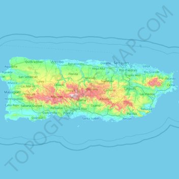
Name: Puerto Rico topographic map, elevation, terrain.
Location: Puerto Rico, United States (17.92687 -67.27149 18.51598 -65.58975)
Average elevation: 65 m
Minimum elevation: -2 m
Maximum elevation: 1,265 m
Other topographic maps
Click on a map to view its topography, its elevation and its terrain.
Gozalandia Waterfall
United States > Puerto Rico > San Sebastián > San Sebastián
Average elevation: 176 m
Mayagüez
United States > Puerto Rico > Mayagüez
Mayagüez has a tropical monsoon climate (Köppen climate classification Am). The city has the most extreme weather of the island. The high frequency of severe storms in the summer can produce strong winds, floods, waterspouts, and sometimes hail and even tornadoes. The average annual temperature is 75 °F (24…
Average elevation: 93 m
Cerro de Punta
United States > Puerto Rico > Ponce
The mountain is part of the Cordillera Central and is located on the border between the municipalities of Jayuya and Ponce. The access road to the point closest to the highest elevation is from the municipality of Jayuya. It is part of the Toro Negro Forest Reserve, and it has been described as "an alpine…
Average elevation: 1,021 m
Cayey
United States > Puerto Rico > Cayey
Cayey's climate is humid, rainy and mild compared to lower-elevation areas of the island, the area of the town is nearly 1,500 feet (460 m) high, so the climate is subtropical high. In summer average high Temperatures are around 82 °F to 88 °F and 70 °F to 78 °F in winter, and low around 68 °F to 72 °F…
Average elevation: 489 m
Culebra
United States > Puerto Rico > Culebra > Culebra
Culebra is characterized by an irregular topography resulting in a long intricate shoreline. The island is approximately 7 by 5 miles (11 by 8 km). The coast is marked by cliffs, sandy coral beaches and mangrove forests. Inland, the tallest point on the island is Mount Resaca, with an elevation of 636 ft…
Average elevation: 16 m
Villalba
United States > Puerto Rico > Villalba > Villalba
Villalba is located in the central region of Puerto Rico, on a valley in the Cordillera Central. The highest point in the municipality is Cerro El Bolo at 3,526 feet (1,075 m) of elevation.
Average elevation: 406 m