
Sikkim topographic map
Interactive map
Click on the map to display elevation.
About this map
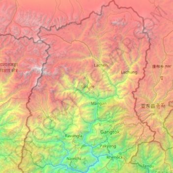
Name: Sikkim topographic map, elevation, terrain.
Location: Sikkim, India (27.07940 88.01203 28.12264 88.92137)
Average elevation: 3,786 m
Minimum elevation: 264 m
Maximum elevation: 8,447 m
Situated in the Himalayan mountains, the state of Sikkim is characterised by mountainous terrain. Almost the entire state is hilly, with an elevation ranging from 280 metres (920 ft) in the south at the border with West Bengal to 8,586 metres (28,169 ft) in northern peaks near Nepal and Tibet. The summit of Kangchenjunga, the world's third-highest peak, is the state's highest point, situated on the border between Sikkim and Nepal. For the most part, the land is unfit for agriculture because of the rocky, precipitous slopes. However, some hill slopes have been converted into terrace farms.
Other topographic maps
Click on a map to view its topography, its elevation and its terrain.
Bengaluru
India > Karnataka > Bangalore North
Bengaluru, Bangalore North, Bengaluru Urban District, Karnataka, India
Average elevation: 881 m
Chennai
India > Tamil Nadu > Chennai
Chennai, Chennai District, Tamil Nadu, India
Average elevation: 8 m
Srinagar
India > Jammu and Kashmir > Srinagar (South)
Srinagar, Srinagar (South), Srinagar District, Jammu and Kashmir, 190001, India
Average elevation: 1,805 m
3d
India > Rajasthan > Ganganagar Tehsil > 1 LNP
3d, 1 LNP, Ganganagar Tehsil, Sri Ganganagar District, Rajasthan, India
Average elevation: 178 m
Pune
India > Maharashtra > Pune City > Pune
Pune, Pune City, Pune District, Maharashtra, 411001, India
Average elevation: 641 m
Kandonthar
India > Kerala > Payyannur Taluk
Kandonthar, Payyannur Taluk, Kannur District, Kerala, 670501, India
Average elevation: 25 m
Bachupally mandal
Bachupally mandal, Medchal–Malkajgiri District, Telangana, 500090, India
Average elevation: 593 m
Coimbatore
India > Tamil Nadu > Coimbatore North
Coimbatore, Coimbatore North, Coimbatore District, Tamil Nadu, 641001, India
Average elevation: 452 m
Kanthan
India > Jammu and Kashmir > Gool-Gulabgarh
Kanthan, Gool-Gulabgarh, Reasi District, Jammu and Kashmir, India
Average elevation: 820 m
Pilathara
India > Kerala > Payyannur Taluk
Pilathara, Kalliasseri Block, Payyannur Taluk, Kannur District, Kerala, 670504, India
Average elevation: 15 m
Bhubaneshwar
India > Odisha > Bhubaneswar (M.Corp.)
Bhubaneshwar, Bhubaneswar Municipal Corporation, Bhubaneswar (M.Corp.), Khordha District, Odisha, 751001, India
Average elevation: 30 m
Jaipur
India > Rajasthan > Jaipur Tehsil
Jaipur, Jaipur Municipal Corporation, Jaipur Tehsil, Jaipur District, Rajasthan, 302001, India
Average elevation: 408 m
Dholka
India > Madhya Pradesh > Ratlam Tahsil
Dholka, Ratlam Tahsil, Ratlam District, Madhya Pradesh, India
Average elevation: 467 m
musi
India > Telangana > Balanagar mandal > Hyderabad
musi, Greater Hyderabad Municipal Corporation North Zone, Hyderabad, Balanagar mandal, Medchal–Malkajgiri District, Telangana, India
Average elevation: 524 m
Pernampattu
India > Tamil Nadu > Gudiyatham
Pernampattu, Gudiyatham, Vellore District, Tamil Nadu, 635810, India
Average elevation: 425 m
Pandarapuram
India > Tamil Nadu > Sathankulam
Pandarapuram, Sathankulam, Thoothukudi District, Tamil Nadu, 628704, India
Average elevation: 35 m
Marungapuri
India > Tamil Nadu > Manapparai
Marungapuri, Manapparai, Tiruchirappalli District, Tamil Nadu, India
Average elevation: 249 m
Manapparai
India > Tamil Nadu > Manapparai
Manapparai, Tiruchirappalli District, Tamil Nadu, 621306, India
Average elevation: 161 m
Tehri-Garhwal
Tehri-Garhwal, Tehri Garhwal District, Uttarakhand, 249125, India
Average elevation: 2,339 m
Patna
India > Bihar > Patna Rural
Patna, Patna Rural, Patna District, Bihar, 800001, India
Average elevation: 51 m
Kolkata
Kolkata, Kolkata District, West Bengal, 700073, India
Average elevation: 5 m
Harapanahalli
India > Karnataka > Harapanahalli taluku
Harapanahalli, Harapanahalli taluku, Vijayanagara District, Karnataka, 583131, India
Average elevation: 626 m