
Köprübaşı topographic map
Interactive map
Click on the map to display elevation.
Köprübaşı
Köprübaşı is a municipality and district of Manisa Province, Turkey. Its area is 447 km2, and its population is 12,730 (2022). The town lies at an elevation of 252 m (827 ft). At the 2013 reorganisation, it absorbed part of the district of Demirci.
About this map
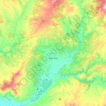
Name: Köprübaşı topographic map, elevation, terrain.
Location: Köprübaşı, Manisa, Aegean Region, 45930, Turkey (38.64495 28.17620 38.88141 28.59897)
Average elevation: 538 m
Minimum elevation: 153 m
Maximum elevation: 1,353 m
Other topographic maps
Click on a map to view its topography, its elevation and its terrain.
Cappadocia
Turkey > Central Anatolia Region > Göreme
The area was featured in several films due to its topography. The 1983 Italian/French/Turkish film Yor, the Hunter from the Future was filmed in Cappadocia. The region was used for the 1989 science fiction film Slipstream to depict a cult of wind worshippers. In 2010 and early 2011, the film Ghost Rider:…
Average elevation: 1,144 m