
Palakkad district topographic map
Interactive map
Click on the map to display elevation.
About this map
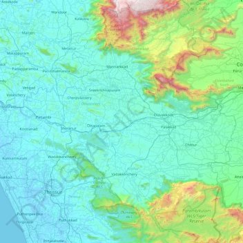
Name: Palakkad district topographic map, elevation, terrain.
Location: Palakkad district, Kerala, India (10.33493 76.02672 11.23906 76.90722)
Average elevation: 305 m
Minimum elevation: -5 m
Maximum elevation: 2,430 m
Palakkad (Malayalam: [pɐːlɐkːɐːɖɨ̆] (listen)) is one of the 14 districts in the Indian state of Kerala. It was carved out from the southeastern region of the former Malabar District on 1 January 1957. It is located at the centre of Kerala. It is the largest district in the state since 2006. The city of Palakkad is the district headquarters. Palakkad is bordered on the northwest by the Malappuram district, on the southwest by the Thrissur district, on the northeast by Nilgiris district, and on the east by Coimbatore district of Tamil Nadu. The district is nicknamed "The granary of Kerala". Palakkad is the gateway to Kerala due to the presence of the Palakkad Gap, in the Western Ghats. The 2,383 m high Anginda peak, which is situated in the border of Palakkad district, Nilgiris district, and Malappuram district, in Silent Valley National Park, is the highest point of elevation in Palakkad district. Palakkad city is located just 50 km away from Coimbatore, a major city in Tamil Nadu state.
Other topographic maps
Click on a map to view its topography, its elevation and its terrain.
Kandonthar
India > Kerala > Payyannur Taluk
Kandonthar, Payyannur Taluk, Kannur District, Kerala, 670501, India
Average elevation: 25 m
Pilathara
India > Kerala > Payyannur Taluk
Pilathara, Kalliasseri Block, Payyannur Taluk, Kannur District, Kerala, 670504, India
Average elevation: 15 m
Periyar River
India > Kerala > Paravur > Edayar
Periyar River, Njaarakkaattu, Edayar, Paravur, Ernakulam District, Kerala, India
Average elevation: 8 m
Western Ghats
Western Ghats, Idukki, Kerala, 685614, India
Average elevation: 2,225 m
Thiruvananthapuram
India > Kerala > Thiruvananthapuram
Thiruvananthapuram, Thiruvananthapuram District, Kerala, 695001, India
Average elevation: 33 m
Kallooppara
India > Kerala > Mallappally
Kallooppara, Mallappally, Pathanamthitta District, Kerala, 689583, India
Average elevation: 19 m
Triprayar Beach
India > Kerala > Chavakkad > Thriprayar
Triprayar Beach, Thriprayar, Chavakkad, Thrissur District, Kerala, India
Average elevation: 4 m
Vagamon Lake
India > Kerala > Peerumade > Vagamon
Vagamon Lake, Vagamon, Peerumade, Idukki District, Kerala, India
Average elevation: 976 m
Thodupuzha
India > Kerala > Thodupuzha
Thodupuzha, Idukki District, Kerala, 685584, India
Average elevation: 53 m
Suryanelli
India > Kerala > Udumbanchola
Suryanelli, Udumbanchola, Idukki District, Kerala, India
Average elevation: 1,553 m
Kottakombur
Kottakombur, Devikulam, Idukki District, Kerala, India
Average elevation: 1,919 m
Irinjalakuda
India > Kerala > Mukundapuram
Irinjalakuda, Mukundapuram, Thrissur District, Kerala, 680100, India
Average elevation: 7 m
chullimanoor
India > Kerala > Nedumangad
chullimanoor, Nedumangad, Thiruvananthapuram District, Kerala, 695541, India
Average elevation: 94 m
Santhanpara
India > Kerala > Udumbanchola > Choondal
Santhanpara, Choondal, Udumbanchola, Idukki District, Kerala, India
Average elevation: 1,111 m
Poopara
India > Kerala > Udumbanchola
Poopara, Udumbanchola, Idukki District, Kerala, 685619, India
Average elevation: 1,140 m
Puthencruz
India > Kerala > Kunnathunad
Puthencruz, Kunnathunad, Ernakulam District, Kerala, 682308, India
Average elevation: 25 m
Kallara
India > Kerala > Nedumangad
Kallara, Nedumangad, Thiruvananthapuram District, Kerala, 695610, India
Average elevation: 110 m
sree krishna swami temple pond
India > Kerala > Karthikappally > Kayamkulam
sree krishna swami temple pond, Puthuvel Harijan Colony, Kayamkulam, Karthikappally, Alappuzha District, Kerala, India
Average elevation: 9 m
Murikkumthotti
India > Kerala > Udumbanchola
Murikkumthotti, Udumbanchola, Idukki District, Kerala, 685619, India
Average elevation: 1,099 m
Cheruthapullur Kulam
Cheruthapullur Kulam, Alathur, Palakkad District, Kerala, India
Average elevation: 90 m
kanthaloor pond 2
India > Kerala > Ottappalam > Vellinezhi
kanthaloor pond 2, Vellinezhi, Ottappalam, Palakkad District, Kerala, India
Average elevation: 58 m
Mathoor
India > Kerala > Alathur > Kuzhalmannam
Mathoor, Kuzhalmannam, Alathur, Palakkad District, Kerala, 678571, India
Average elevation: 75 m
Parumala
India > Kerala > Thiruvalla
Parumala, Thiruvalla, Pathanamthitta District, Kerala, 689626, India
Average elevation: 6 m
Nellor Pond
India > Kerala > Chengannur
Nellor Pond, Chengannur, Alappuzha District, Kerala, India
Average elevation: 6 m
Rajakkad
India > Kerala > Udumbanchola > Kalungu City
Rajakkad, Kalungu City, Udumbanchola, Idukki District, Kerala, 685566, India
Average elevation: 855 m
Palvelicham
India > Kerala > Mananthavady
Palvelicham, Mananthavady, Wayanad District, Kerala, India
Average elevation: 735 m
Adivaram
India > Kerala > Thamarassery
Adivaram, Thamarassery, Kozhikode District, Kerala, 673586, India
Average elevation: 301 m
Velliangiri
Velliangiri, Mannarkad, Palakkad District, Kerala, India
Average elevation: 1,307 m
Karumalloor
India > Kerala > Paravur > Manjaly
Karumalloor, Manjaly, Paravur, Ernakulam District, Kerala, India
Average elevation: 7 m
Vellarikundu
India > Kerala > Vellarikkundu > Kadumeni
Vellarikundu, Kadumeni, Vellarikkundu, Kasaragod District, Kerala, India
Average elevation: 85 m
Rajakumari
India > Kerala > Udumbanchola
Rajakumari, Udumbanchola, Idukki District, Kerala, 685619, India
Average elevation: 1,001 m
Charakadvu
India > Kerala > Hosdurg > Karuvakkode
Charakadvu, Karuvakkode, Hosdurg, Kasaragod District, Kerala, 671316, India
Average elevation: 25 m
Elanthoor
India > Kerala > Kozhencherry
Elanthoor, Kozhencherry, Pathanamthitta District, Kerala, 689643, India
Average elevation: 38 m
Vavadukkam
India > Kerala > Kasaragod > Bedadka
Vavadukkam, Bedadka, Kasaragod, Kasaragod District, Kerala, India
Average elevation: 133 m
Pallikkara
India > Kerala > Kunnathunad
Pallikkara, Kunnathunad, Ernakulam District, Kerala, 683565, India
Average elevation: 12 m
Kottakkani
Kottakkani, Hosdurg, Kasaragod District, Kerala, 671316, India
Average elevation: 23 m
Kizhakkekallada
Kizhakkekallada, Kollam, Kollam District, Kerala, 691502, India
Average elevation: 10 m