
Kerkis topographic map
Interactive map
Click on the map to display elevation.
About this map
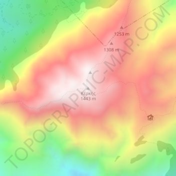
Name: Kerkis topographic map, elevation, terrain.
Average elevation: 1,011 m
Minimum elevation: 452 m
Maximum elevation: 1,430 m
Other topographic maps
Click on a map to view its topography, its elevation and its terrain.
Symi
Greece > Aegean > Rhodes Regional Unit > Emporios
Symi, Emporios, Municipality of Symi, Rhodes Regional Unit, South Aegean, Aegean, 856 00, Greece
Average elevation: 81 m
Santorini
Greece > Aegean > Thira Regional Unit > Thira Municipal Unit
Santorini, Thira Municipal Unit, Municipality of Thira, Thira Regional Unit, South Aegean, Aegean, Greece
Average elevation: 30 m
Hora
Greece > Aegean > Thira Regional Unit
Hora, Municipality of Anafi, Thira Regional Unit, South Aegean, Aegean, 840 09, Greece
Average elevation: 110 m
Municipality of Symi
Greece > Aegean > Rhodes Regional Unit
Municipality of Symi, Rhodes Regional Unit, South Aegean, Aegean, 856 00, Greece
Average elevation: 42 m
Samos
Greece > Aegean > Samos Regional Unit
Samos, Samos Regional Unit, Northern Aegean, Aegean, Greece
Average elevation: 78 m
Anafi
Greece > Aegean > Thira Regional Unit > Chora, Anafi
Anafi, Chora, Anafi, Municipality of Anafi, Thira Regional Unit, South Aegean, Aegean, 840 09, Greece
Average elevation: 46 m
Kos
Greece > Aegean > Kos Regional Unit
Kos, Municipality of Kos, Kos Regional Unit, South Aegean, Aegean, 853 00, Greece
Average elevation: 32 m
Mykonos
Greece > Aegean > Mykonos Regional Unit > Agios Stefanos
Mykonos, Agios Stefanos, Municipality of Mykonos, Mykonos Regional Unit, South Aegean, Aegean, 846 00, Greece
Average elevation: 38 m
Naxos
Greece > Aegean > Naxos Regional Unit
Naxos, Naxos Regional Unit, South Aegean, Aegean, Greece
Average elevation: 112 m
Kotsinas Beach
Greece > Aegean > Lemnos Regional Unit > Κότσινας
Kotsinas Beach, Κότσινας, Lemnos Municipality, Lemnos Regional Unit, Northern Aegean, Aegean, 814 01, Greece
Average elevation: 15 m
Paros
Greece > Aegean > Paros Regional Unit
Paros, Paros Regional Unit, South Aegean, Aegean, Greece
Average elevation: 69 m
Klima
Greece > Aegean > Milos Regional Unit
Klima, Municipality of Kimolos, Milos Regional Unit, South Aegean, Aegean, Greece
Average elevation: 13 m
Taxiarches
Greece > Aegean > Lesbos Regional Unit > Mytilene Municipal Unit
Taxiarches, Mytilene Municipal Unit, Municipality of Mytilene, Lesbos Regional Unit, Northern Aegean, Aegean, 811 00, Greece
Average elevation: 149 m
Καμάρα
Greece > Aegean > Syros Regional Unit > Ano Syros
Καμάρα, Ano Syros, Municipality of Syros and Ermoupoli, Syros Regional Unit, South Aegean, Aegean, 841 00, Greece
Average elevation: 119 m
Milos
Greece > Aegean > Milos Regional Unit
Milos, Milos Regional Unit, South Aegean, Aegean, Greece
Average elevation: 24 m
Βουρκάρι
Greece > Aegean > Kea-Kythnos Regional Unit > Korissia
Βουρκάρι, Korissia, Kea Municipality, Kea-Kythnos Regional Unit, South Aegean, Aegean, 840 02, Greece
Average elevation: 63 m
Oia
Greece > Aegean > Thira Regional Unit > Ia Municipal Unit
Oia, Ia Municipal Unit, Municipality of Thira, Thira Regional Unit, South Aegean, Aegean, 847 02, Greece
Average elevation: 20 m
Mytilene Municipal Unit
Greece > Aegean > Lesbos Regional Unit
Mytilene Municipal Unit, Municipality of Mytilene, Lesbos Regional Unit, Northern Aegean, Aegean, Greece
Average elevation: 67 m
Σαρδές
Greece > Aegean > Lemnos Regional Unit
Σαρδές, Lemnos Municipality, Lemnos Regional Unit, Northern Aegean, Aegean, 814 00, Greece
Average elevation: 191 m
Kastri
Greece > Aegean > Kos Regional Unit > Kefalos
Kastri, Kefalos, Municipality of Kos, Kos Regional Unit, South Aegean, Aegean, 853 01, Greece
Average elevation: 16 m
Municipality of Mykonos
Greece > Aegean > Mykonos Regional Unit
Municipality of Mykonos, Mykonos Regional Unit, South Aegean, Aegean, Greece
Average elevation: 11 m
Kochylos
Greece > Aegean > Andros Regional Unit
Kochylos, Municipality of Andros, Andros Regional Unit, South Aegean, Aegean, 845 02, Greece
Average elevation: 296 m
Mykonos
Greece > Aegean > Mykonos Regional Unit
Mykonos, Municipality of Mykonos, Mykonos Regional Unit, South Aegean, Aegean, 846 00, Greece
Average elevation: 46 m
Municipal Unit of Rhodes
Greece > Aegean > Rhodes Regional Unit
Municipal Unit of Rhodes, Municipality of Rhodes, Rhodes Regional Unit, South Aegean, Aegean, Greece
Average elevation: 27 m
Fanes
Greece > Aegean > Rhodes Regional Unit
Fanes, Municipality of Rhodes, Rhodes Regional Unit, South Aegean, Aegean, 851 06, Greece
Average elevation: 46 m
Syros
Greece > Aegean > Syros Regional Unit > Mesaria
Syros, Mesaria, Municipality of Syros and Ermoupoli, Syros Regional Unit, South Aegean, Aegean, 841 00, Greece
Average elevation: 32 m
Amorgos
Greece > Aegean > Naxos Regional Unit
Amorgos, Naxos Regional Unit, South Aegean, Aegean, 840 08, Greece
Average elevation: 28 m
Lemnos
Greece > Aegean > Lemnos Regional Unit
Lemnos, Lemnos Regional Unit, Northern Aegean, Aegean, Greece
Average elevation: 27 m
Ermoupoli
Greece > Aegean > Syros Regional Unit
Ermoupoli, Municipality of Syros and Ermoupoli, Syros Regional Unit, South Aegean, Aegean, 841 00, Greece
Average elevation: 75 m
Karpathos
Greece > Aegean > Karpathos-Kasos Regional Unit
Karpathos, Karpathos-Kasos Regional Unit, South Aegean, Aegean, Greece
Average elevation: 37 m
Naxos
Greece > Aegean > Naxos Regional Unit
Naxos, Municipality of Naxos and the Lesser Cyclades, Naxos Regional Unit, South Aegean, Aegean, 843 00, Greece
Average elevation: 33 m
Chios
Greece > Aegean > Chios Regional Unit
Chios, Chios Municipality, Chios Regional Unit, Northern Aegean, Aegean, 821 31, Greece
Average elevation: 82 m
Antimilos
Greece > Aegean > Milos Regional Unit
Antimilos, Municipality of Milos, Milos Regional Unit, South Aegean, Aegean, Greece
Average elevation: 138 m
Kata beach
Greece > Aegean > Kos Regional Unit
Kata beach, Municipality of Kos, Kos Regional Unit, South Aegean, Aegean, Greece
Average elevation: 18 m
Malia
Greece > Aegean > Syros Regional Unit > Episkopio
Malia, Episkopio, Municipality of Syros and Ermoupoli, Syros Regional Unit, South Aegean, Aegean, 841 00, Greece
Average elevation: 95 m
Antiparos Municipality
Greece > Aegean > Paros Regional Unit
Antiparos Municipality, Paros Regional Unit, South Aegean, Aegean, Greece
Average elevation: 12 m
Myrina
Greece > Aegean > Lemnos Regional Unit
Myrina, Lemnos Municipality, Lemnos Regional Unit, Northern Aegean, Aegean, 814 00, Greece
Average elevation: 39 m
Serifos
Greece > Aegean > Milos Regional Unit > Livadi
Serifos, Livadi, Municipality of Serifos, Milos Regional Unit, South Aegean, Aegean, 840 05, Greece
Average elevation: 106 m
Rhodes
Greece > Aegean > Rhodes Regional Unit
Rhodes, Municipality of Rhodes, Rhodes Regional Unit, South Aegean, Aegean, 851 00, Greece
Average elevation: 29 m
Sifnos
Greece > Aegean > Milos Regional Unit > Platys Gialos
Sifnos, Platys Gialos, Municipality of Sifnos, Milos Regional Unit, South Aegean, Aegean, 840 03, Greece
Average elevation: 61 m
Folegandros
Greece > Aegean > Thira Regional Unit > Ano Meria
Folegandros, Ano Meria, Municipality of Folegandros, Thira Regional Unit, South Aegean, Aegean, 840 11, Greece
Average elevation: 38 m
Agathonisi
Greece > Aegean > Kalmynos Regional Unit > Megalo Chorio
Agathonisi, Megalo Chorio, Agathonisi Municipality, Kalmynos Regional Unit, South Aegean, Aegean, 850 01, Greece
Average elevation: 20 m
Municipality of Syros and Ermoupoli
Greece > Aegean > Syros Regional Unit
Municipality of Syros and Ermoupoli, Syros Regional Unit, South Aegean, Aegean, 841 00, Greece
Average elevation: 20 m
Gavrio
Greece > Aegean > Andros Regional Unit
Gavrio, Municipality of Andros, Andros Regional Unit, South Aegean, Aegean, 845 01, Greece
Average elevation: 58 m
Chios
Greece > Aegean > Chios Regional Unit
Chios, Chios Regional Unit, Northern Aegean, Aegean, Greece
Average elevation: 99 m