Geolocate

Coweta County topographic map

Interactive map

Click on the map to display elevation.

About this map

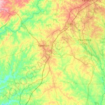
Name: Coweta County topographic map, elevation, terrain.

Location: Coweta County, Georgia, United States (33.19104 -85.01541 33.51176 -84.49704)

Average elevation: 258 m

Minimum elevation: 195 m

Maximum elevation: 377 m

Other topographic maps

Click on a map to view its topography, its elevation and its terrain.

Roswell

United States > Georgia > Fulton County

Average elevation: 316 m

Cumming

United States > Georgia > Forsyth County

Average elevation: 365 m

Marietta

United States > Georgia > Cobb County

Average elevation: 323 m

Fulton County

United States > Georgia

Average elevation: 289 m

Henry County

United States > Georgia

Average elevation: 238 m

Box Springs

United States > Georgia > Talbot County

Average elevation: 124 m

Morganton

United States > Georgia > Fannin County

Average elevation: 538 m

Atlanta

United States > Georgia > Fulton County

Atlanta (/ætˈlæntə/ at-LAN-tə) is the capital and most populous city of the U.S. state of Georgia. It is the seat of Fulton County, the most populous county in Georgia, although a portion of the city extends into neighboring DeKalb county. With a population of 498,715 living within the city limits, it is…

Average elevation: 284 m

Richland

United States > Georgia > Stewart County

Average elevation: 162 m

Leslie

United States > Georgia > Sumter County

Average elevation: 102 m

Mountain Park

United States > Georgia > Gwinnett County

Average elevation: 292 m

Jasper

United States > Georgia > Pickens County

Jasper was founded in 1853 as seat of the newly formed Pickens County. It was incorporated in 1857 as a town and in 1957 as a city. The community is named for William Jasper, a hero of the American Revolutionary War. Jasper is situated at an elevation of 1,463 feet (446 m).

Average elevation: 408 m

Saint Simons

United States > Georgia > Glynn County

Average elevation: 2 m

Lake Joy

United States > Georgia > Houston County

Average elevation: 105 m

Bartow County

United States > Georgia

Average elevation: 262 m

Frontier Trail

United States > Georgia > Hall County

Average elevation: 318 m

Lake Lure Dam

United States > Georgia > Bacon County > Alma

Average elevation: 59 m

Brook Run Park

United States > Georgia > DeKalb County > Dunwoody

Average elevation: 305 m

Mableton

United States > Georgia > Cobb County

Average elevation: 298 m

Villanow

United States > Georgia > Walker County

Average elevation: 282 m

Flowery Branch

United States > Georgia > Hall County

Average elevation: 343 m

Albany

United States > Georgia > Dougherty County

Average elevation: 65 m

Blackshear

United States > Georgia > Pierce County

Average elevation: 38 m

Shadowlawn

United States > Georgia > Camden County > St. Marys

Average elevation: 3 m

Mountville

United States > Georgia > Troup County

Average elevation: 264 m

Westwood

United States > Georgia > Dougherty County > Albany

Average elevation: 68 m

Ash

United States > Georgia > Paulding County

Average elevation: 319 m

Ellenton

United States > Georgia > Colquitt County

Average elevation: 77 m

Dougherty County

United States > Georgia

Average elevation: 69 m

Kingston

United States > Georgia > Bartow County

Average elevation: 223 m

Marble Hill

United States > Georgia > Pickens County

Average elevation: 404 m

Byron

United States > Georgia > Peach County

Average elevation: 141 m

Manor

United States > Georgia > Ware County

Average elevation: 47 m

Weaver Lake

United States > Georgia > Rockdale County > Conyers

Average elevation: 235 m

Univeter

United States > Georgia > Cherokee County > Canton

Average elevation: 328 m

Gordon County

United States > Georgia

Average elevation: 244 m

Sunnydale Acres

United States > Georgia > Bibb County > Macon

Average elevation: 113 m

Buford

United States > Georgia > Gwinnett County

Buford is located in both northern Gwinnett County in northern Georgia, with a small portion extending north into Hall County. The city is a suburb within the Atlanta metropolitan area. According to the United States Census Bureau, as of 2010 the city has a total land area of 17.09 square miles (44.26 km2), of…

Average elevation: 340 m

Early County

United States > Georgia

Average elevation: 64 m

Matt

United States > Georgia > Forsyth County

Average elevation: 353 m

Lumpkin County

United States > Georgia

Average elevation: 554 m

Lake Ranch

United States > Georgia > Hall County

Average elevation: 352 m

Dougherty Lake Dam

United States > Georgia > Bibb County > Macon

Average elevation: 142 m