
Adisham topographic map
Click on the map to display elevation.
About this map
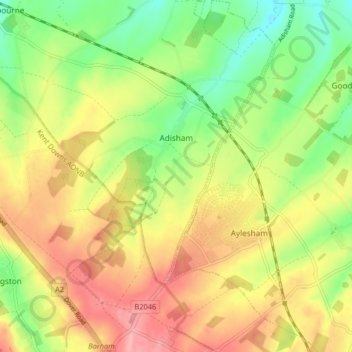
Name: Adisham topographic map, elevation, terrain.
Location: Adisham, Canterbury, Kent, England, United Kingdom (51.20807 1.15391 51.25907 1.21152)
Average elevation: 63 m
Minimum elevation: 11 m
Maximum elevation: 115 m
Kent trails, hiking, mountain biking, running and outdoor activities
Other topographic maps
Click on a map to view its topography, its elevation and its terrain.
Shalmsford Street
United Kingdom > England > Kent > Canterbury > Shalmsford Street
Average elevation: 54 m
Reculver Country Park
United Kingdom > England > Kent > Canterbury > Hillborough
Average elevation: 10 m