
Galicia topographic map
Interactive map
Click on the map to display elevation.
About this map
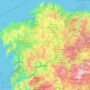
Name: Galicia topographic map, elevation, terrain.
Location: Galicia, Spain (41.80736 -9.30154 43.79042 -6.73395)
Average elevation: 456 m
Minimum elevation: -2 m
Maximum elevation: 2,088 m
The interior of Galicia is characterized by a hilly landscape; mountain ranges rise to 2,000 m (6,600 ft) in the east and south. The coastal areas are mostly an alternate series of rias and beaches. The climate of Galicia is usually temperate and rainy, with markedly drier summers; it is usually classified as Oceanic. Its topographic and climatic conditions have made animal husbandry and farming the primary source of Galicia's wealth for most of its history, allowing for a relatively high density of population. Except shipbuilding and food processing, Galicia was based on a farming and fishing economy until after the mid-20th century, when it began to industrialize. In 2018, the nominal gross domestic product was €62.900 billion, with a nominal GDP per capita of €23,300. Galicia is characterised, unlike other Spanish regions, by the absence of a metropolis dominating the territory. Indeed, the urban network is made up of 7 main cities (the four provincial capitals A Coruña, Pontevedra, Ourense and Lugo, the political capital Santiago de Compostela and the industrial cities Vigo and Ferrol and other small towns. The population is largely concentrated in two main areas: from Ferrol to A Coruña on the northern coast, and in the Rías Baixas region in the southwest, including the cities of Vigo, Pontevedra, and the interior city of Santiago de Compostela. There are smaller populations around the interior cities of Lugo and Ourense. The political capital is Santiago de Compostela, in the province of A Coruña. Vigo, in the province of Pontevedra, is the largest municipality in Galicia and also the most populated city. Two languages are official and widely used today in Galicia: the native Galician, a Romance language closely related to Portuguese with which it shares the Galician-Portuguese medieval literature; and Spanish, usually called Castilian. While most Galicians are bilingual, a 2013 survey reported that 51% of the Galician population spoke Galician most often on a day-to-day basis, while 48% most often used Spanish.
Other topographic maps
Click on a map to view its topography, its elevation and its terrain.
Bianditz
Spain > Navarre > Baztan-Bidasoa > Lesaka
Bianditz, Lesaka, Baztan-Bidasoa, Navarre, Spain
Average elevation: 632 m
Barcelona
Spain > Catalonia > Barcelonès
Barcelona, Barcelonès, Barcelona, Catalonia, 08001, Spain
Average elevation: 65 m
Granada
Spain > Andalusia > Comarca de la Vega de Granada
Granada, Comarca de la Vega de Granada, Granada, Andalusia, Spain
Average elevation: 829 m
Planes
Planes, el Comtat, Alacant / Alicante, Valencian Community, Spain
Average elevation: 523 m
Truchas / Trueitas
Spain > Castile and León > Truchas
Truchas / Trueitas, Truchas, León, Castile and León, 24740, Spain
Average elevation: 1,210 m
Málaga
Spain > Andalusia > Málaga-Costa del Sol
Málaga, Málaga-Costa del Sol, Malaga, Andalusia, Spain
Average elevation: 276 m
As Brañas
Spain > Galicia > Betanzos > O Pazo de Irixoa
As Brañas, Mántaras, O Pazo de Irixoa, Irixoa, Betanzos, A Coruña, Galicia, 15313, Spain
Average elevation: 379 m
Alicante
Alicante, l'Alacantí, Alacant / Alicante, Valencian Community, Spain
Average elevation: 143 m
As Brañas
Spain > Galicia > Bergantiños > A Laracha
As Brañas, Torás, A Laracha, Bergantiños, A Coruña, Galicia, 15145, Spain
Average elevation: 176 m
As Brañas
Spain > Galicia > A Mariña Oriental
As Brañas, San Pedro de Benquerencia, Barreiros, A Mariña Oriental, Lugo, Galicia, 27793, Spain
Average elevation: 20 m
Casas del Lomo
Casas del Lomo, Tejeda, Las Palmas, Canary Islands, 35360, Spain
Average elevation: 1,226 m
Iznate
Spain > Andalusia > La Axarquía
Iznate, La Axarquía, Malaga, Andalusia, 29792, Spain
Average elevation: 251 m
Cornudella de Montsant
Cornudella de Montsant, Priorat, Tarragona, Catalonia, 43360, Spain
Average elevation: 700 m
Panticosa
Spain > Aragon > Alto Gállego
Panticosa, Alto Gállego, Huesca, Aragon, Spain
Average elevation: 1,916 m
Veleta
Spain > Castile and León > Valle del Retortillo
Veleta, Valle del Retortillo, Palencia, Castile and León, 34307, Spain
Average elevation: 791 m
Campell
Spain > Valencian Community > Pedreguer
Campell, Pedreguer, la Marina Alta, Alacant / Alicante, Valencian Community, 03750, Spain
Average elevation: 115 m
Ronda
Spain > Andalusia > Serranía de Ronda
Ronda, Serranía de Ronda, Malaga, Andalusia, Spain
Average elevation: 801 m
Trillo
Trillo, Guadalajara, Castile-La Mancha, 19450, Spain
Average elevation: 899 m
Sant Martí
Spain > Catalonia > Barcelonès > Barcelona
Sant Martí, Barcelona, Barcelonès, Barcelona, Catalonia, 08001, Spain
Average elevation: 17 m
Hospital
Spain > Galicia > Os Ancares > Pedrafita do Cebreiro
Hospital, Pedrafita do Cebreiro, Os Ancares, Lugo, Galicia, Spain
Average elevation: 1,184 m
Aldeatejada
Aldeatejada, Salamanca, Castile and León, Spain
Average elevation: 838 m
Vinaròs
Vinaròs, el Baix Maestrat, Castelló / Castellón, Valencian Community, 12500, Spain
Average elevation: 54 m