
Make a donation
Gear up for your next adventure:
As an Amazon Associate, this site earns from qualifying purchases at no extra cost to you.
La Palma topographic map
Click on the map to display elevation.
Make a donation
Gear up for your next adventure:
As an Amazon Associate, this site earns from qualifying purchases at no extra cost to you.
La Palma
In a programme transmitted by the British Broadcasting Corporation BBC Horizon broadcast on 12 October 2000, two geologists (Day and McGuire) cited La Grieta as proof that half of the Cumbre Vieja had moved towards the Atlantic Ocean (Day et al. 1999, and Ward and Day, 2001). They postulate that this process was driven by the pressure caused by the rising magma heating water trapped within the structure of the island. They hypothesised that during a future eruption, the western flank of the Cumbre Vieja, with a mass of approximately 1.5 x10¹⁵ kg, could slide into the ocean. This could then potentially generate a giant wave, known as a "megatsunami" around 650–900 m (2,130–2,950 ft) high in the region of the islands. The wave would radiate out across the Atlantic and inundate much of the eastern seaboard of North America about 7 hours later, many of the islands in the Caribbean and northern coasts of South America between six and eight hours later. They estimate that the tsunami will have waves possibly 50 m (164 ft) or higher causing massive devastation along the coastlines. Modelling suggests that the tsunami could inundate up to 25 km (16 mi) inland – depending upon topography. The basis for Ward and Day (2001) modelling the collapse of a much larger portion of the western flank than what the currently visible surface crack indicates as being potentially unstable, was based on geological mapping by Day et al. (1999). In this paper they argue that a large part of the western flank has been constructed in the scar of a previous collapse and therefore sits upon unstable debris.
Make a donation
Gear up for your next adventure:
As an Amazon Associate, this site earns from qualifying purchases at no extra cost to you.
About this map
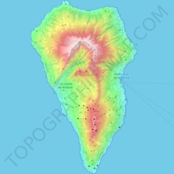
Name: La Palma topographic map, elevation, terrain.
Location: La Palma, Santa Cruz de Tenerife, Canary Islands, Spain (28.45271 -18.00725 28.85754 -17.72422)
Average elevation: 296 m
Minimum elevation: 0 m
Maximum elevation: 2,410 m
Make a donation
Gear up for your next adventure:
As an Amazon Associate, this site earns from qualifying purchases at no extra cost to you.
Other topographic maps
Click on a map to view its topography, its elevation and its terrain.
Make a donation
Gear up for your next adventure:
As an Amazon Associate, this site earns from qualifying purchases at no extra cost to you.
Make a donation
Gear up for your next adventure:
As an Amazon Associate, this site earns from qualifying purchases at no extra cost to you.
Make a donation
Gear up for your next adventure:
As an Amazon Associate, this site earns from qualifying purchases at no extra cost to you.
Corró d'Amunt
Spain > Catalonia > Vallès Oriental > les Franqueses del Vallès
Average elevation: 287 m
Make a donation
Gear up for your next adventure:
As an Amazon Associate, this site earns from qualifying purchases at no extra cost to you.
Alhambra
Spain > Andalusia > Partido Judicial de Granada > Granada
During the reign of the Nasrid Dynasty, the Alhambra was transformed into a palatine city, complete with an irrigation system composed of aqueducts and water channels that provided water for the complex and for other nearby countryside palaces such as the Generalife. Previously, the old fortresses on the hill…
Average elevation: 759 m
Make a donation
Gear up for your next adventure:
As an Amazon Associate, this site earns from qualifying purchases at no extra cost to you.
Make a donation
Gear up for your next adventure:
As an Amazon Associate, this site earns from qualifying purchases at no extra cost to you.
Make a donation
Gear up for your next adventure:
As an Amazon Associate, this site earns from qualifying purchases at no extra cost to you.
Make a donation
Gear up for your next adventure:
As an Amazon Associate, this site earns from qualifying purchases at no extra cost to you.
Make a donation
Gear up for your next adventure:
As an Amazon Associate, this site earns from qualifying purchases at no extra cost to you.
"El Cerro la Silla" (Cima oeste)
Spain > Aragon > Campo de Cariñena > Cosuenda
Average elevation: 954 m
Make a donation
Gear up for your next adventure:
As an Amazon Associate, this site earns from qualifying purchases at no extra cost to you.
Make a donation
Gear up for your next adventure:
As an Amazon Associate, this site earns from qualifying purchases at no extra cost to you.
Make a donation
Gear up for your next adventure:
As an Amazon Associate, this site earns from qualifying purchases at no extra cost to you.
Make a donation
Gear up for your next adventure:
As an Amazon Associate, this site earns from qualifying purchases at no extra cost to you.
Make a donation
Gear up for your next adventure:
As an Amazon Associate, this site earns from qualifying purchases at no extra cost to you.
Peñon de Bodíjar
Spain > Andalusia > Comarca de la Costa Granadina > Los Guájares
Average elevation: 870 m
Make a donation
Gear up for your next adventure:
As an Amazon Associate, this site earns from qualifying purchases at no extra cost to you.
Make a donation
Gear up for your next adventure:
As an Amazon Associate, this site earns from qualifying purchases at no extra cost to you.
Make a donation
Gear up for your next adventure:
As an Amazon Associate, this site earns from qualifying purchases at no extra cost to you.
Cortijo ruinas
Spain > Andalusia > Comarca de la Alpujarra Granadina > Capileira
Average elevation: 2,246 m
Make a donation
Gear up for your next adventure:
As an Amazon Associate, this site earns from qualifying purchases at no extra cost to you.
Poblado de Doña Blanca
Spain > Andalusia > Bay of Cádiz > El Puerto de Santa María
Average elevation: 13 m
Make a donation
Gear up for your next adventure:
As an Amazon Associate, this site earns from qualifying purchases at no extra cost to you.
Parque de la Puerta de Tierra
Spain > Canary Islands > San Juan del Reparo (La Culata) > San Pedro de Daute
Average elevation: 182 m
Make a donation
Gear up for your next adventure:
As an Amazon Associate, this site earns from qualifying purchases at no extra cost to you.
Marabi
Spain > Autonomous Community of the Basque Country > Amorebieta-Etxano
Average elevation: 161 m
Make a donation
Gear up for your next adventure:
As an Amazon Associate, this site earns from qualifying purchases at no extra cost to you.
La Mata
Spain > Valencian Community > el Baix Segura / La Vega Baja > Torrevieja
Average elevation: 5 m
Make a donation
Gear up for your next adventure:
As an Amazon Associate, this site earns from qualifying purchases at no extra cost to you.
Make a donation
Gear up for your next adventure:
As an Amazon Associate, this site earns from qualifying purchases at no extra cost to you.
Make a donation
Gear up for your next adventure:
As an Amazon Associate, this site earns from qualifying purchases at no extra cost to you.
Make a donation
Gear up for your next adventure:
As an Amazon Associate, this site earns from qualifying purchases at no extra cost to you.