Čadca topographic map
Click on the map to display elevation.
Čadca
The municipality lies at an altitude of 506 metres (1,660 ft) and covers an area of 56.76 km2 (21.92 sq mi) (2025).
About this map
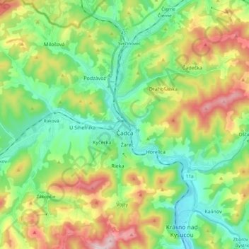
Name: Čadca topographic map, elevation, terrain.
Location: Čadca, District of Čadca, Region of Žilina, Slovakia (49.38073 18.71301 49.50161 18.88334)
Average elevation: 560 m
Minimum elevation: 379 m
Maximum elevation: 909 m
Other topographic maps
Click on a map to view its topography, its elevation and its terrain.
Bratislava
Slovakia > Region of Bratislava > District of Bratislava I > Old Town
The Carpathian mountain range begins in city territory with the Little Carpathians (Malé Karpaty). The Záhorie and Danubian lowlands stretch into Bratislava. The city's lowest point is at the Danube's surface at 126 metres (413 ft) above mean sea level, and the highest point is Devínska Kobyla at 514 metres…
Average elevation: 175 m




Trnava
The municipality lies at an altitude of 144 metres (472 ft) and covers an area of 71.53 km2 (27.62 sq mi) (2025). It is located in the Danubian Lowland on the Trnávka river, around 45 kilometres (28 mi) north-east of Bratislava, 50 kilometres (31 mi) west of Nitra and around 70 kilometres (43 mi) from the…
Average elevation: 151 m

Vodná nádrž Veľká Domaša
Slovakia > Region of Prešov > District of Vranov nad Topľou > Nová Kelča
Domaša is spread over the area of the districts of Vranov nad Topľou and Stropkov at the average altitude of 156 m (512 ft). With an agreeable climate and an average temperature of 23 °C (73 °F) it guarantees pleasant swimming in clean water from June to mid-September.
Average elevation: 268 m
Gerlachovský štít
Slovakia > Region of Prešov > District of Poprad
Gerlachovský štít (Slovak pronunciation, translated into English as Gerlachov Peak, German: Gerlsdorfer Spitze, Hungarian: Gerlachfalvi-csúcs), informally referred to as Gerlach, is the highest peak in the High Tatras, in Slovakia, and in the Carpathian Mountains. Its elevation is usually listed at 2654.4…
Average elevation: 2,103 m
Rysy
It is possible to reach the peak from the Slovak side, starting at Štrbské pleso and passing Chata pod Rysmi, a mountain chalet at an altitude of 2,250 m (7,380 ft). Between November 1 and June 15, the trail and chalet on the Slovak side are closed.
Average elevation: 2,005 m

Tomášovo
Slovakia > Region of Banská Bystrica > District of Rimavská Sobota > Hnúšťa > Polom
Average elevation: 649 m

Kriváň
Slovakia > Region of Prešov > District of Poprad > Vysoké Tatry
The relative elevations of the two mountains were determined by the English natural historian Robert Townson, who ascended both peaks in August 1793 and also made an early recorded comment on Kriváň's aesthetic appeal.
Average elevation: 1,913 m

Castle
Slovakia > Region of Nitra > District of Zlaté Moravce > Vieska nad Žitavou
Average elevation: 187 m
Veľká Javorina
Slovakia > Region of Trenčín > District of Nové Mesto nad Váhom
The massif of Velká Javořina is located in the southwest part of the White Carpathians and is built of flysch rocks with significant thickness, in which layers of sandstone (dating from the Upper Cretaceous to the Lower Paleocene) and fine-grained marine sediments (shales and marls) rhythmically repeat. The…
Average elevation: 774 m
Havran
Slovakia > Region of Prešov > District of Poprad > Tatranská Javorina
Average elevation: 1,624 m
Volovec / Wołowiec
Slovakia > Region of Žilina > District of Liptovský Mikuláš
There are two marked hiking trails which lead to the summit of Volovec, red and blue. A third, green one, connects with the blue one at the saddle beneath the mountain. All routes pose no technical difficulty and when taking into account the relatively large distance and altitude difference involved, the…
Average elevation: 1,678 m
Ochodnica
Slovakia > Region of Žilina > District of Kysucké Nové Mesto > Ochodnica > Ochodnica
Average elevation: 502 m
Danube
Slovakia > Region of Bratislava > District of Senec > Bratislava > Čunovo
Average elevation: 125 m
Chopok
Slovakia > Region of Banská Bystrica > District of Brezno > Horná Lehota
Average elevation: 1,642 m
Kráľova hoľa
Slovakia > Region of Banská Bystrica > District of Brezno
Kráľova hoľa (Slovak pronunciation: [ˈkraːʎɔʋa ˈɦɔʎa]; German: Königsberg; Hungarian: Király-hegy, literally "King's Mountain") is the highest mountain (1,946 m) of the eastern part of the Low Tatras in central Slovakia. Four rivers rise at its foot: Čierny Váh, Hnilec, Hornád, and Hron. The…
Average elevation: 1,653 m
Poprad
Slovakia > Region of Prešov > District of Poprad > Poprad > Poprad
International Poprad–Tatry Airport from 1938, is an airport with the highest elevations in Central Europe. It also offers scheduled flights to London.
Average elevation: 699 m
Kriváň
Slovakia > Region of Prešov > District of Poprad
The relative elevations of the two mountains were determined by the English natural historian Robert Townson, who ascended both peaks in August 1793 and also made an early recorded comment on Kriváň's aesthetic appeal.
Average elevation: 1,913 m

Nad lomom
Slovakia > Region of Prešov > District of Prešov > Drienovská Nová Ves
Average elevation: 294 m
Tatralandia
Slovakia > Region of Žilina > District of Liptovský Mikuláš > Liptovský Mikuláš
Average elevation: 590 m

Ďumbier
Slovakia > Region of Žilina > District of Liptovský Mikuláš > Liptovský Ján
Average elevation: 1,669 m

Mišúty
Slovakia > Region of Banská Bystrica > District of Banská Bystrica > Donovaly
Average elevation: 1,041 m
Rysy
Slovakia > Region of Prešov > District of Poprad
It is possible to reach the peak from the Slovak side, starting at Štrbské pleso and passing Chata pod Rysmi, a mountain chalet at an altitude of 2,250 m (7,380 ft). Between November 1 and June 15, the trail and chalet on the Slovak side are closed.
Average elevation: 2,005 m
Chopok
Slovakia > Region of Banská Bystrica > District of Brezno > Horná Lehota
Average elevation: 1,642 m
Veľkobielske jazero "Šutrovka"
Slovakia > Region of Bratislava > District of Senec > Veľký Biel
Average elevation: 127 m
Košické Hámre
Slovakia > Region of Košice > District of Košice - okolie > Košická Belá
Average elevation: 443 m
Chopok
Slovakia > Region of Banská Bystrica > District of Brezno > Horná Lehota
Average elevation: 1,642 m

Pod Holým vrchom
Slovakia > Region of Trnava > District of Piešťany > Dolný Lopašov
Average elevation: 256 m
Medený vodopád
Slovakia > Region of Prešov > District of Poprad > Vysoké Tatry
Average elevation: 2,004 m
Michalovce
Slovakia > Region of Košice > District of Michalovce > Michalovce > Michalovce
Average elevation: 113 m
Nižnoslanská Baňa
Slovakia > Region of Košice > District of Rožňava > Nižná Slaná
Average elevation: 503 m
Devín Castle
Slovakia > Region of Bratislava > Bratislava > District of Bratislava IV > Devín
The cliff (elevation 212 meters) is an ideal place for a fort due to its position at the confluence of the Danube and Morava rivers. The fort watches over an important trade route along the Danube as well as one branch of the Amber Road.
Average elevation: 175 m
Rudno
Slovakia > Region of Žilina > District of Turčianske Teplice > Rudno > Rudno
Average elevation: 525 m
Druhý Mních / Zadni Mnich
Slovakia > Region of Prešov > District of Poprad > Vysoké Tatry
Average elevation: 1,921 m