

Trnava topographic map
Click on the map to display elevation.
Trnava
The municipality lies at an altitude of 144 metres (472 ft) and covers an area of 71.53 km2 (27.62 sq mi) (2025). It is located in the Danubian Lowland on the Trnávka river, around 45 kilometres (28 mi) north-east of Bratislava, 50 kilometres (31 mi) west of Nitra and around 70 kilometres (43 mi) from the Czech border. The closest mountain ranges are the Little Carpathians to the west and the Považský Inovec to the north-east of the city.
About this map
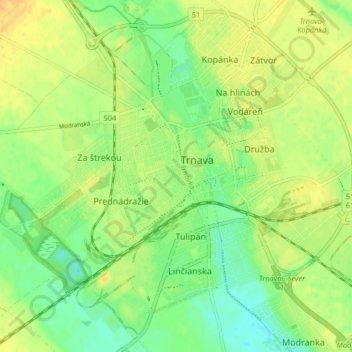
Name: Trnava topographic map, elevation, terrain.
Location: Trnava, District of Trnava, Region of Trnava, Slovakia (48.34915 17.54039 48.39942 17.62150)
Average elevation: 151 m
Minimum elevation: 136 m
Maximum elevation: 165 m
Other topographic maps
Click on a map to view its topography, its elevation and its terrain.
Tatra Mountains
The Tatras lie in the temperate zone of Central Europe. They are an important barrier to the movements of air masses. Their mountainous topography causes one of the most diverse climates in that region.
Average elevation: 1,001 m
Bratislava
Slovakia > Region of Bratislava > District of Bratislava I > Old Town
The Carpathian mountain range begins in city territory with the Little Carpathians (Malé Karpaty). The Záhorie and Danubian lowlands stretch into Bratislava. The city's lowest point is at the Danube's surface at 126 metres (413 ft) above mean sea level, and the highest point is Devínska Kobyla at 514 metres…
Average elevation: 175 m

Tureň
Slovakia > Region of Bratislava > District of Senec
The municipality lies at an altitude of 126 metres (413 ft) and covers an area of 5.30 km2 (2.05 sq mi) (2025).
Average elevation: 126 m

Humenné
Slovakia > Region of Prešov > District of Humenné
The municipality lies at an altitude of 155 metres (509 ft) and covers an area of 32.26 km2 (12.46 sq mi) (2025).
Average elevation: 208 m

Selce
Slovakia > Region of Banská Bystrica
The municipality lies at an altitude of 424 metres (1,391 ft) and covers an area of 19.99 km2 (7.72 sq mi) (2025).
Average elevation: 587 m


Licince
Slovakia > Region of Banská Bystrica
The municipality lies at an altitude of 210 metres (690 ft) and covers an area of 18.27 km2 (7.05 sq mi) (2025).
Average elevation: 261 m

Štvrtok na Ostrove
Slovakia > Region of Trnava > District of Dunajská Streda
The village is in the Danubian Lowland and is in the western part of Žitný ostrov (Csallóköz). The municipality lies at an altitude of 128 metres (420 ft) and covers an area of 13.06 km2 (5.04 sq mi) (2025).
Average elevation: 126 m

Zádiel
Slovakia > Region of Košice > Košice-okolie District
The municipality lies at an altitude of 246 metres (807 ft) and covers an area of 3.51 km2 (1.36 sq mi) (2025).
Average elevation: 359 m

Banka
The municipality lies at an altitude of 177 metres (581 ft) and covers an area of 8.58 km2 (3.31 sq mi) (2025).
Average elevation: 220 m

Olováry
Slovakia > Region of Banská Bystrica > District of Veľký Krtíš
The municipality lies at an altitude of 190 metres (620 ft) and covers an area of 18.61 km2 (7.19 sq mi) (2025).
Average elevation: 211 m

Brezov
Slovakia > Region of Prešov > District of Bardejov
The municipality lies at an altitude of 190 metres (620 ft) and covers an area of 6.89 km2 (2.66 sq mi) (2025).
Average elevation: 238 m
Banská Štiavnica
Slovakia > Region of Banská Bystrica > District of Banská Štiavnica
Average elevation: 622 m


Šandal
The municipality lies at an altitude of 252 metres (827 ft) and covers an area of 10.88 km2 (4.20 sq mi) (2025).
Average elevation: 283 m
Telgárt
Slovakia > Region of Banská Bystrica
The municipality lies at an altitude of 886 metres (2,907 ft) and covers an area of 56.00 km2 (21.62 sq mi) (2025). The Hron river rises in the cadastral area of the village, under the Kráľova hoľa mountain.
Average elevation: 1,091 m
Štrba
The municipality lies at an altitude of 1,020 metres (3,350 ft) and covers an area of 42.96 km2 (16.59 sq mi) (2025). Its detached borough of Tatranská Štrba hosts the Štrba railway station, the valley terminus of the Štrbské Pleso–Štrba rack railway, and a stop on one of Slovakia's major railways. The…
Average elevation: 1,134 m
Žilina
The municipality lies at an altitude of 378 metres (1,240 ft) and covers an area of 80.02 km2 (30.90 sq mi) (2025). It is located in the Upper Váh region (Slovak: Horné Považie) at the confluence of three rivers: Váh, flowing from the east into the south-west, Kysuca, flowing from the north and Rajčanka…
Average elevation: 424 m

Oľšinkov
Slovakia > Region of Prešov > District of Medzilaborce
The municipality lies at an altitude of 443 metres (1,453 ft) and covers an area of 7.65 km2 (2.95 sq mi) (2025).
Average elevation: 543 m
Bratislava
The Carpathian mountain range begins in city territory with the Little Carpathians (Malé Karpaty). The Záhorie and Danubian lowlands stretch into Bratislava. The city's lowest point is at the Danube's surface at 126 metres (413 ft) above mean sea level, and the highest point is Devínska Kobyla at 514 metres…
Average elevation: 172 m
Banská Bystrica
Banská Bystrica lies at an altitude of 368 metres (1,207 ft) above sea level and covers an area of 103.36 square kilometres (39.9 sq mi). It is about halfway between Slovakia's two largest cities, 208 kilometres (129 mi) north-east from Slovakia's capital Bratislava and 217 kilometres (135 mi) west of…
Average elevation: 583 m

Tatra Mountains
The Tatras lie in the temperate zone of Central Europe. They are an important barrier to the movements of air masses. Their mountainous topography causes one of the most diverse climates in that region.
Average elevation: 1,001 m


Bratislava
Slovakia > Region of Bratislava
The Carpathian mountain range begins in city territory with the Little Carpathians (Malé Karpaty). The Záhorie and Danubian lowlands stretch into Bratislava. The city's lowest point is at the Danube's surface at 126 metres (413 ft) above mean sea level, and the highest point is Devínska Kobyla at 514 metres…
Average elevation: 172 m


Sady nad Torysou
The municipality lies at an altitude of 204 metres (669 ft) and covers an area of 8.44 km2 (3.26 sq mi) (2025).
Average elevation: 240 m


Košice
Košice lies at an altitude of 206 metres (676 ft) above sea level and covers an area of 242.77 square kilometres (93.7 sq mi). It is located in eastern Slovakia, about 20 kilometres (12 mi) from the Hungarian, 80 kilometres (50 mi) from the Ukrainian, and 90 kilometres (56 mi) from the Polish borders. It is…
Average elevation: 314 m

Bánovce nad Bebravou
The municipality lies at an altitude of 209 metres (686 ft) and covers an area of 26.45 km2 (10.21 sq mi) (2025).
Average elevation: 235 m
Prievidza
The municipality lies at an altitude of 309 metres (1,014 ft) and covers an area of 43.06 km2 (16.63 sq mi) (2025). The city is near the smaller town of Bojnice, sharing a public transport system. The valley of the Nitra River, in which the city lies, is surrounded by mountain ranges on all sides, in the west…
Average elevation: 346 m

Hamuliakovo
The municipality lies at an altitude of 128 metres (420 ft) and covers an area of 10.94 km2 (4.22 sq mi) (2025).
Average elevation: 126 m
Nové Mesto nad Váhom
The municipality lies at an altitude of 189 metres (620 ft) and covers an area of 32.58 km2 (12.58 sq mi) (2025).
Average elevation: 229 m



Želiezovce
The municipality lies at an altitude of 139 metres (456 ft) and covers an area of 56.52 km2 (21.82 sq mi) (2025).
Average elevation: 149 m


Partizánske
The municipality lies at an altitude of 190 metres (620 ft) and covers an area of 22.37 km2 (8.64 sq mi) (2025).
Average elevation: 238 m


Dolný Badín
The municipality lies at an altitude of 305 metres (1,001 ft) and covers an area of 6.24 km2 (2.41 sq mi) (2025).
Average elevation: 322 m



Vysoká pri Morave
The municipality lies at an altitude of 144 metres (472 ft) and covers an area of 33.57 km2 (12.96 sq mi) (2025).
Average elevation: 144 m

Žilina
Žilina lies at an altitude of 342 metres (1,122 ft) above sea level and covers an area of 80.03 square kilometres (30.9 sq mi). It is located in the Upper Váh region (Slovak: Horné Považie) at the confluence of three rivers: Váh, flowing from the east into the south-west, Kysuca, flowing from the north…
Average elevation: 424 m
Prešov
The municipality lies at an altitude of 296 metres (971 ft) and covers an area of 71.09 km2 (27.45 sq mi) (2025). It is located in north-eastern Slovakia, at the northern reaches of the Košice Basin, at the confluence of the Torysa river with its tributary Sekčov. Mountain ranges nearby include Slanské…
Average elevation: 323 m
Vysoké Tatry
The town of Vysoké Tatry is special in many aspects. It is not a true town, but a conglomerate of separate and different settlements (originally separate villages), whose only common feature is that they are the main tourist resorts in the Slovak High Tatras, while being connected through a common railway…
Average elevation: 1,027 m
Nitra
Nitra lies at an altitude of 190 metres (623 ft) above sea level and covers an area of 100.48 square kilometres (38.8 sq mi). It is located in the Nitra River valley in the Danubian Lowland, where the bigger part of the city is located. A smaller part is located at the southernmost reaches of the Tribeč…
Average elevation: 197 m


Bratislava
Slovakia > Region of Bratislava
The Carpathian mountain range begins in city territory with the Little Carpathians (Malé Karpaty). The Záhorie and Danubian lowlands stretch into Bratislava. The city's lowest point is at the Danube's surface at 126 metres (413 ft) above mean sea level, and the highest point is Devínska Kobyla at 514 metres…
Average elevation: 168 m

Tatra Mountains
The Tatras lie in the temperate zone of Central Europe. They are an important barrier to the movements of air masses. Their mountainous topography causes one of the most diverse climates in that region.
Average elevation: 1,001 m
Bratislava
Slovakia > Region of Bratislava
The Carpathian mountain range begins in city territory with the Little Carpathians (Malé Karpaty). The Záhorie and Danubian lowlands stretch into Bratislava. The city's lowest point is at the Danube's surface at 126 metres (413 ft) above mean sea level, and the highest point is Devínska Kobyla at 514 metres…
Average elevation: 168 m
Tatra Mountains
The Tatras lie in the temperate zone of Central Europe. They are an important barrier to the movements of air masses. Their mountainous topography causes one of the most diverse climates in that region.
Average elevation: 1,001 m


Trenčín
Trenčín lies at an altitude of 262 metres (860 ft) above sea level and covers an area of 82 square kilometres (31.7 sq mi). It lies in the Trenčín Basin of north-western Slovakia, which is surrounded by the Strážov Mountains, Považský Inovec and White Carpathians, with the last mentioned being a…
Average elevation: 307 m
Banská Bystrica
Slovakia > Region of Banská Bystrica > District of Banská Bystrica
Banská Bystrica lies at an altitude of 362 metres (1,188 ft) above sea level and covers an area of 103.37 square kilometres (39.9 sq mi). It is about halfway between Slovakia's two largest cities, 208 kilometres (129 mi) north-east from Slovakia's capital Bratislava and 217 kilometres (135 mi) west of…
Average elevation: 564 m
Martin
Slovakia > Region of Žilina > District of Martin
Martin lies at an altitude of 395 metres (1,296 ft) above sea level and covers an area of 67.74 square kilometres (26.2 sq mi). It is located in northern Slovakia, in the Turiec Basin, just south of the confluence of the Turiec river with Váh. Mountain ranges in the proximity of the city are Malá Fatra…
Average elevation: 484 m

Banská Bystrica
Slovakia > Region of Banská Bystrica > District of Banská Bystrica
Banská Bystrica lies at an altitude of 368 metres (1,207 ft) above sea level and covers an area of 103.36 square kilometres (39.9 sq mi). It is about halfway between Slovakia's two largest cities, 208 kilometres (129 mi) north-east from Slovakia's capital Bratislava and 217 kilometres (135 mi) west of…
Average elevation: 434 m
Mníšek nad Popradom
The municipality lies at an altitude of 439 metres (1,440 ft) and covers an area of 17.93 km2 (6.92 sq mi) (2025). The village lies near the Poprad river and is directly at the border with Poland, with a 24-hour border crossing.
Average elevation: 584 m
Sereď
The municipality lies at an altitude of 128 metres (420 ft) and covers an area of 30.72 km2 (11.86 sq mi) (2025). It is located in the Danubian Lowland on the Váh river, around 20 kilometres (12 mi) south-east of Trnava, 33 kilometres (21 mi) west of Nitra and around 55 kilometres (34 mi) east from…
Average elevation: 132 m
Gerlachovský štít
Slovakia > Region of Prešov > District of Poprad
Gerlachovský štít (Slovak pronunciation, translated into English as Gerlachov Peak, German: Gerlsdorfer Spitze, Hungarian: Gerlachfalvi-csúcs), informally referred to as Gerlach, is the highest peak in the High Tatras, in Slovakia, and in the Carpathian Mountains. Its elevation is usually listed at 2654.4…
Average elevation: 2,103 m

Rysy
It is possible to reach the peak from the Slovak side, starting at Štrbské pleso and passing Chata pod Rysmi, a mountain chalet at an altitude of 2,250 m (7,380 ft). Between November 1 and June 15, the trail and chalet on the Slovak side are closed.
Average elevation: 2,005 m
Košice
Košice lies at an altitude of 206 metres (676 ft) above sea level and covers an area of 242.77 square kilometres (93.7 sq mi). It is located in eastern Slovakia, about 20 kilometres (12 mi) from the Hungarian, 80 kilometres (50 mi) from the Ukrainian, and 90 kilometres (56 mi) from the Polish borders. It is…
Average elevation: 314 m
Komárno
Slovakia > Region of Nitra > District of Komárno
The municipality lies at an altitude of 109 metres (358 ft) and covers an area of 103.16 km2 (39.83 sq mi) (2024).
Average elevation: 109 m
Low Tatras National Park
Slovakia > Region of Banská Bystrica > District of Brezno
Average elevation: 890 m

Mokrance
Slovakia > Region of Košice > District of Košice - okolie
The municipality lies at an altitude of 200 metres (660 ft) and covers an area of 23.41 km2 (9.04 sq mi) (2025).
Average elevation: 230 m
Poprad
Slovakia > Region of Prešov > District of Poprad
Poprad lies at an altitude of 672 metres (2,205 ft) above sea level and covers an area of 63 square kilometres (24.3 sq mi). It is located in northeastern Slovakia, about 110 kilometres (68 mi) from Košice and 330 kilometres (205 mi) from Bratislava (by road).
Average elevation: 709 m
Štrba - Štrbské pleso
Slovakia > Region of Prešov > District of Poprad > Štrba
Average elevation: 1,597 m
Bratislava
Slovakia > Region of Bratislava
The Carpathian mountain range begins in city territory with the Little Carpathians (Malé Karpaty). The Záhorie and Danubian lowlands stretch into Bratislava. The city's lowest point is at the Danube's surface at 126 metres (413 ft) above mean sea level, and the highest point is Devínska Kobyla at 514 metres…
Average elevation: 172 m
Starý Smokovec
Slovakia > Region of Prešov > District of Poprad > Vysoké Tatry
Average elevation: 1,065 m
Kremnica
Slovakia > Region of Banská Bystrica
Kremnica lies at an altitude of 564 metres (1,850 ft) above sea level and covers an area of 43.136 square kilometres (16.7 sq mi). It is located in the Kremnica Mountains on the brook Kremnický potok, which is a tributary of the Hron River. It is located around 20 kilometres (12 mi) west of Banská Bystrica…
Average elevation: 786 m
Michalovce
Slovakia > Region of Košice > District of Michalovce
The municipality lies at an altitude of 113 metres (371 ft) and covers an area of 52.80 km2 (20.39 sq mi) (2025).
Average elevation: 114 m